A space launch vehicle by any other name…<< page 1: rockets, missiles, and space launch vehicles Full spectrum intelligenceWhen North Korea does attempt its next launch, once again a significant number of intelligence assets from several nations will be watching very closely. These assets will be collecting data across the entire electromagnetic spectrum, including infrared, optical, and radar, as well as attempting to capture signals and telemetry from the booster. Their goal is twofold: to determine if the launch is a threat to the United States or its allies, and collect information on the performance of the booster.
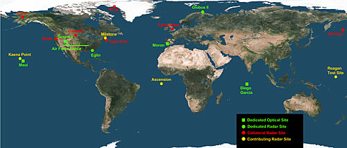
The first indications after launch will probably be from the Defense Support Program (DSP) infrared early warning satellites in geostationary orbit, along with the newly placed Space Based Infrared Satellites (SBIRS) in a highly elliptical orbit. These satellites stare back at the Earth looking for the heat signature from missile and space launchers. During the boost phase, the length and intensity of each rocket stage will be critical to determine what type of missile or space launch vehicle it is. Additionally, the heading the vehicle travels in will be the major piece of data used to determine if it poses a threat. For a space launch, the heading (or azimuth) of the rocket combined with the launch site’s latitude determines the final orbital inclination of the payload. A heading of due East from the launch site (90° azimuth) results in an inclination equal to the launch site latitude. This is also the most efficient way to launch since it takes the most advantage of the Earth’s rotation to provide an added boost to the satellite. It is easy to launch into an inclination higher than a launch site’s latitude by flying on an azimuth other than 90°. For this reason, the Space Shuttle launching out of Kennedy Space Center (latitude 28.5°) can easily reach the International Space Station at 51.6° inclination. It is impossible to launch directly into an inclination lower than the launch site’s latitude without expending a large amount of booster velocity doglegging during the boost phase or fuel in an orbital maneuver. So if the ISS was located at 28.5° it would be difficult to reach it with Progress resupply vehicles from the Baikonour Cosmodrome (47°). This is why launch sites at or near the Equator are highly desirable, as you can launch into any inclination from them and get maximum benefit of the Earth’s rotational speed. For this reason, Sea Launch moves their launch vehicle from its base of operations in Long Beach, California to a position on the Equator in the Pacific. This allows them to launch directly into a zero degree inclination transfer orbit heading due East, a very efficient means of reaching geostationary orbit. Another factor taken into consideration by most states when launching a ballistic missile or space launch vehicle is safety. In order to avoid giving the impression that the booster presents a threat to other nations, almost all states avoid overflying the sovereign territory of other states with the booster. Likewise, many also take care to ensure that the spent stages fall into open water or unpopulated areas. During the August 1998 Taepo dong 1 test, the booster traveled on a heading almost due east from the launch site, consistent with a space launch that was trying to place a satellite in orbit most efficiently. As Figure 1 shows, this heading is in the general direction of Hawaii, which lead some to interpret it as a possible missile attack on Hawaii. However, this is the expected heading for a space launch out of the facility and projecting the flight path forwards shows that it would pass some 500 kilometers to the west of Hawaii. If the booster was on a heading significantly north of east, it could raise concerns from the US over a possible attack. Another clear indicator of whether or not the event was a missile test or a space launch will come from the Space Surveillance Network (SSN). Figure 5 shows the locations of the radar and optical sensors which make up the SSN and are used by the US military to track all man-made objects in Earth orbit. They are the primary means of determining if any pieces from a launch made it into orbit.
Unfortunately, in the case of an easterly launch from North Korea, it will probably be quite a while before the SSN is able to precisely track any objects put into orbit. The Kaena Point radar located on western tip of the Hawaiian island of Oahu will probably be the first to track the launch, but at that point any payload may not have reached orbital velocity. The payload will pass almost 2,000 kilometers northeast of the only other space track radars in the Pacific, the Reagan Test Site complex on Kwajalein Atoll in the Pacific. It will continue Southeast across Chile and Argentina, and then up northeast across the Horn of Africa, India, and China. Out of all of the traditional space track sensors, only the small radar dish on Ascension Island is anywhere near the ground track for the first revolution. It could be hours before enough data is collected to be able to accurately predict the satellite’s orbit. The successful launch of the Safir Iranian space launch vehicle on February 2, 2009 is an indicator of how a North Korean space launch could play out. Iran had attempted to launch what it claimed was a satellite previously but failed. So it came as a surprise to most outside observers that this most recent launch was indeed a success, with the SSN tracking both the upper stage and tiny 27-kilogram satellite in orbit.
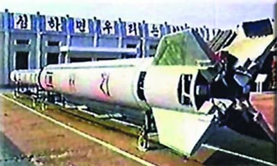
There is still an ongoing debate within the open source community as to whether or not the Safir was in a two- or three-stage configuration. An answer to this debate is crucial for an accurate assessment of how far the Iranian technology has advanced, as well as possible implications for their ballistic missile program. If only two stages were used to boost the satellite to orbital speed, it would mean that the Iranians had significantly advanced the existing improved SCUD technology used in the North Korean Nodong and Taepo dong families. If the Iranians have managed to improve upon the North Korean technology, then there is the possibility that they transferred the new technology back to North Korea. This could mean that North Korea is indeed going to attempt to launch a satellite and it is possible that they could succeed. Another significant question is whether or not China or Russia played a role in these improvements, contrary to the Iranian statements that they were purely indigenous accomplishments. Difficult questionsThe most honest answer to the question of whether or not the upcoming North Korean launch will be a ballistic missile test or an attempt to place a satellite in orbit is “yes”. Just like with many other space-related technologies, rockets are inherently dual use. They can be used for the most noble of peaceful purposes, such as lofting a satellite to monitor human rights violations, or the most evil, such as delivering a multiple megaton warhead to a major city. If the North Korean vehicle being prepared at Musudan-ri is used to place a satellite into orbit, it does not necessarily mean that North Korea will be able to turn that technology into a long-range nuclear delivery system. Much depends on the configuration of the launch vehicle and the types of storable propellants used. And until there is a successful flight of the vehicle from which good intelligence can be gathered, it will be almost impossible to answer this question. But it is certainly possible that a successful space launch will result in advances in their ballistic missile program. The commander of US Pacific Command, Admiral Timothy Keating, has indicated that the US missile defense system is once again active for the upcoming North Korean test. If the booster once again follows a due east course indicative of a space launch attempt, it is extremely unlikely that the US military will take action. But unlike the 2006 test, this time around Japan has announced that two of its Aegis warships will be in position to intercept the launch vehicle, should it pose a threat to Japan. Japan will have a much shorter timeline than the US within which to make this decision, and the implications of making the wrong decision could be disastrous. Home |
|

