Above the clouds: the White Cloud ocean surveillance satellitesby Dwayne A. Day
|
|||||||||||||||||||||||||||||||||||||||||||||||||||||||||||||||||||||||||||||||||||||||||||||||||||||||||||||||||||||||||||||||||||||||||||

| The evolution of this capability with the POPPY satellites, and the technology developments that led to PARCAE, is a story that is only now becoming public. |
But while this drama played out on, over, and under the waters of the Med, there was a much less visible sphere of operations far overhead of the two fleets, probably much farther overhead than the Soviets suspected. The concentration and activity of the Soviet Navy provided an excellent opportunity for American ocean surveillance satellites to demonstrate their capabilities in an activity known as HULTEC. HULTEC, which stands for hull-to-emitter-correlation, is exactly what its name implies: matching intercepted signals from radars and presumably radios to a specific maritime vessel and developing a “signature” for that vessel.
American aircraft, such as the ungainly EA-3B Skywarrior—better known as “the whale”—regularly flew off the decks of American aircraft carriers and intercepted the signals from Soviet warships, as did the land-based propeller-driven P-3 Orion. But satellites offered many advantages over aircraft for this mission. This included their ability to survey far more area from their high perch, and the fact that, unlike airplanes, they did not run out of fuel.
But the satellite ocean surveillance that the United States utilized in that tense period in 1973 was a relatively new capability for the United States. Although the US Navy had launched the first electronic intelligence (“elint”) satellite, named GRAB, in 1960, it was not until the late sixties that the United States intelligence community began to evaluate the ability of elint satellites specifically to intercept the emissions of naval vessels and use them to track those vessels. The first satellites to do this operated under the designation POPPY. But by the early 1970s the American National Reconnaissance Office (NRO) and the Naval Research Laboratory (NRL) were developing a new system known as PARCAE. The evolution of this capability with the POPPY satellites, and the technology developments that led to PARCAE, is a story that is only now becoming public.
A constellation of satellites
POPPY 6 was launched on September 30, 1969, and replaced POPPY 5 as the primary in-orbit collector. POPPY 6 had several improvements, including a wider frequency range. By late 1971 the POPPY satellites in orbit were showing their age. POPPY 5 was near the end of its lifetime, while POPPY 6 had suffered system degradations. POPPY 7 was launched on December 14, 1971, and operated until August 1977, and was undoubtedly one of the assets used to monitor Soviet naval vessels in the Mediterranean Sea in fall 1973. But by this time it was a mature system that was being overtaken by newer satellites.
The POPPY launches had all involved multiple satellites. Because the additional satellites on these launches were not always identified, independent observers initially speculated that POPPY was a multiple satellite system involving two or more satellites during each launch. Declassified documents have now demonstrated that this was not the case, and POPPY satellites were launched one at a time rather than in clusters. However, this raises the question of what the additional satellites were for. There are several indications from declassified documents that NRL engineers were already developing multi-satellite systems and operational techniques for an eventual POPPY successor as early as the mid-1960s. For example, Peter G. Wilhelm, who had been involved in the development of the micro-thruster, was also involved in something called “launch coordination” from 1966–1971, possibly indicating that starting in 1966 POPPY launches were coordinated with other satellites already in orbit in order to maximize their intelligence capabilities. Other NRL engineers developed other important capabilities. In 1966 Robert E. Daniels performed a “simultaneous illumination study.” And in 1962, Bassford C. Getchell had developed the “two-ball technique.” None of these innovations has been described in declassified documents, but they all imply the use of multiple satellites operating in concert to gather signals.
The May 1967 and September 1969 POPPY launches contained several satellites that remain classified. One possibility is that these were experimental elint payloads of a new design intended to be POPPY’s successor. Another possibility is that they were engineering development satellites to demonstrate new equipment that could be used for other elint missions, but did not possess the capability of collecting intelligence on their own. Because these launches carried a POPPY satellite, and because they were launched when the ocean surveillance mission had not been officially adopted for the next satellite mission, it is unlikely that these were prototypes for the successor.
But Frederick W. Raymond of the Naval Research Laboratory was involved from 1967–1977 in a “multiple satellite deployment and station keeping strategy.” The fact that Raymond was working on this in 1967, before the adoption of the ocean surveillance mission, is further indication that POPPY’s follow-on already included multi-satellite operations for operations against ground-based targets.
Lee M. Hammarstrom worked on “ocean surveillance augmentation planning” from 1970–1972. This is apparently a reference to developing means of increasing the ability of satellites to conduct ocean surveillance, presumably by putting more satellites into orbit.
In December 1971, during the last POPPY launch, three additional classified satellites were placed into orbit along with POPPY, and it seems possible that these were prototypes of the follow-on to POPPY. These satellites all reportedly included gravity gradient stabilization and may have been deployed using a new system for carrying the satellites into orbit. Declassified records indicate that 1971 was also the year that Peter Wilhelm and Frederick W. Raymond helped to develop the “multi-satellite dispenser.”
From 1971 until 1975 William P. Busch at the National Security Agency was involved in the development of “time-critical tasking” for signals intelligence satellites. It is unclear from available information what this was for, but one possibility seems to be that it involved making the POPPY follow-on system capable of identifying and tracking naval radar emitters faster so that the data could be relayed to US Navy ships at sea.
Ronald L. Potts of the Naval Security Group was involved in a HULTEC study from 1968-1970 and also was instrumental in developing a technique known as “delta time extrapolation,” as well as a distance calculator and latitude convertor.
| Clearly the development of an ocean surveillance capability must have been expensive, if only because the number of satellites required for the mission was much greater. |
There are numerous methods for determining the location of a radio emitter on the ground or at sea. One method commonly used in World War 2 was to use multiple receivers to take bearings on a signal and then draw lines on a map along those bearings—the lines would intersect at the location of the emitter. “Delta” is an engineering term meaning “change.” “Delta time extrapolation” may be another means of saying “time difference of arrival,” or TDOA, a technique that is commonly used for mobile phone networks. TDOA works by precisely measuring the difference in the arrival time of a signal received at several points based on the fact that a signal will arrive at a receiver closer to the emitter before it arrives at a receiver that is farther away. It requires precise timing by the receivers, but also communications between the receivers so that they can compare the differences. These requirements drive the technology, and for this reason the Naval Research Laboratory began working on highly precise clocks capable of being carried in satellites.
Although it remains unclear if the spacecraft launched alongside POPPY in 1967, 1969, and 1971 were prototypes for its successor, it does appear as if several new technologies were developed during this period. These include multi-satellite operations and gravity gradient stabilization. Both technologies would be employed by POPPY’s successor, as would delta time extrapolation.
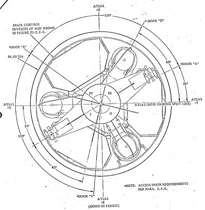 Schematic of the multi-satellite dispenser and its trio of PARCAE satellites developed by the Naval Research Laboratory in the early 1970s. (credit: USAF) |
Ocean surveillance transitions from experiments to operations
Clearly the development of an ocean surveillance capability must have been expensive, if only because the number of satellites required for the mission was much greater. Elint satellites in general could work at a leisurely pace, collecting data over a long period of time to use in such projects as planning routes for B-52 bombers to penetrate Soviet airspace in event of war, or the development of radar jammers and other electronic countermeasures.
But ocean surveillance was different. It was much more of an operational military mission. The data collected from an ocean surveillance system had to be immediately relayed to operators because the detected ships moved. In addition, the areas of interest were no longer confined simply to the Soviet Union, the Warsaw Pact, and China, but now included all of the Earth’s oceans. During the 1973 Mediterranean crisis the Soviet naval vessels were conveniently all bunched up in a relatively small area of ocean. But two years later the Soviets undertook a massive exercise named “Okean 75” involving warships spread all over the globe. It was an impressive demonstration of the improved capabilities of the Soviet Navy. And it meant that an American ocean surveillance system would have to surveil the Atlantic, the Pacific, and the Indian Oceans—a truly huge amount of the territory. In order to increase coverage, and to increase timeliness, the designers had to dramatically increase the number of satellites. Two POPPY satellites—the standard constellation during the 1960s—would not be sufficient for this new mission.
But new location techniques such as delta time extrapolation also increased the number of satellites required. Apparently a minimum of three satellites were required to achieve the degree of accuracy demanded by the ocean surveillance mission. As NRL engineers evaluated this new mission, they determined that ocean surveillance required the launch of at least three constellations of three satellites each—nine satellites versus the old requirement for two. Each constellation would be launched into a separate orbital plane. Add to that a requirement for a much more capable processing system on the ground, and at sea.
The available records on the transition to an operational space-based ocean surveillance satellite system remain somewhat murky. In 1970 the Chief of Naval Operations ordered a study of overall ocean surveillance requirements and the NRL responded by producing the Ocean Surveillance Requirements Study, a comprehensive five-volume report. One offshoot of the study was Program 749, a study for development of a series of high-resolution, phased-array radar satellites that would provide all-weather ocean surveillance as well as the ability to track Soviet cruise missiles. This was to be the American equivalent of the Soviet Radar Ocean Surveillance (RORSAT) program, although using solar power instead of the nuclear reactors that proved so problematic for the Soviet Union. Program 749, also known as Clipper Bow, did not progress far before being canceled.
In summer 1972, at the direction of its director, John McLucas, the NRO undertook a study of the role that satellites could serve in collecting tactical elint for ocean and battlefield surveillance. By autumn of that year, the Assistant Secretary of Defense for Intelligence, Albert D. Hall, contacted McLucas about conducting a study of the use of elint satellites for surveillance. McLucas saw no need for such a study, although he suggested that Hall instead address the interplay between satellites and more conventional systems, like aircraft.
| Although classified satellite code names are not supposed to give away their mission, PARCAE seems to be a clever exception. |
In late August 1973, Hall requested the Navy conduct a “comprehensive study of the entire U.S. ocean surveillance capabilities.” The study, which was to be conducted by the Center for Naval Analysis and would last two years, was approved by the Chief of Naval Operations. However, the Navy requested access to special controlled information associated with classified satellite systems and the NRO objected to granting access to those involved in the study. Furthermore, the NRO objected to such a study being conducted outside of the NRO itself. It is unclear if the study ever took place, but it is easy to imagine a bureaucratic struggle over control of this newly emerging ocean surveillance capability. The more the satellites were tied to naval operations, the more the Navy would want to control them as tactical assets rather than leave their control to the National Reconnaissance Office. The 1973 naval operations in the Med, however, undoubtedly highlighted the opportunities for using satellites to track naval vessels at sea.
PARCAE and the Classic Wizard
There were apparently no NRL elint intelligence satellites launched between 1971 and 1976. But in 1976 the NRL debuted an entirely new system known as PARCAE. Although classified satellite code names are not supposed to give away their mission, PARCAE seems to be a clever exception. In mythology, the Parcae were the three daughters of Zeus and the goddess Themida. One of the daughters spins the thread of fate for each mortal. The second daughter measures out a length of thread for each person. The third sister (appropriately named Atropos—“she from whom one may not flee”) cuts the measured thread of life. It was a truly clever name for a trio of satellites intended to cut short the lives of Soviet warships.
PARCAE had an unclassified cover designation, White Cloud, part of the Naval Ocean Surveillance System (or NOSS). The system was also given the overall name of Classic Wizard, which apparently referred to the receiving and processing systems. The Classic Wizard Operations Management Plan was first established in November 1973. Classic Wizard was described in Navy documents as “an advanced ocean surveillance system.”
PARCAE utilized the multi-satellite dispenser developed by Peter Wilhem and Frederick W. Raymond. The dispenser was launched atop an Atlas F rocket and would deploy the three satellites. Each satellite had six sides in a semi-pyramidal shape. The satellites deployed a gravity gradient stabilization boom out one side that caused them to orient themselves in a specific direction.
Whereas the existence of both GRAB and POPPY remained classified for nearly four decades, the existence of POPPY’s successor leaked to the press relatively early. In August 1971, Aviation Week & Space Technology reported that the US Navy was planning an ocean surveillance satellite. On May 10, 1976 the magazine reported that a late April launch of an Atlas F rocket from Vandenberg Air Force Base carried the “Navy’s first experimental ocean surveillance satellite,” built by the Naval Research Laboratory under the code name White Cloud. A follow-up article in June indicated that a main satellite had deployed three small sub-satellites into orbit, dispensing them into near-circular 700-mile (1,130-kilometer) orbits. The magazine also reported that each of the sub-satellites was “believed to carry an infrared/millimeter-wave sensor.”
A second set of ocean surveillance satellites was launched on an Atlas F in December 1977 into a similar orbit. By July 1978 Aviation Week reported that there were three satellites in each constellation, dispensed by a carrier vehicle. Each of the satellites was separated from the others by approximately 27 miles (43 kilometers) and was capable of detecting signals from a ship’s radar up to 2,000 miles (3,200 kilometers) away. According to the magazine, whereas the first two sets of satellites had been manufactured by NRL, production of the satellites had been turned over to Martin Marietta “under direction of USAF’s Space and Missile Systems Organization, with technical assistance provided by the Naval Research Laboratory.”
But the magazine’s real coup occurred on May 24, 1976, when the editors published a line drawing of the satellite. That line drawing is consistent with a series of declassified drawings dating from 1973 and depicting the Multiple Satellite Dispenser and outlines of the sub-satellites.
At some point the Navy developed the requirement for no more than a two-minute delay from time of observation to reporting to tactical users for early warning and targeting support. It is unclear how they achieved this impressive feat, but it apparently became the norm for the ocean surveillance system.
| Considering that many of the basic techniques of satellite ocean surveillance developed in the late 1960s and early 1970s are probably still in use today, it is likely that systems such as PARCAE will not be declassified for a long time. |
Between 1976 and 1987, the National Reconnaissance Office launched a total of eight PARCAE missions consisting of 24 satellites atop Atlas rockets to perform the ocean surveillance mission. This program was eventually phased out in favor of a presumably larger set of satellites launched aboard much more powerful Titan 4 rockets. Today Atlas 5 rockets carry a pair of satellites into orbit to perform the same mission.
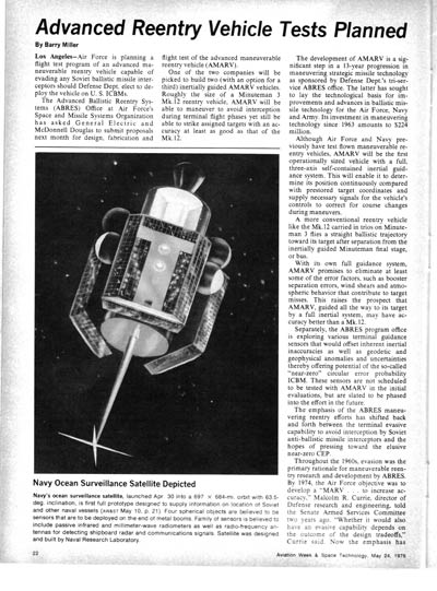 An Aviation Week article about the development of the ocean surveillance satellites. (view larger version) |
Prowling the oceans
It is common these days that whenever a new intelligence satellite is launched news reports claim that it is intended to play a major role in the ongoing war on terrorism. That is often an exaggeration, for many of these intelligence systems are better suited to monitoring more conventional adversaries than terrorist cells. This is probably truer for American ocean surveillance systems than other intelligence satellites, because al Qaeda lacks a navy. But ocean surveillance satellites still play an important role in tracking ships around the globe and keeping the United States Navy aware of the situation at sea. It was not until many decades after World War 2 that the importance and the details of allied signals intelligence in that conflict began to be known. Considering that many of the basic techniques of satellite ocean surveillance developed in the late 1960s and early 1970s are probably still in use today, it is likely that systems such as PARCAE will not be declassified for a long time. But be assured that their descendents continue to orbit silently overhead, their electronic ears listening for the faint electromagnetic whispers of ships at sea.
GRAB, POPPY and PARCAE Launches
| Date | Vehicle | Launch Site | Mission | Remarks |
|---|---|---|---|---|
| GRAB | ||||
| 22 Jun 1960 | Thor Able Star | CC | GRAB 1 | |
| 30 Nov 1960 | Thor Able Star | CC | Failure | |
| 29 Jun 1961 | Thor Able Star | CC | GRAB 2 | |
| 24 Jan 1962 | Thor Able Star | CC | Failure | |
| 26 Apr 1962 | Scout | NMFPA | Failure | |
| POPPY | ||||
| 13 Dec 1962 | Thor Agena D | VAFB | POPPY 1 | |
| 15 Jun 1963 | Thor Agena D | VAFB | POPPY 2 | |
| 1 Jan 1964 | TAT Agena D | VAFB | POPPY 3 | |
| 9 Mar 1965 | Thor Agena D | VAFB | POPPY 4 | |
| 31 May 1967 | Thor Agena D | VAFB | POPPY 5 | |
| 30 Sep 1969 | Thorad Agena D | VAFB | POPPY 6 | |
| 14 Dec 1971 | Thorad Agena D | VAFB | POPPY 7 | |
| PARCAE | ||||
| 14 Dec 1971 | Thorad Agena D | VAFB | ||
| 30 Apr 1976 | Atlas F | VAFB | PARCAE 1 | |
| 8 Dec 1977 | Atlas F | VAFB | PARCAE 2 | |
| 3 Mar 1980 | Atlas F | VAFB | PARCAE 3 | |
| 9 Dec 1980 | Atlas E | VAFB | Failure | |
| 9 Feb 1983 | Atlas H | VAFB | PARCAE 4 | |
| 9 Jun 1983 | Atlas H | VAFB | PARCAE 5 | |
| 5 Feb 1984 | Atlas H | VAFB | PARCAE 6 | |
| 9 Feb 1986 | Atlas H | VAFB | PARCAE 7 | USA 15, 16, 17, 18 |
| 15 May 1987 | Atlas H | VAFB | PARCAE 8 | USA 22, 23, 24, 26 |