Can the US really build a global persistent surveillance system?by Taylor Dinerman
|
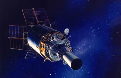
| The original SBIRS program was supposed to be even more multipurpose than the DSPs and was going to be the cornerstone of America’s future global surveillance system. |
While SBIRS High and the MEO ride-along sensor package are supposed to directly replace the DSPs, the 24-satellite SBIRS Low constellation was going to bring an order of magnitude improvement in America’s capability to track infrared (IR) signatures. The goal seems to have been to be able to track heat anomalies on the ground, in the air, and in low Earth orbit (LEO). This capability would have been truly revolutionary. Unfortunately, it seems that it was just too good to be true, at least at the cost that was estimated at the time. In February 2001, a GAO report estimated that four out of six critical technologies did not meet the critical technology readiness levels. It is significant that these all involved the IR sensor itself.
SBIRS Low, now called the Space Tracking and Surveillance System (STSS), has become a pilot project planning to launch two relatively small satellites some time in either 2008 or 2009. Its purposes will be, it seems, limited to missile defense and counterspace situational awareness. It will be interesting to see if the DoD has made any real progress since then.
Meanwhile, Congressional resistance to the Space Based Radar (SBR), sometimes also called the Space Based Ground Moving Target Indicator (GMTI) program, has remained strong. The Air Force has found it hard to get even minor technology demonstration programs approved. In part, this may be because some people fear that a successful SBR program would threaten not only the follow on to the JSTARS ground surveillance aircraft, called the E-10, but would even threaten the radar equipped UAVs, such as the predator and the Global Hawk.
UAVs and aircraft can get a lot closer to the object they wish to examine than can satellites, however, they are not only vulnerable to attack but, more often than not, they need permission from a foreign power to operate. They need land or sea bases and, even if they can stay aloft for days at a time, they can only keep an eye on one area at a time. A network of infrared and radar satellites in LEO could not only keep track of targets of interest in a given theater of operations, but would not need a new set of bases (and associated new set of political arrangements) every time the US government changed its intelligence gathering priorities.
It might be better to reexamine both projects and consider integrating STSS and SBR into a single project. This surveillance network would give its users, both operationally and at the national strategic level, a picture of world developments based on combined radar and heat signatures. When supplemented by the visual light images gathered by the FIA and commercial satellites, it would provide the US with a comprehensive view of what is happening all over the world. The military uses of such a system are obvious, but it could also be used to effectively gather economic and environmental data, or as a supplement to the satellite-based civilian search and rescue networks that are currently in use.
| No one knows where the next major crisis will break out. Ten years ago, few people in Washington had heard of the Darfur region or Kosovo or Najaf or Kandahar. |
The lack of a “footprint” and of a vulnerable logistics chain is another advantage of such a Global Persistent Satellite Network. The fewer Americans based overseas the better, and such a system would, over the long term, reduce overall personnel requirements. The main drawback would be the expense involved in bringing the IR, radar, and electric power systems to the required technology readiness levels.
Such a system would probably consist of at least fifty IR and radar satellites. It could downlink to both commanders in the field and even to aircraft in flight. In Washington, analysts could use massive data processing computers to study the output and would be able to supplement the original information with more detailed intelligence. This information could be formatted for use by both civilian and military leaders at different levels within the government.
No one knows where the next major crisis will break out. Ten years ago, few people in Washington had heard of the Darfur region or Kosovo or Najaf or Kandahar. Ten years from now, places like Urumchi or the Chittagong Hill Tracks or the Djado Plateau or Karaganda may be just as important The expense and difficulty of trying to constantly shift intelligence gathering assets to cope with new crises cannot be met with traditional “inside the atmosphere” systems. Integrated space-based global surveillance has got to be a medium- or long-term national goal.