GSAT-7A and India’s growing military space needsby Ajey Lele
|
| From the 1970s to the 1990s, Indian armed forces were dependent more on tweaking the available civilian data for their use. |
Countries like Japan, which have a limited security mandate, are keen to increase space-related military investments as well. The defense budget projections for the year 2019 by the Japan Ministry of Defense indicate that they are keen to establish cross-domain expertis, including space and cyber. The ministry is asking for significant funding for development of space situational awareness (SSA) systems and for strengthening of other space-supported systems. They also want to study a proposed space-based optical telescope to gather information about space debris and unidentified objects that fly around Japan’s satellites in geostationary orbit. Japan modified their national space policy in 2015 by adding a focus on security.
These broad global and reginal state-specific investments could be viewed as representative cases, in a limited sense, regarding how spacefaring nations are making investments in military space capabilities. India’s launch of a military communication satellite, GSAT-7A, on December 19 could be regarded as a continuation of this global policy and practice in some sense.
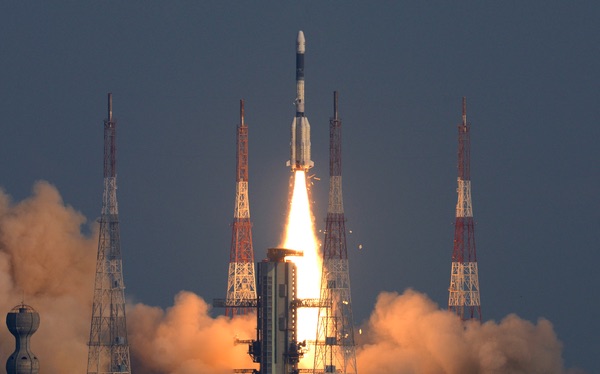
GSAT-7A is a geostationary satellite, located at 63 degrees east longitude, weighing 2250 kilograms with a lifespan of eight years. This satellite was launched essentially to cater to the requirements of the Indian Air Force (IAF).
Why is India investing in the military space domain and are these investments adequate?
India’s space agency ISRO, since its inception a half-century ago, has been tasked to undertake missions that clearly have a civilian and socioeconomic developmental mandate. India spends approximately 0.04 percent of its gross domestic product (GDP) in the space arena. ISRO’s initial focus was on launching multipurpose satellites. More recently, India has started launching satellites that are designated for specific purposes like remote sensing and communications. India has undertaken missions to Moon and Mars, but they were more of technology demonstration missions and carried only a small scientific payload.
Against this backdrop, India’s space program could be considered more modest in comparison with those of the US, Russia, China and Europe. However, this modest program is serving an economy that is the world's sixth-largest economy by nominal GDP and is the third largest by purchasing power parity. Its population is approximately 18 percent of the total world population. On a strategic front, India has major unresolved border issues with its neighbors, Pakistan and China, with whom it has fought five wars during last seven decades. India has the world’s second largest military force, with approximately 1.5 million personnel in active military service. India, Pakistan, and China are have nuclear weapons and missiles.
| Over the last decade, India has established one major constellation of satellites called Cartosat, which largely is known to have defense applications. |
Many space-based assets are known to be dual-use systems, including those operated by India. From the 1970s to the 1990s, Indian armed forces were dependent more on tweaking the available civilian data for their use. As India’s armed forces started modernizing and also as ISRO started transforming, military requirements also started becoming clearer. Like any other nation, it is obvious that the effective use of space technologies during the 1991 Gulf War must have influenced the Indian military thinking.
Since the 1980s, India has launched nearly 40 communications satellites, of which about ten are currently operational. However, the first communication satellite exclusively for military use was launched only in September 2013: GSAT-7, a multi-band military communications satellite developed by ISRO for use by the Indian Navy. There was a longstanding demand by the IAF for a satellite that GSAT-7A is designed to fulfill. GSAT-7A will provide services in Ku-band and offers a secure mode of communication expected to facilitate exclusive-frequency flight communications for the IAF. The IAF’s various bases are spread across India, including deserts, jungles and mountains. The Ku-band links are expected to offer uninterrupted connectivity that is less susceptible to disruptions caused by rain. This satellite will help IAF link its airbases, radar stations, Airborne Early Warning and Control System (AWACS) aircraft, and manage the activities of drones. India is expected to launch one or two more military communications satellites in the near future, with the Indian Army expected to be the next beneficiary.
Remote sensing is one arena where ISRO has developed significant expertise over the years. ISRO has more than ten operational remote sensing satellites currently, which provide data in a variety of spatial, spectral, and temporal resolutions. This information is used for many purposes, such as land and water resource management, drought/irrigation monitoring, urban planning, forest surveys, cop health monitoring, identifying mineral deposits, and coastal studies.
Some of these satellites also have a specific defense utility. On October 22, 2001, the Technology Experiment Satellite (TES) was launched was launched by ISRO. This satellite had a resolution of lesser than one meter. India’s pursuit to use satellite technology for defense in a very systematic way could be said to have begun with the launch of this satellite. Over the last decade, India has established one major constellation of satellites called Cartosat (cartographic satellites), which largely is known to have defense applications:
| Name of Satellite | Launch Date | Resolution | Remarks |
|---|---|---|---|
| Cartosat 1 | 5 May 2005 | 2.5 m | |
| Cartosat2 | 10 Jan 2007 | < 1 m | |
| Cartosat2A | 28 Apr 2008 | 80 cm | Perceived to be dedicated satellite for the Indian Armed Forces |
| Cartosat2B | 12 Jul 2010 | < 80 cm | |
| Cartosat2C | 22 Jun 2016 | < 80 cm | Used for weather mapping too |
| Cartosat2D | 15 Feb 2017 | < 80 cm | |
| Cartosat2E | 23 Jun 2017 | < 80 cm | |
| Cartosat 2F | 12 Jan 2018 | < 80 cm | |
| Cartosat3 | Proposed system | Expected to be around 30 cm | For land & infrastructure mapping, enhanced disaster monitoring, and damage assessment |
A few other important remote sensing satellites with dual-use capability include satellites in RESOURCESAT series (1, 2, 2A) and weather satellites like SARAL and Megha-Tropiques. Similarly, there are a few satellites are in the Oceansat 1 and 2 series as well as the Radar Imaging Satellites called RISAT 1 and 2.
However, India’s remote sensing satellite inventory is grossly insufficient for India’s needs. India shares borders with seven nations, starteching for more than 15,000 kilometers on land, as well as more than 7,500 kilometers of coastline. Although India has major challenges to manage its borders with Pakistan and China, keeping an eye on its other borders is also important. Most of these borders are open borders, and the intrusion of terrorists can take place from those regions too To have all-terrain, all-weather, continuous monitoring of these borders, India needs many more sophisticated remote sensing satellites.
| There is a case for India developing a global satellite navigational network, both for commercial and strategic reasons. |
In the arena of navigation, India has put in place an Indian Regional Navigation Satellite System (IRNSS) which is now called as NAVIC (NAVigation with Indian Constellation). This is a seven-satellite regional system, with all seven satellites currently in orbit. This system offers two levels of service, a “standard positioning service” for civilian use and a “restricted service” that is encrypted for for military use.
The military’s requirements for satellites are much more than what India has today. In the arena of satellite-based navigation, India seems to have taken the first successful step. NAVIC, when declared fully operational. would be able to largely serve India’s requirements. However, there is a case for India developing a global satellite navigational network, both for commercial and strategic reasons.
While India has no extraterritorial ambitions, and the basic job for the Indian armed forces is to safeguard its own borders, India wants to ensure a conducive security environment for making economic progress and maintaining social harmony. For this, India needs to ensure that there is safe access for global trade and management of energy security. Also, the humanitarian operations after the 2005 Asian tsunami, and anti-piracy operations off the coast of Somalia undertaken by the Indian Navy, highlight the need for India to remain prepared for any out-of-area contingency. The Indian diaspora continues to grow and ensuring their safety is important. In 2015, Indian armed forces undertook Operation Raahat to evacuate Indian citizens and foreign nationals during the Yemeni crisis. To undertake such delicate tasks, a satellite navigational system with global reach is essential.
Today, Indian armed forces are expected to remain prepared to handle asymmetric threats as well as conventional and nuclear warfare scenarios. In addition, there is significant dependence on military forces for disaster response management and to undertake out-of-area contingency operations when needed. Space is an important domain that would assist India’s armed forces to address all these challenges. Therefore, India needs to enhance its capabilities in space. More importantly, India needs to invest in systems beyond reconnaissance, navigation, and communications systems. India needs to expand its existing infrastructure and add signals intelligence satellites as well. India could also make greater use of small satellites. Overall, there is a clear need for India to increase its investment in the military satellite arena.
Note: we are temporarily moderating all comments subcommitted to deal with a surge in spam.