Spybirds: POPPY 8 and the dawn of satellite ocean surveillanceby Dwayne A. Day
|
| It has become apparent that this launch represented a significant turning point in the history of satellite signals intelligence, when satellites were no longer collecting data to be analyzed at a future time, but to be used in near-real-time, to support military forces. |
In 1963, POPPY 4 was launched, this time placing three satellites in orbit. The satellites were slightly larger in diameter than their predecessors: 24 inches (61 centimeters) in diameter with a central cylindrical band added giving the satellite a length of 81 centimeters. The three-satellite constellation was similar to the previous mission, but the larger diameter allowed them to carry additional equipment and enabled them to cover large frequency bands not covered by POPPY 3. POPPY 4 discovered new radars and frequency band usage by the Soviet Union.
Due to launch problems, the POPPY 3 and 4 missions did not achieve the precise orbits that their designers sought for operational purposes. But in 1964, the POPPY 5 mission achieved a near-circular orbit for the first time. It too carried three spherical satellites. In March 1965, an Air Force-launched rocket carried the POPPY 6 mission aloft. But at least one of the satellites suffered a battery problem that affected operations, although the details still remain classified 56 years later.
The POPPY satellites were intended to find “new and unusual” emitters, equipped with electronics that could scan widely, like a pair of binoculars searching the electromagnetic horizon.
The POPPY satellites were built by the Naval Research Laboratory (NRL) in Washington, DC. Although the NRL was a separate organization and part of the Navy, it also was a component of the super-secretive National Reconnaissance Office, or NRO, and the POPPY satellites were expressly built for the NRO, not the US Navy.
Early POPPY satellites were shaped like sphere halves with a cylindrical band between them, but as NRL engineers packed them with more electronics, they grew. NRL’s electronic wizards were constantly adapting the satellites to pick up new signals. Because the POPPY satellites were launched in a cluster, this enabled operators on the ground to measure the tiny differences in the time that signals reached each satellite to more precisely locate the emitter.
In mid-1966, the Johnson administration began pressing the intelligence community to locate the signals from anti-ballistic missile (ABM) radars. By this time the four satellites of POPPY 7 were nearly complete and scheduled for a February 1967 launch.
A special intelligence advisory panel named the Harry Davis Committee recommended modification of the satellites to improve the ABM search. An NRL official asked for permission to delay the planned POPPY 7 launch and modify the satellites to improve collection of ABM radar signals. This required equipment better able to detect the signals, more overlap in the suspected ABM frequency ranges, and upgrades to the ground system and recorders to improve quality. The head of the NRO granted the extension and NRL redesigned the satellites. These were the first multi-faceted satellites, significantly larger than their predecessors and able to carry more electronics. POPPY 7 was launched on May 31, 1967, and stayed operational for much longer than its predecessors.
In addition to the ABM mission, POPPY also apparently had a role in detecting and monitoring Soviet space tracking radars—in other words, the same radars that were monitoring POPPY as it flew overhead. American military and intelligence officials were concerned that the Soviets might try to attack American satellites, and understanding how they tracked satellites in space was an important aspect of this mission. A significant portion of the American satellite signals intelligence effort in the 1960s was devoted to determining the Soviets’ ability to spot American satellites overhead.
POPPY had what one historian described as an elegant system for sending its data to the ground. Unlike other satellites that recorded the intercepted signals and transmitted them back when over a ground station, POPPY sent the intercepted data directly down to a ground station, a so-called “bent pipe” design. The ground stations were located in friendly countries on the periphery of the Soviet Union and China, and most of the locations remain classified five decades later. But upgrades in the satellites by the mid-to-late 1960s were starting to swamp the ground stations in data. Although POPPY was a Navy program, the intelligence it gathered primarily benefitted other government agencies. The Air Force and National Security Agency (NSA) used POPPY’s data more than the Navy. But by the late 1960s several things happened that caused Navy officials involved with POPPY to ask if it could also serve naval needs.
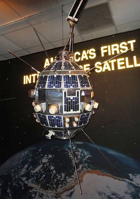 A POPPY satellite previously on display at the National Cryptologic Museum. This is probably a flight spare for the 1971 POPPY 9 mission. It differs from previous satellites by having a deployable solar panel at its top. POPPY was eventually replaced by a new system in the 1970s. (credit: Dwayne Day) |
A most dangerous game
In June 1967, the intelligence ship USS Liberty was attacked by Israeli warplanes, and in January 1968 the intelligence ship USS Pueblo was seized by North Korean naval forces and its crew held captive. In April 1969, a Navy EC-121M Warning Star—a militarized version of the lumbering four-engined Lockheed Constellation—was shot down by a North Korean fighter jet. Many US Navy personnel lost their lives in these incidents. Whereas the Soviet Union could generally be expected to act with some restraint regarding American intelligence collectors operating on the Soviet periphery, other nations were not so predictable. The Navy faced the difficult option of having to provide protection for its intelligence monitoring systems, or migrating at least some of their functions to safer platforms, such as satellites.
| Adapting POPPY to the new mission would significantly increase its cost. But the NSA produced a report that compared system productivity to cost, indicating that productivity was rising far faster than cost. |
Those events highlighted the dangers of human involvement in collecting signals, but there had already been a push within the naval community to expand the use of satellites. In 1967, a classified report suggested that the NRO should consider using satellites to track hostile ships at sea. POPPY had already produced a few intercepts of Soviet ships on the open ocean, but had never been specifically tasked with this mission. Soon the Navy began to experiment with POPPY. The details of these experiments remain classified, but they probably involved using American ships as test targets and determining POPPY’s ability to detect and possibly track them at sea. However, technical problems with the satellites made the tests inconclusive, undercutting the argument for using these vital assets for a new mission.
The POPPY 7 satellites had been modified to enable them to look for ABM radar signals, but they still had the capability to detect many other electromagnetic emissions. By December 1967 an experimental program involving the POPPY 7 satellites, apparently directed against the Soviet Fifth Eskadra Fleet in the Mediterranean (based in the Black Sea), began to produce results, and the Navy began work on a concept paper that outlined a plan for using satellites to locate hostile naval forces. This task expanded the number of different radar systems that POPPY had to detect, and many Soviet naval vessels were bristling with antennas. A short list of Soviet shipborne radars demonstrated how many of them there were. They had NATO designations like BALL GUN, BIG NET, GUN DISH, HEAD LIGHTS, HEAD NET, HIGH SIEVE, MUFF COB, POP GROUP, SLIM NET, TOP TRAIL, and TOP TROUGH. Perhaps some of the highest value targets were the SNOOP SLAB and SNOOP TRAY submarine-borne navigation radars which would have indicated where the subs were located.
By spring 1969, the proposal to use POPPY for ocean surveillance had worked its way up the chain of command. Adapting POPPY to the new mission would significantly increase its cost. But the NSA produced a report that compared system productivity to cost, indicating that productivity was rising far faster than cost. During the December 1967 test, POPPY had also improved targeting information instead of simply providing area reports of intercepted signals.
In June 1969, General Andrew Goodpaster, who was then the commander of US forces in Europe, formally requested all-source intelligence support to locate Soviet units of the Mediterranean squadron. The Soviet Navy had increased its operations in the Med, alarming NATO officials. Goodpaster’s formal request now provided the high-level justification for turning the POPPY experiments into an operational program for conducting ocean surveillance from space.
It is unclear if Goodpaster was prompted to make his request because he was aware of POPPY’s newly-developed capabilities to detect ships at sea. But the Mediterranean also had another feature that made it more suitable to early ocean surveillance efforts—it was surrounded by land. This meant that POPPY would be in range of American military facilities in places like Italy and Libya during its transits over the Med.
The POPPY satellites were intended to provide very accurate emitter location. No matter what part of the frequency spectrum it operated in, the POPPY system could provide about 10-nautical-mile (18.5-kilometer) diameter CEP for an emitter. CEP stood for “circular error probable,” meaning that approximately 50% of those emitters would be within a 10-nautical-mile circle and 50% would be outside.
In July 1969, the satellites were directed to “locate and report” elements of a Soviet naval force. The Chief of Naval Operations, Admiral Thomas Moorer, “was briefed periodically on the POPPY capability to identify and track ships at sea and on the results of these preliminary tracking exercises,” according to “The SIGINT Satellite Story,” an official history of US signals intelligence operations. On August 27, 1969, ocean surveillance became an official function of POPPY satellites, just before the most ambitious POPPY mission to date was about to fly.
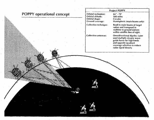 Declassified illustration showing how the multiple POPPY satellites could intercept radar signals from the ground or ships at sea. (credit: NRO) |
POPPY 8 prepares to fly
As of late March 1969, the launch date for POPPY 8 was planned for late May, but for unknown reasons the launch slipped, and by late June the satellites were scheduled for a mid-September launch. The satellites were to be placed in a 500-nautical-mile (926-kilometer) orbit inclined 70 degrees to the Equator. The mission was designed to “detect and transpond on a real-time basis to collection sites on the periphery of the Chinese-Soviet land mass pulsed emissions in the 154 to 10,000 MHz and 14.6 to 15.1 GHz frequency range with sufficient bandwidth to permit identification of frequency, pulse repetition frequency, scan rate, power and geoposition of the emitter,” according to a declassified pre-launch report on the mission.
| This was a true multi-organizational operation with the NRO office, which primarily consisted of Air Force personnel, providing the launch for the classified satellites built by the Naval Research Laboratory, which provided intelligence data primarily for the NSA and the Air Force. |
The POPPY 8 satellites were updated compared to previous missions. The ground stations included field digitizing equipment to increase processing accuracy of the collected data and enabled exploitation of data from all four satellites simultaneously versus only two satellites at the older analog recording sites. The POPPY satellites were to be spaced “to ensure accurate pulse time-of-arrival processing and permit illumination of all four satellites by a single emitter.” The mission lifetime was a minimum of one year.
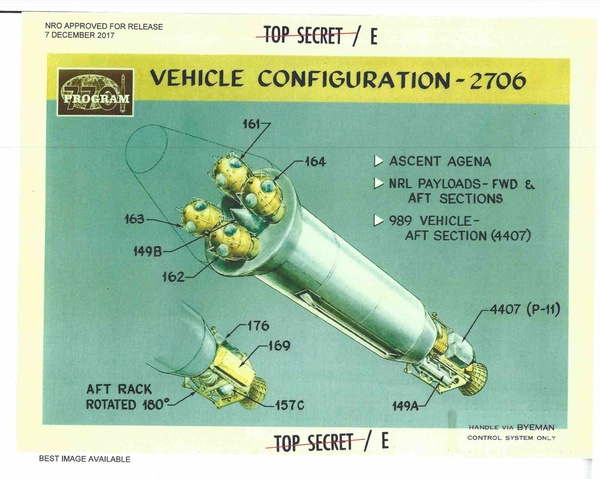
The satellites had a 12-sided multi-faceted shape. But compared to POPPY 7, they were increased three inches (7.6 centimeters) in height to accommodate the larger volume of electronics for the additional number of electronic intelligence collection systems. Collection antennas were located symmetrically around the polar axis at various latitudes of the spacecraft. There was also a turnstile array that deployed nearly straight down toward the Earth at the end of a four-foot (1.2-meter) boom. The turnstile antenna system served the two data link transmitters.
The satellites had a three-axis gravity gradient stabilization system that maintained the directional antennas of the ELINT collection systems aimed at the horizon and kept the solar panels pointing toward the sun. The satellites also had an ammonia vapor microthruster system that maintained spacecraft separation from each other.
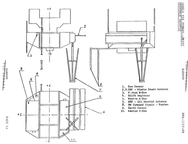 Recently declassified illustration of the WESTON satellite. WESTON was about the size of a suitcase and spun around its central axis. It had two primary targets, one of which was communications from Soviet SA-2 surface-to-air missile sites. Compared to POPPY, WESTON had a shorter lifetime and specific targets. (credit: NRO) |
WESTON, the other secret mission
The September 30, 1969, launch carrying POPPY 8 was conducted under the auspices of Program 770, a secret National Reconnaissance Office signals intelligence program that launched satellites into low Earth orbit equipped with various payloads for intercepting and identifying electronic emitters, primarily in the Soviet Union. Program 770 encompassed a lot of different signals intelligence missions, but the designation primarily referred to a series of large satellites based on the Agena upper-stage/spacecraft and operating in low Earth orbit and managed by the Air Force component of the NRO. The Los Angeles-based NRO office that managed these big satellites was also responsible for their launch vehicles, and in this capacity it handled launches for other classified payloads as well. This was a true multi-organizational operation with the NRO office, which primarily consisted of Air Force personnel, providing the launch for the classified satellites built by the Naval Research Laboratory, which provided intelligence data primarily for the NSA and the Air Force.
While the cluster of egg-shaped POPPY satellites could only fit at the Agena’s nose, they were light enough that the rocket could carry more payloads. Mounted to the other end of the Agena, on its aft rack just in front of the engine, was another satellite named WESTON. WESTON was about the size of a large suitcase, based upon the spin-stabilized P-11 satellite bus. By this time the NRO had flown nearly twenty P-11 type satellites, launching them off the back of Agena satellites carrying CORONA and GAMBIT reconnaissance cameras. The P-11 was a versatile design used to adapt to the changing electronic environment.
Five years earlier, in August 1964, a signals intelligence payload known as OPPORKNOCKITY had flown attached to the aft rack of an Agena spacecraft and operated for slightly less than two months. OPPORKNOCKITY was not entirely successful, however, because its receivers had been swamped by commercial television signals over Europe. WESTON was an improved version of that earlier payload, benefitting from the latest advances in electronics. According to a declassified National Security Agency history, a model of WESTON’s payload was successfully flown on an aircraft to prove its ability to conduct its mission.
WESTON apparently had been paired up with the POPPY 8 launch from the start, although its mission was not linked to the classified NRL satellites. WESTON had a planned mission lifetime of nine months, less than half POPPY’s lifetime. After separating from the Agena, the satellite would start spinning before a solid rocket motor would fire to place it in its proper orbit. The satellite was to operate in a 275-nautical-mile (509-kilometer) orbit, about half as high as the POPPY satellites. According to a newly-declassified report, WESTON was designed “to intercept, recognize, and record MERCURY GRASS and DAWN ROSE communications signals in the 60 to 70 MHz and the 360 to 420 MHz frequency bands.” WESTON would “measure the frequency and power of the intercepted signal,” but would not geolocate the targets.
MERCURY GRASS was a NATO reporting name for a truck-mounted communications system used by the headquarters of SA-2 Guideline surface-to-air missile emplacements to communicate with their battalions. At that time, the SA-2 was regularly shooting down American aircraft over Vietnam, and the US military was engaged in an exhaustive and fierce electronic battle to negate it. The Soviet DAWN ROSE communications system’s purpose is unknown, but it operated in the 360–410 MHz frequency band.
POPPY 8 operated sort of like a pair of binoculars, scanning the horizon looking for anything of interest in a broad frequency range and pinpointing their location, whereas WESTON was specifically focused on a couple of targets, seeking to learn as much as possible about how they operated, without concern about their location.
| WESTON and POPPY 6 began operating at a time when the ABM threat was much better understood—due in large part to their predecessors—and American signals intelligence satellites were beginning to serve tactical users in the Air Force and the Navy. |
WESTON may have been complementary to a little-known program that had been initiated a few years earlier designated PENDULUM. PENDULUM in some ways was the Air Force equivalent of what the Navy was trying to do with POPPY. It was an effort to use the ability of the larger Program 770 satellites to detect surface-to-air missile radars and feed their locations down to tactical airbases in South Vietnam so that American pilots could avoid the missile sites. WESTON, however, could not geolocate its targets, but the signals it collected could be used to better understand them, presumably to improve other systems that would have geolocation capabilities.
WESTON had two antennas, a UHF “oil derrick antenna” and a VHF “window shade” antenna, named for their appearance, and both stored in the same box on the side of the satellite. Two covers would be ejected off the box allowing the antennas to deploy. These antennas led to a UHF and two VHF superheterodyne receivers. The outputs of the receivers were recorded on tape recorders. When the tape recorders played back their information, the signals were analog-to-digital converted, enciphered, and transmitted to a tracking station in the United States.
The window shade antenna was deployed by centrifugal force as the satellite spun, and was 30 inches by 57 inches (76 by 145 centimeters) deployed. The oil derrick antenna was popped out of its box by a spring-loaded oil-damped actuator. It consisted of four fiberglass tubes forming the frame of a four-sided pyramid.
WESTON operated slightly longer than its planned nine-month lifetime, until August 1970. Due to continued classification, little is yet known about what WESTON accomplished in orbit. But WESTON and POPPY 6 began operating at a time when the ABM threat was much better understood—due in large part to their predecessors—and American signals intelligence satellites were beginning to serve tactical users in the Air Force and the Navy.
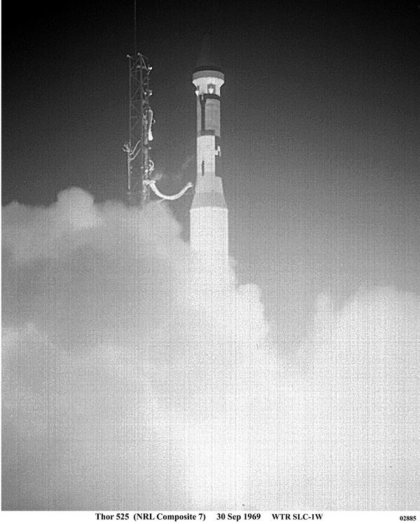 The only available photo of the September 30, 1969, Thor-Agena rocket launch at Vandenberg Air Force Base that placed a large number of satellites in orbit. Over half of the satellites on this mission were highly-classified, including the four POPPY 8 satellites and WESTON, as well as an additional still-unknown classified payload. In addition, the mission deployed radar calibration targets for space radars, and the experimental Timation 2 navigation satellite. (credit: Peter Hunter Collection) |
The fellow travelers
In addition to building highly classified signals intelligence satellites, the Naval Research Laboratory had been working on navigation systems throughout the 1960s, and in 1967 launched the Timation 1 satellite. Now Timation 2 was carried on board the POPPY 8 launch. Timation 2 had an improved clock synchronization and a larger power supply enabling continuous operation. Timation 2 used a passive ranging technique, which was combined with selected high-performance crystal oscillator clocks. This was intended to prove that a new navigational system that provided global three-dimensional coverage (longitude, latitude, and altitude) could work successfully. Not coincidentally, precise timing of signals was necessary for both POPPY and Timation 2, and NRL engineers were masters of that technology. Timation 2 led directly to the Global Positioning System (GPS) in widespread use today.
In addition to the POPPY and WESTON satellites, the launch also carried several other satellites as well. TEMPSAT 2 was a calibration sphere painted a specific color, apparently to test how that affected its radar cross section. Two other satellites were collectively designated SOCIAL. A cone-shaped satellite also designated payload 149B, was tucked in between the four POPPY satellites at the front of the spacecraft, and another cylindrical satellite designated payload 149A was mounted at the rear. Both were inflatable calibration targets for ground radars to track.
Finally, there was PL176 (for “payload”), a still-classified NRL experiment with a still unknown mission. PL176 remained attached to the Agena after all the other satellites had been ejected.
The actual operations of the classified missions remain secret over five decades later, but POPPY 8 was apparently very good at its mission.
POPPY’s legacy
According to an official NRO history, adding to POPPY the “the role of ocean surveillance late in 1970 fit in well with the interests of Navy sponsors.” But updated satellites represented only part of the story. Throughout the life of the POPPY program, the Navy and the National Security Agency introduced major upgrades to the POPPY ground stations. The ocean surveillance mission required getting ship location data to the Navy immediately, and so following the 1969 POPPY 8 mission there was a major effort to improve this ground station capability. According to an official history, in “September 1972 a further improvement in intercept capability occurred when the new POPPY Automated Processing System (PAPS) was added to” a ground station. This resulted in a higher processing volume, processing in “a continuous stream.” Two months later, the director of the NRO was shown how two Soviet warships were located and reported to the Navy very quickly.
The last of the POPPY missions, POPPY 9, was launched into orbit in December 1971. By this time, the POPPY satellites in orbit were showing their age. POPPY 7 was near the end of its lifetime, while POPPY 8 had suffered some degradations after two years in orbit. POPPY 9 would go on to last significantly longer than the predecessors, nearly six years, ending in 1977.
| POPPY 8 had led the way by becoming the first American satellite mission launched into orbit with the goal of detecting Soviet ships at sea. |
According to an official history, by 1975 the “low-orbiting POPPYs were busy searching for new signals and using their elegant relay techniques to provide the Navy, especially, with up-to-date locations of radar-equipped ships anywhere on the surface of the Earth. Going through a constant evolution from launch to launch, POPPY proved to be the best system for intercepting ship-based radars, which were sometimes only on for a few fleeting moments as the commanders used special tactics to avoid detection. This same main-beam intercept capability was immensely powerful in determining the power and scan properties of any ground-based radar that happened to illuminate the POPPY satellites. As a main-beam collector POPPY was the best” signals intelligence satellite system then in operation by the United States.
But by the time that POPPY 9 launched, a follow-on system was already in the works (see “And the sky full of stars: American signals intelligence satellites and the Vietnam War”, The Space Review, February 12, 2018). Known as PARCAE, with the unclassified cover designation White Cloud, and part of the Naval Ocean Surveillance System (or NOSS). PARCAE used the techniques that were perfected by the still-enigmatic POPPY missions. POPPY 8 had led the way by becoming the first American satellite mission launched into orbit with the goal of detecting Soviet ships at sea.
Note: we are using a new commenting system, which may require you to create a new account.