Strategic geographical points in outer spaceby Matthew Jenkins
|
| Establishing a “topography” for space now enables strategists to apply traditional geographic terms to elements of that topography. |
Strategists and historians have more recently explored additional subgenres of geography in statecraft to include economic, cultural, and human geography and how these geographical factors impact statecraft. In this modern age, the study of geography in statecraft and international politics must be expanded once again, requiring a more nuanced look at space geography. Unique to space strategy, all exoatmospheric locations can be used for civil, commercial, or military purposes. This plurality of use creates unique challenges for space operations that have, since the 1940s, driven successive US presidential administrations to treat space policy different than other elements of statecraft. This paper first provides a conceptual framework and vital definitions, then leverages these definitions to explore vulnerability vectors in orbit that are exploitable by any space power.
Defining the environment
Any discussion on space geography has to begin by bounding the scope and applying traditional geographic concepts to this seemingly unique domain. While space itself appears endless, when it comes to geography and strategy, it is relatively limited. More specifically, the practical portion of space for humanity is limited by both modern technology and time. Earth’s orbit is where most human activity occurs and therefore is of the most strategic importance to military strategy and statecraft.
To states, the most critical space topography in Earth’s orbit is the gravity well. A gravity well is a surface of revolution formed by rotating a suitably shaped curve around a central vertical axis, sweeping out an axisymmetric surface resembling the bell mouth of a horn.[1] This may sound intimidating, but we’ve all seen them. If you walk through any mall and some museums, you’ll see the horn in which you insert your penny and watch it spin around until it reaches the bottom and you’ve made your donation. You might know them as a vortex wishing well and the application provides a unique visual expression for Newton’s laws (Image 1 below.)[2] The critical takeaway is that gravity wells provide a visual geographic reference enabling strategists to conceive space geography in a way similar to traditional geographic features.
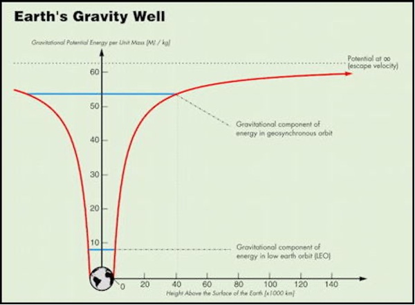 Image 1: Earth Gravity Well |
Establishing a “topography” for space now enables strategists to apply traditional geographic terms to elements of that topography. Referring back to image one, Earth is at the bottom of a gravity well and escaping the well requires an increasingly large amount of energy until reaching the crest. In low Earth orbit (LEO), the altitude can range from as low as 200 kilometers up to 2,000. Atmospheric drag is the highest in LEO, and as a result, remaining in this orbit requires the most energy of any orbit. Moving to increasingly higher orbits requires more energy but, once reached, requires less energy than LEO to remain in orbit. The differing energy requirements create geographical points that provide strategic advantages to nations with the intent and capability to exploit them.
| Much like sea lines of communication, space has natural lines of communication from terrestrial points to orbit. |
The gravity well model highlights the vulnerabilities in the topography of Earth’s orbit and the strategic implications of maintaining space-based capabilities. The deep part of the well, LEO, is the most used and the most vulnerable. Low Earth orbit is increasingly congested, making operating there more complicated than it has historically been. At the same time, the shallow parts of the well, at geosynchronous orbits (GEO), and beyond are relatively low threat areas but require substantially more energy to get there. In GEO (approximately 35,786 kilometers altitude), a satellite’s orbital period equals one revolution of the Earth, making it appear as if the satellite is fixed relative to the Earth’s surface.[3] This relationship places a premium on orbital locations there, which can provide 24/7 telecommunications fixed contact.
Terms of reference
Having identified a conceptual framework and some of the associated constraints for maneuvering in space, strategists can layer terms and features of traditional military terrains to this domain. To begin, space is replete with strategic positions, which impart some relative advantage from operating there or hold value due to the importance of the activities performed at the position.[4] As a subset of strategic positions, the first and most important is lines of communication. British naval historian and geostrategist Julian Corbett provides a maritime definition for lines of communication “as the waters over which passes the normal course of vessels proceeding from the base to the objective or the force to be supplied.”[5] Though the concept of lines of communication is not unique to the maritime domain, the fact that both friendly and adversary navies utilize a single line of communication simultaneously makes it unique in traditional military geography, but very similar to space-based military geography.[6] Like the maritime domain, friendly and adversary nations utilize all orbital regimes concurrently and, at times, in close proximity to each other.
Much like sea lines of communication, space has natural lines of communication from terrestrial points to orbit. These lines come in physical forms and non-physical forms. Dr. John Klein tweaks the definition of sea lines of communication and provides a space-based equivalent. He defines celestial lines of communication (CLOCs) as those lines of communication in, though, and from space used for the movement of trade, material, supplies, personnel, spacecraft, electromagnetic transmissions, and some military effects.[7] In essence, there are two lines of communication leveraged by adversaries and friendly forces. One CLOC involves radio frequency communications and one CLOC that involves getting satellites to orbit.[8]
The next geographical term to explore for application to space geography is common to land operations: the high point or high ground. The high point provides a unique and advantageous view of the surrounding terrain and allows the strategist to plan optimal defensive positions and fields of fire. In space, the benefit is similar. From high altitudes, satellites can maintain a constant eye and ear on Earth. This capability allows no gaps for exploitation and serves to facilitate almost instantaneous communication of information. Most countries use the GEO high point to place telecommunications and intelligence, surveillance, and reconnaissance satellites precisely because of this advantage. While it takes substantially more energy to escape to this distance of the gravity well, it is a relatively low expenditure to remain there. As such, satellites can operate for more extended periods of time when compared to satellites operating in LEO.
The final term for consideration as it relates to military geography is the choke point, which for space, is most applicable when transitioning space-based assets from LEO to GEO. Conventionally conceived, choke points are those intersections of lines of communication, such as maritime straits and isolated or low-density airfields. Naval strategists Rear Admiral Alfred Thayer Mahan and Julian Corbett both understood that defending sea lines of communication required access to deepwater ports. The ability to replenish supplies, fuel, and weapons before venturing back out to the open sea to defend maritime commerce and activity was the central role of the navy, as they understood it. Corbett noted that “the object of naval warfare must always be directly or indirectly either to secure the command of the sea or to prevent the enemy from securing it.”[9] It is easy to translate this requirement for space systems as well. While terrestrially based, the space launch complexes [spaceports], similar to deepwater points for the navy, are singularly focused on delivering satellites to orbit, making these launch complexes choke points in the space environment.
Points of exploitation
Using the previous terms of reference to define the geography of space, as it relates to traditional military geography, illuminates the geopolitical considerations space powers leverage when competing for advantageous geographic positions in the space domain. These positions can include CLOCs such as a geosynchronous orbital node that provides access to a given point of the Earth or a node that provides access to a part of the electromagnetic spectrum with the frequency and bandwidth to operate a satellite most effectively. This issue is of such importance that states with a powerful presence in space have actively sought to extend their sovereignty as far out as GEO. Specifically, in an effort to preserve their interests from encroachment by developed space powers, the equatorial countries have claimed to extend their national jurisdiction to the part of the geostationary orbit situated above their territory.[10]
| Few state actors have the capability to engage space assets directly whereas spaceports are substantially more vulnerable to human action. |
Regarding choke points, Klein makes a compelling case that LEO has already reached a critical level of density and is a choke point for all space systems. As of April 30, 2021, there were a total of 4,084 satellites in space, of which 3,328 were in LEO.[11] While a substantially larger physical space, GEO is heavily desired for communication, weather observation, and surveillance and is becoming increasingly congested as more nations advance space-based capabilities. In late 2020, 562 satellites were in GEO.[12] Since 90% of today’s operational satellites operate in one of these two orbital regimes, an active attempt at blocking access to these two orbits would create an exploitable geographic advantage that could result in political reprisals or even a military response.[13]
Choke points are of critical strategic importance in any domain when they lie along the key lines of communication. In traditional military geography, the choke point must be a position enabling an actor to control a line of communication or, ideally, an intersection.[14] With regards to CLOCs, points along the orbital plane optimized for transmitting data back to Earth or points optimized for orbit changing are naturally exploitable positions. If a ground station could not reach a satellite, the satellite would go into “safe mode” and become effectively useless for operations. Conversely, if operators seeking to raise a satellite’s orbit could not do so, a multi-billion dollar satellite could be left in a position that negates its intended use or at least de-optimizes the investment. In both scenarios, a state could create real world, adverse effects on adversary nations leveraging hard power techniques without actually leveraging any kinetic capabilities.
Similar to deepwater ports to the navy, spaceports represent the most physically vulnerable choke points to established and burgeoning space powers. Equatorial launch positions on Earth have an advantage over others due to the positions’ efficiency in launching satellites into orbit.[15] This efficiency exists because the closer a launch site is to the Equator, the greater the velocity assist provided to the launch vehicle from the Earth’s rotation when launching eastward. Other launch sites exist, but the distance from the Equator requires relatively more energy to deliver to the same orbit. For example, in the United States, there is only one major GEO launch site, Cape Canaveral, Florida, create a terrestrial vulnerability for US space capabilities. Few state actors have the capability to engage space assets directly whereas spaceports are substantially more vulnerable to human action. Sabotage, espionage, or even kinetic strikes could disable spaceports and render a state unable to sustain its orbital constellations.
What’s next?
The gravity well model is scalable beyond the Earth’s well, which created the strategic points and congestion in LEO and GEO challenging the interaction of current and burgeoning space powers. Moving further from the Earth, larger bodies (i.e., the Sun) dominate the gravitational interactions. The United States and other countries are examining ways to leverage this gravity well beyond GEO. Space strategists are already beginning to conceptualize dominance in cislunar space, the entire sphere of space from the Earth and extending past the Moon’s orbit to the Earth-Moon Lagrange point 2 (L2).[17] In 2020, the US Space Force signed an MOA with NASA, identifying areas of partnership that included deep space survey, extended space domain awareness, and “capabilities and practices enabling safe, sustained near-Earth and cislunar operations.”[18] Additionally, United States Space Command is in discussions with NASA to conduct a “planetary defense missions” demonstration with the Double Asteroid Redirect Test (DART) program.[19] The mission objective is to collide with an asteroid to study the impact, with the idea that it could influence an asteroid’s trajectory enough to avoid a potential collision with Earth.
| The states that best understand the vulnerabilities and benefits of the various points while minimizing risk to their space systems, and other states, are best suited to secure command of space’s global commons. |
Space powers are already exploring capabilities to exploit an expanded space domain leveraging strategic points in space geography to create a decisive advantage. The Earth-Moon Lagrange points L1-L5 (Image 2 below) are inherently unstable but are where the gravitational pull of two celestial bodies precisely equal the centripetal force required for a small object (e.g., a satellite) to move with them.[20] These points are valuable because once an object is placed there (or in a quasi-stable halo orbit around these points), it requires significantly less fuel to stay in position, thus potentially increasing the life of the asset by years. China has already placed a relay satellite in a halo orbit at the Earth-Moon L2 Lagrange point. As a result, it is essential for the United States to be clear in the message and its actions to develop a more comprehensive understanding of the space domain out through cislunar space.
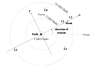 Image 2: Cislunar Map Illustrating the Circular Restricted 3-Body Problem |
The United States is already using other Lagrange points to its advantage. The Solar and Heliospheric Observatory Satellite (SOHO) enables studying the Sun and orbits around the Earth-Sun L1 point, one of several space science satellites there. NASA’s James Webb Space Telescope will one day call the Earth-Sun L2 point home.
For the Earth-Moon system, L3 is not in use, with no current plans to be. However, with L3 rotating about the Earth with regard to the sun every 27 days on the opposite side of the Earth from the moon, it could provide a “strategic high ground” effect like L1 and L2. L4 and L5 have future use potential as well. Earth-Moon L1 and L2 may become increasingly important as transport gates to the Moon in the near future. Each space power will seek to exploit these positions and their natural benefits, which inevitably creates a chance for conflict—or cooperation.
In summation, while not as easily translated as a map, space has natural geography. As more states venture into the cosmos, this geography becomes progressively crucial to national security and international relations practitioners. Using a gravity well model as the geographical, conceptual framework, one can naturally overlay strategically important and standard military geography features to the space domain. States must take great care to engage in diplomatic discourse to ensure access to and use of space endures. The US Defense Secretary took an unprecedented first step in July 2021 by laying out tenets for responsible space behavior. Now is the time for space practitioners to leverage the momentum and get serious about normal behavior related to space geography. These strategic points are invaluable to global economies, precision timing, and even military operations. As the realist school of international relations suggests, these points will become directly contested in the near future. The states that best understand the vulnerabilities and benefits of the various points while minimizing risk to their space systems, and other states, are best suited to secure command of space’s global commons. On a time scale, it is imperative to sort out geostationary and below in the near term. Having mastered that, the concepts can be scaled to strategic points in cislunar space, as the total volume is too large to “control.” Having developed a cursory understanding of the strategic points, analysts can begin to evaluate relative strategies to achieve their strategic goals in space by leveraging its geography to their advantage.
Endnotes
- Keith J Mirenberg, “VISUAL INSIGHTS TO SPACETIME AND GRAVITATION,” n.d., 3.
- “UG101: Recycling the Universe,” accessed June 13, 2021.
- Note: In this work, while there are differences, the terms Geostationary and Geosynchronous are used synonymously.
- John J. Klein, Space Warfare: Strategy, Principles, and Policy, Space Power and Politics 1 (London; New York, NY: Routledge, 2006), 81.
- Corbett, Some Principles of Maritime Strategy (London: Longmans, 1911). The latest edition, edited by Eric Grove, was published by the Naval Institute Press in 1988. All references in this paper are to the 1988 edition, 335.
- Alfred, Mahan, (National Review, vol. 39 (July 1902), 701-19. Reprinted in “Retrospect & Prospect” (Boston, 1902), 292.
- John J. Klein, Space Warfare, 51.
- Ibid.
- Corbett, Some Principles of Maritime Strategy (London: Longmans, 1911). The latest edition, edited by Eric Grove, was published by the Naval Institute Press in 1988. All references in this paper are to the 1988 edition, 91.
- Nicolas Giacomin, “The Bogotá Declaration and Space Law,” Space Legal Issues (blog), December 4, 2019.
- “Satellite Database | Union of Concerned Scientists,” accessed June 21, 2021.
- Ibid.
- Ibid.
- Ibid.
- John J. Klein, Space Warfare, 85.
- For example, the European Space Agency’s launch site at Kourou (4 degrees N latitude) gives launch vehicles an assist of 0.464 km/sec versus 0.4087 km/sec for the Kennedy Space Center at 28.5 degrees latitude.
- “Dickinson Calls for International Norms in Space, Citing ‘Provocative’ Actions by Adversaries”, Air Force Magazine, Aug. 3, 2021.
- Memorandum of Understanding between The National Aeronautics and Space Administration And The United States Space Force, retrieved on 26 June, 2021.
- Smith, Marcia, USSPACECOM TO SIGN MOA WITH NASA INCLUDING COOPERATION ON PLANETARY DEFENSE, spacepolicyonline.com, accessed June 21, 2021.
- M J Holzinger, C C Chow, and P Garretson, “A Primer on Cislunar Space,” May 3, 2021, 6, retrieved 4 Aug, 2021.
Note: we are using a new commenting system, which may require you to create a new account.