Dark Clouds: The secret meteorological satellite program (part 4)The Air Force finally gets its weather satelliteby Dwayne A. Day
|
| One of the team’s conclusions was that the current lifetimes of satellites in orbit along with delays in the Block 5D-1 program would result in a gap in meteorological satellite coverage by the end of the decade. |
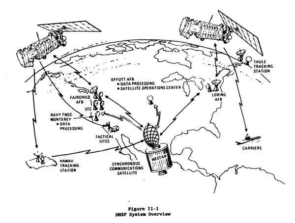
The geostationary satellites provided broad-area coverage while the civil and military polar orbiting satellites provided more detailed and high-resolution coverage. A geostationary satellite could track a hurricane far out at sea, while the polar satellites provided data on localized weather conditions. The two types complemented each other, and the military and civil agencies shared their data.
In January 1975, delays in the Block 5D-1 program led the Air Force Systems Command to send an Inspector General’s team to examine the DMSP program. One of the team’s conclusions was that the current lifetimes of satellites in orbit along with delays in the Block 5D-1 program would result in a gap in meteorological satellite coverage by the end of the decade.[37]
Even before that ominous future, a series of unfortunate events, including the loss of the last 5C satellite during launch in early 1976, resulted in poor DMSP weather coverage between 1975 and 1976. The program was demoted from “fully operational” to “partially operational.”[38]
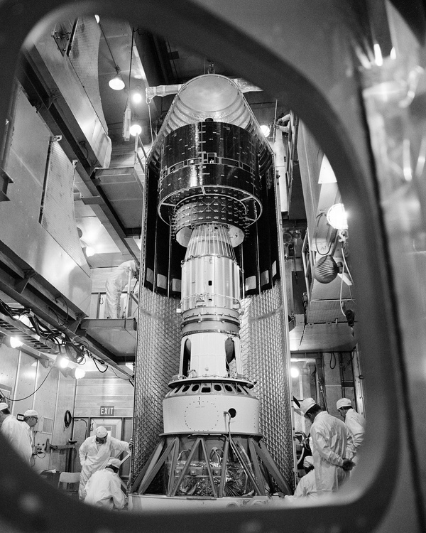
 The Block 5D-1 satellites were significantly larger and heavier than the Block 5C satellites. They housed their electronics in a boxy center section equipped with 1-2 louvers that could be opened to control internal temperatures. The first was launched in 1976 and the fifth, and last launch was in 1980, failing to reach orbit. (credit: USAF) |
After two years of delays, the first Block 5D-1 launched on September 11, 1976, but soon after reaching orbit began tumbling end-over-end due to what was later determined to be a nitrogen leak.[39] The tumbling prevented the solar panels from charging the batteries and eventually they died and the satellite went dormant. After a few weeks, the satellite was oriented at the right angle to recharge its batteries enough for ground controllers to reestablish communications. They were able to slow its tumbling and stabilize it. After the satellite was recovered, it was nicknamed “Lazarus.” The satellite eventually operated for 880 days. Despite its early troubles, the satellite had greatly exceeded its 18-month design lifetime.[40]
The problem with the first satellite resulted in hardware modifications and additional testing for the second satellite, delaying the launch by another six months. The second Block 5D satellite was launched in June 1977.[41] Launch delays resulted in the satellite being placed in an improper orbit and it soon drifted out of its position. The OLS data was not useful for the National Reconnaissance Office, which still needed good cloud coverage data over the Soviet Union to program photographic passes for its reconnaissance satellites.
During 1975, 1976, and the first quarter of 1977, the operational performance of the DMSP system was worse than it had ever been, resulting in complaints from the Air Weather Service and the Navy. To partially alleviate the problem, DMSP tactical ground sites were modified to receive NOAA-4 and NOAA-5 civil satellite weather data, which was not as good as the military data.[42]
The Space and Missile Systems Organization had a policy of waiting until a satellite failed in orbit before launching a replacement. But because it took almost two months to ready a satellite for launch, this led to degraded customer support. Fortunately, satellites launched in April 1978 and June 1979 operated properly. The 1979 satellite, Block 5D-1-4, operated for 430 days.[43]
Throughout this time, DMSP was the only Air Force space program where the spacecraft was launched by a crew of Air Force personnel rather than contractors, a source of pride within the service.
| Almost as soon as DMSP had gone public, pressure had increased to merge it with its civilian counterpart. |
The first Block 5D-1 satellite had operated successfully after being saved from its early death tumble in 1976. It stopped operating in September 1979, and by December the third satellite stopped operating as well. By March 1980, the second satellite also failed. The fourth vehicle began experiencing electrical problems in 1979 and at the end of December it was placed in “backup mode.” The civilian TIROS-N satellite failed in January 1980, leaving NOAA-6 as the only operational polar-orbiting weather satellite.[44] Although they were considerably more capable and had increased redundancy, the lifetimes of these satellites were often lower than the Block 5B and 5C satellites that they replaced.[45]
With the Defense Meteorological Satellite Program now relying on NOAA’s single operational satellite, the national weather satellite program was in an unhealthy state. The replacement Block 5D-2 satellites had slipped their schedule, meaning that any problems with the 5D-1 satellites could have a domino effect, opening up further gaps in coverage in the future.
The fifth DMSP Block 5D-1 satellite had been held in storage on the ground and was now readied for launch. Because of development delays for future satellites, it was vital that this satellite reach orbit and take over the mission for the next several years.
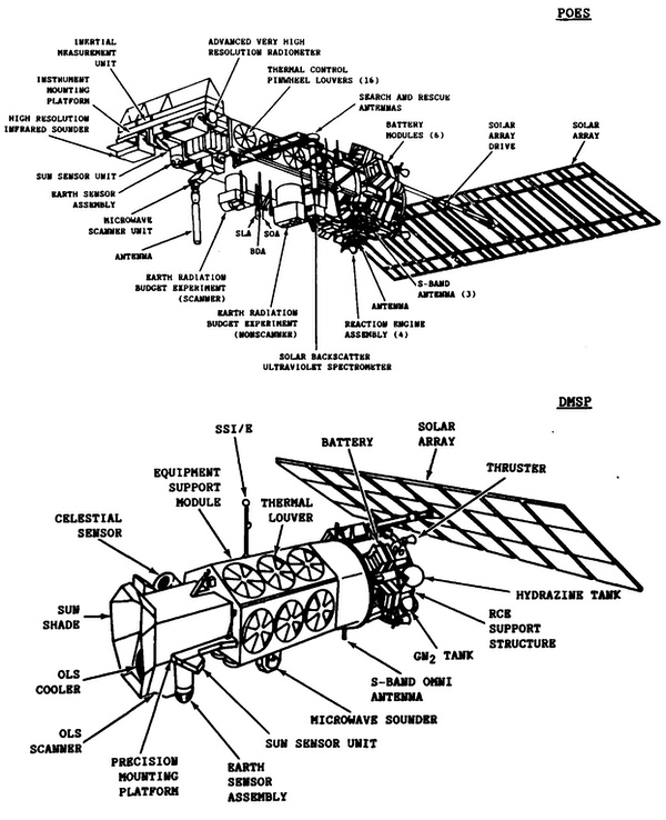 Comparison of the DMSP Block 5D-2 and the NOAA Polar Orbiting Environmental Satellite (POES). Both satellites were built by RCA, but had significant differences. There were several proposals during the 1970s and 1980s to merge the military and civilian polar orbiting meteorological satellite missions, but they were rejected. (credit: NOAA) |
Merging the civil and military polar-orbiting programs
Although the Air Force was responsible for the problems with DMSP that resulted in a severe reduction in weather data availability by 1980, there had long been external pressure on the program. Almost as soon as DMSP had gone public, pressure had increased to merge it with its civilian counterpart.
In October 1970, the National Oceanic and Atmospheric Administration (NOAA) was established within the Department of Commerce. NOAA was responsible for operating civilian weather satellites, although NASA was placed in charge of overseeing their procurement. In 1972, the Office of Management and Budget requested that DoD and Commerce examine consolidating civil and military polar orbiting weather satellite programs and using a single satellite type for both missions.
The DMSP Block 5C, in service at this time, already exceeded the capabilities of the planned NOAA-N satellite. A steering group made of representatives from NASA, NOAA, and the DoD suggested using the planned DMSP Block 5D as the basis for a single consolidated weather satellite program. President Nixon’s national security advisor, Henry Kissinger, rejected the recommendation, stating that it would violate the National Aeronautics and Space Act. Representatives of the Department of State also argued against the idea, which they believed would have international repercussions because NOAA weather data was shared with foreign governors.
In response, NRO Director James Plummer led discussions that resulted in an agreement to adopt an updated variant of the DMSP Block 5D satellite bus for both the civil and military missions. The Air Force would continue to operate its own satellites and NOAA would operate its own version of the Block 5D known as the National Operational Environmental Satellite System (NOESS) carrying civilian sensors and replacing the NOAA-N. This updated military version was designated as Block 5D-2, with the first five 5D satellites becoming Block 5D-1.[46]
In 1975, the Air Force contracted RCA to produce the Block 5D-2. The requirement to accommodate both military and civilian sensors introduced more complexity to the satellites. The satellites would also be heavier, requiring a larger booster, and the Air Force took a long time to settle on a solution. The DMSP program office decided to slip the first 5D-2 launch from 1980 to 1982.
But the problems were not only with the satellite. Between 1975 and 1980, there were six program managers assigned to the Block 5D program—a much less stable management environment than when Tom Haig had run the weather satellite program within the NRO for its first four years. The satellites’ costs rose, and in part because the satellites were supposed to have longer lifetimes, OMB and Congress reduced the number on order from 13 to 9.[47]
In June 1979, NOAA launched the first of its satellites based upon the DMSP Block 5D bus. Designated NOAA-A before launch and NOAA-6 upon reaching orbit, the satellite operated until being relegated to a secondary status in 1984. However, in late June of that year, after another NOAA satellite failed, NOAA-6 was returned to full operational status and continued in that role until it was decommissioned in March 1987 after nearly eight years of service.
In 1979, probably prompted in part by the debut of the new NOAA satellite, the Office of Management and Budget again proposed merging the military and civil low Earth orbit weather satellite programs like it had done seven years earlier. This move was opposed by both the DoD and Department of Commerce. President Jimmy Carter overruled his OMB and ordered that the programs remain separate, at least until future satellite block changes could merge them.[48] The Presidential Directive/National Security Council-42 “Civil and Further National Space Policy” directed OMB to conduct an examination of the civil and military programs to determine if there was a possibility to improve efficiency and save money.[49]
Over subsequent years there were multiple additional studies of merging the civil and military polar-orbiting weather satellite programs. Occasionally, members of Congress raised the convergence issue during appropriations hearings. But the issue primarily arose within the executive branch.[50]
A coordinating board of civil and military officials involved in polar orbiting meteorological satellites concluded in March 1979 that the best approach was to replace the two civil and two military polar orbiting satellites with three larger satellites that served both civil and military requirements.[51]
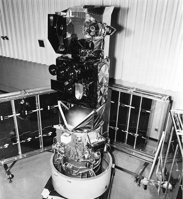 The Block 5D-1 satellites were five times as long and twice as heavy as their predecessors. They carried more instruments and had more capable systems. Originally planned for launch in 1974, they slipped to 1976. Despite a goal of outlasting their predecessors in orbit, they underperformed. (credit: USAF) |
Defense Secretary Harold Brown insisted that DMSP be augmented to support civil requirements, and DoD would have overall management authority. NASA and the Department of Commerce objected, arguing that a consolidated system would compromise existing weather satellite data sharing agreements, and ran counter to a strict interpretation of the National Aeronautics and Space Act of 1958—the same argument used by Henry Kissinger in 1972.[52] It seemed that whenever somebody proposed merging the civil and military systems, one of the major points of contention was over which side would have control: the military objected to civilian control, and the civil side objected to military control. The status quo proved to be the least objectionable choice for both sides.
Commerce proposed continuing the two separate systems but more vigorously pursue joint development and procurement of spacecraft and sensors. Later in the year, DoD, Commerce, and NASA demonstrated that the existing systems approach was cheaper than the new approach of using three, larger satellites.[53]
| It seemed that whenever somebody proposed merging the civil and military systems, one of the major points of contention was over which side would have control: the military objected to civilian control, and the civil side objected to military control. |
In 1978, DoD had begun planning for a new satellite designated the Block 6. These would be capable of shuttle launch by 1984. They would have longer lifetimes and more capabilities than the Block 5D-2 satellites. Because of the late 1979 determination that the current approach was cheaper than the proposed consolidated approach, DoD dropped the Block 6 plans. Instead, in March 1980, Air Force Headquarters ordered the Air Force Systems Command to develop a modified version of the Block 5D-2 capable of shuttle launch and designated the 5D-3. Funding cutbacks led to the purchase of more 5D-2 satellites to be launched on Atlas rockets instead, and the projected first launch of a DMSP satellite on the shuttle was pushed back to 1990.[54]
In 1981, the Reagan Administration looked to reduce space budgets and focused on the civil weather satellite program. The administration considered two options: merging the civil and military systems—the third time this had been proposed in under a decade—or transferring the civil system to private ownership. This latter proposal met considerable opposition in Congress and, by 1982, the administration decided to remain with the status quo, and seek further convergence of the technology, although not the missions.[55]
At least part of the problem with merging the two systems was continued classification, including a need to conceal the satellites’ vital role in supporting reconnaissance satellite operations. The military satellites were in orbits that optimized the collection of data over the Soviet Union, and military and intelligence officials did not want to face questions as to why this was necessary. A public 1985 report noted that “The DMSP’s primary mission is to support highly classified programs with presidential interest that are assigned the highest U.S. Air Force (USAF) precedence.”[56] That was the most that the US government would publicly reveal about the DMSP’s role in the nation’s secret reconnaissance program.
 The fifth, and last, Block 5D-1 satellite was launched in July 1980 but failed to reach orbit when the first and second stages did not fully separate. This left the Air Force without a meteorological satellite in orbit for over two years. (credit: Peter Hunter Collection) |
The weather gap
By early 1980, with the fourth Block 5D-1 satellite in backup mode, the supply of weather data to the military was in jeopardy. The last Block 5D-1 satellite was pulled out of storage and readied for launch. It lifted off on July 14, 1980, atop a Thor-Burner rocket from Vandenberg Air Force Base’s Space Launch Complex-10 site. But a malfunction resulted in the satellite falling into the Pacific Ocean.[57]
A government team believed that a hydrazine leak in RCA’s satellite was responsible. RCA blamed the failure on a misfiring apogee kick motor. The Aerospace Corporation, conducting an independent investigation, concluded that the failure had been caused by incomplete second and third stage separation. This was most likely the result of a ground mishap at SLC-10 when an Air Force crew had allowed the rocket to drop while being raised from a horizontal position—although inspected after the event, some undetected damage must have occurred. Thus, it was the Air Force launch crew that was responsible for losing the satellite.[58]
Only a month later, the fourth Block 5D-1 satellite, which had been operating on borrowed time, failed completely. For the first time since the 1960s, the military had no operational weather satellites in orbit. Air Force Systems Command conducted an investigation and concluded that funding cutbacks and management turnover of program directors were the primary contributing causes to the failures.[59]
The DMSP system was almost completely non-operational from December 1979 until the first Block 5D-2 satellite was launched in December 1982. This was four and a half years later than the 1975 plan for the first D-2 launch. Between 1975 and the end of 1982, the DMSP had been only partially operational about 70% of the time.[60]
The Air Force was left to rely on NOAA’s weather satellites for their data for the next several years. As historian Cargill Hall noted, for years the Air Force had insisted that it needed its own polar-orbiting weather satellites, and now, due to poor management of the program, it had none.[61]
| DMSP had transitioned from a relatively simple system serving a single primary need (supporting satellite reconnaissance) to a complex system serving many users. However, program funding and personnel had not increased sufficiently to keep up with this new complexity and broader user community. |
When the NRO first started the military weather satellite program, Tom Haig had kept the program office small and populated almost entirely by Air Force officers. He had deliberately excluded the Aerospace Corporation from their operations. He and those around him clearly had a belief that this should be a program run by the Air Force with limited contractor involvement. Later launch operations and ground control and tracking were handled by Air Force personnel as well.
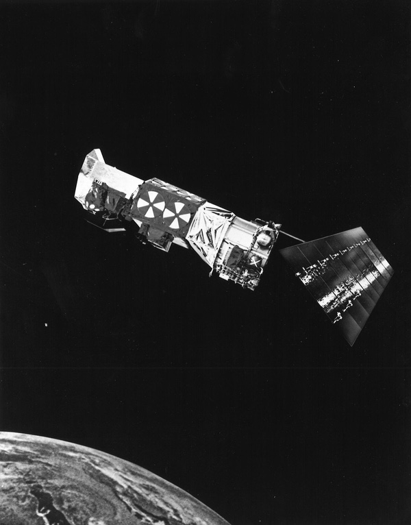
 Launch of a DMSP Block 5D-2 satellite in the 1980s. The 5D-2 was heavier than the 5D-1 and required the Atlas launch vehicle. Air Force hesitancy to switch launch vehicles during the late 1970s contributed to delays in the delivery of the 5D-2, which exacerbated a gap in coverage when the last Block 5D-1 was lost in a launch vehicle failure in 1989. (credit: Peter Hunter Collection) |
The biggest remaining outlier was launch operations, which were still conducted by Air Force personnel, unlike all other US Air Force launch operations that were handled by contractors. Although contractors also occasionally lost spacecraft, the embarrassing failure of the last Block 5D-1 satellite to reach orbit and the resulting gap in military weather satellite data led to the end of “blue suit” Air Force launches at Vandenberg.[62] Contractors would now launch the DMSPs, like they did all the other Air Force satellites. In 1982, the Air Force established a Space Command that took over responsibility for operating the Maine and Washington State ground stations as well as the DMSP Command and Control Center at Offutt Air Force Base.[63]
The problems that DMSP development suffered throughout the 1970s were investigated by several groups, including one led by now-Major General Jack Kulpa, who had run the program a decade and a half earlier. One of the primary problems the investigations identified was that DMSP had transitioned from a relatively simple system serving a single primary need (supporting satellite reconnaissance) to a complex system serving many users. However, program funding and personnel had not increased sufficiently to keep up with this new complexity and broader user community.[64]
As Major Michael D. Abel concluded in a history of the DMSP, the Air Force also felt pressured by the desire of some in the executive branch throughout the 1970s to converge the civil and military systems. This led them to keep the DMSP budget from growing, lest they lose control of the program.[65]
The military weather gap that started in summer 1980 lasted until December 1982, when the first Block 5D-2 satellite was launched, although that satellite did not become fully operational until early 1983, and a full constellation consisted of two satellites. The DMSP orbital constellation was not restored to full health until November 1983, when the seventh satellite was launched.[66]
 By the 1980s, the US Air Force operated two DMSP satellites in polar orbit. They could beam their data directly to fixed ground stations as well as mobile stations, including ships at sea. (credit: USAF) |
Conclusion
Despite the dark times experienced by the Air Force weather satellite program in the early 1980s, the early history of the Defense Meteorological Satellite Program was remarkable. Many technologies developed for DMSP ended up in the civilian weather program. They included the side-spinner design, the three-axis-stabilized Block 5D that served as the basis for later NOAA satellites, as well as instruments first flown on military satellites that migrated over to civilian use.
According to an official history, “DMSP significantly increased the image-search system effectiveness of NRO reconnaissance satellites and of Strategic Air Command SR-71 and U-2 reconnaissance aircraft, while it markedly reduced the number of aerial meteorological sorties.”[67]
Irony is common in Washington, but the weather satellite programs had more than their fair share: the NRO meteorological satellite program had been created as an “interim” solution until NOMSS was available. When NOMSS slipped, NRO’s Program 417 became a permanent solution. When NOMSS continued to slip, the civil TOS—based upon the Program 417 design—was created as an “interim” solution until a better one could be found. TOS also became permanent. Later the Block 5D design became the basis for NOAA’s Polar Orbiting Satellite System. Despite the military weather satellite program being established in the shadows of the civilian program, it ultimately proved vital to its later success.
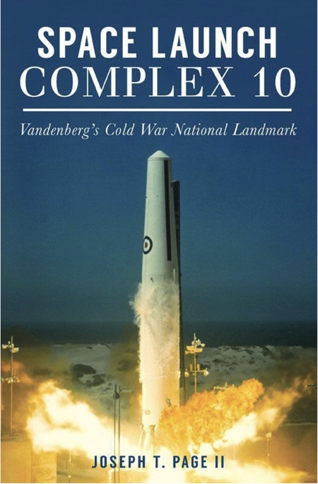 Most of the DMSP satellites launched during the 1960s and 1970s launched from Space Launch Complex 10 at Vandenberg Air Force Base. The complex has been preserved as a museum on the base. The role of Slick-10 launching these and other rockets is detailed in this book by Joseph T. Page II. |
Acknowledgement
The author acknowledges the pioneering work done by historian Cargill Hall in chronicling this program.
Program 417 launches
| Date | Launch Vehicle | Payload | Result | Notes |
|---|---|---|---|---|
| May 23, 1962 | Scout SLC-5 | Block I | Failure | Second stage exploded |
| August 23, 1962 | Scout SLC-5 | Block I | Success | |
| February 19, 1963 | Scout SLC-5 | Block I | Partial success | Improper orbit |
| April 26, 1963 | Scout SLC-5 | Block I | Failure | Third stage exploded |
| September 27, 1963 | Scout SLC-5 | Block I | Failure | Third stage failure |
| January 19, 1964 | Thor-Agena D SLC-1W | 2 Block I satellites | Success | |
| June 17, 1964 | Thor-Agena D SLC-1W | 2 Block I satellites | Success | |
| January 18, 1965 | Thor-Burner I SLC-10W | Block I | Failure | Payload shroud did not separate |
| March 18, 1965 | Thor-Burner I SLC-10W | Block I | Success | |
| May 20, 1965 | Thor-Burner I SLC-10W | Block III | Success | |
| September 9, 1965 | Thor-Burner I SLC-10W | Block II | Success | |
| July 1, 1966 | Thor-Burner I SLC-10W | Block II | Failure | Upper stage failed to ignite |
| March 30, 1966 | Thor-Burner I SLC-10W | Block II | Success |
Program 417 Block IV Launches
| Date | Launch Vehicle | Payload | Result | Notes |
|---|---|---|---|---|
| September 15, 1966 | Thor-Burner II SLC-10W | Block IVA | Success | |
| February 8, 1967 | Thor-Burner II SLC-10W | Block IVA | Success | |
| August 23, 1967 | Thor-Burner II SLC-10W | Block IVA | Success | |
| October 11, 1967 | Thor-Burner II SLC-10W | Block IVA | Success | |
| May 23, 1968 | Thor-Burner II SLC-10W | Block IVB | Success | |
| October 22, 1968 | Thor-Burner II SLC-10W | Block IVB | Success | |
| July 22, 1969 | Thor-Burner II SLC-10W | Block IVB | Success |
DMSP Block VA, VB, and VC Launches
| Date | Launch Vehicle | Payload | Result | Notes |
|---|---|---|---|---|
| February 11, 1970 | Thor-Burner II SLC-10W | Block VA | Success | |
| September 3, 1970 | Thor-Burner II SLC-10W | Block VA | Success | |
| February 17, 1971 | Thor-Burner II SLC-10W | Block VA | Success | |
| October 14, 1971 | Thor-Burner II SLC-10W | Block VB | Success | |
| March 24, 1972 | Thor-Burner II SLC-10W | Block VB | Success | |
| November 9, 1972 | Thor-Burner II SLC-10W | Block VB | Success | |
| August 17, 1973 | Thor-Burner II SLC-10W | Block VB | Success | |
| March 16, 1974 | Thor-Burner II SLC-10W | Block VB | Success | |
| August 9, 1974 | Thor-Burner II SLC-10W | Block VC | Success | |
| May 24, 1975 | Thor-Burner II SLC-10W | Block VC | Success | |
| February 19, 1976 | Thor-Burner II SLC-10W | Block VC | Failure | Failed to orbit due to propellant loading error. |
DMSP Block 5D-1 and Block 5D-2 Launches
| Date | Launch Vehicle | Payload | Result | Notes |
|---|---|---|---|---|
| September 11, 1976 | Thor-Burner II SLC-10W | Block 5D-1 | Success | Satellite tumbled upon reaching orbit, was recovered. |
| June 5, 1977 | Thor-Burner II SLC-10W | Block 5D-1 | Success | |
| May 1, 1978 | Thor-Burner II SLC-10W | Block 5D-1 | Success | |
| June 6, 1979 | Thor-Burner II SLC-10W | Block 5D-1 | Success | |
| July 15, 1980 | Thor-Burner II SLC-10W | Block 5D-1 | Failure | First and second stages did not fully separate. |
| December 21, 1982 | Atlas E SLC-3W | Block 5D-2 | Success | |
| November 18, 1983 | Atlas E SLC-3W | Block 5D-2 | Success | |
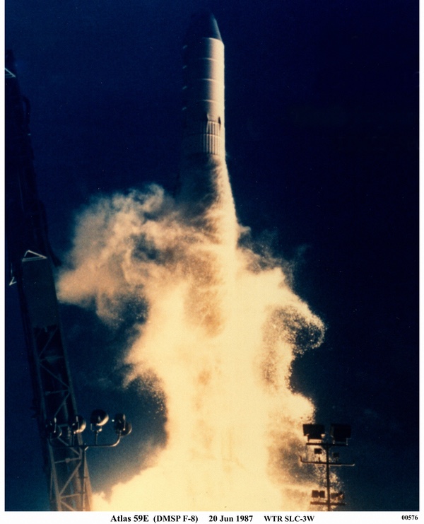
| June 20, 1987 | Atlas E SLC-3W | Block 5D-2 | Success | |
| February 3, 1988 | Atlas E SLC-3W | Block 5D-2 | Success | |
| December 1, 1990 | Atlas E SLC-3W | Block 5D-2 | Success | |
| November 28, 1991 | Atlas E SLC-3W | Block 5D-2 | Success | |
| August 29, 1994 | Atlas E SLC-3W | Block 5D-2 | Success | |
| March 24, 1995 | Atlas E SLC-3W | Block 5D-2 | Success | |
| April 4, 1997 | Titan II SLC-4W | Block 5D-2 | Success |
Endnotes
- R. Cargill Hall, “A History of the Military Polar Orbiting Meteorological Satellite Program,” National Reconnaissance Office, September 2001, pp. 1-10.
- Ibid., p. 15.
- Ibid.
- Ibid., p. 17.
- Ibid., pp. 11-12.
- Ibid., pp. 16-17.
- “The Defense Meteorological Satellite Program Sensors: An Historical Overview,” DMSP Program Office, Los Angeles, CA, May 1993, p. 5.
- Ibid., p. 6.
- Ibid., pp. 5-6.
- Ibid., p. 6.
- “Industry Observer,” Aviation Week and Space Technology, January 27, 1969.
- R. Cargill Hall, p. 18.
- Ibid.
- Ibid., p. 20.
- Ibid., pp. 18-19; Donald Boucher and Anthony Stier, “DMSP Instruments: A 50-Year Legacy,” Crosslink, Spring, 2010, pp. 64-69.
- “The Defense Meteorological Satellite Program Sensors: An Historical Overview,” p. 7.
- R. Cargill Hall, p. 20.
- Ibid.
- Ibid.
- Major Michael D. Abel, “History of the Defense Meteorological Support Program: Origin Through 1982,” Air Command and Staff College, Air University, Maxwell AFB, p. 58.
- R. Cargill Hall, p. 15.
- Major Michael D. Abel, p. 19.
- “The Defense Meteorological Satellite Program Sensors: An Historical Overview,” pp. 8-10.
- R. Cargill Hall, p. 21.
- Donald Boucher and Anthony Stier, pp. 64-69.
- “The Defense Meteorological Satellite Program Sensors: An Historical Overview,” p. 7.
- “New Weather Satellite Series Planned,” Aviation Week & Space Technology, July 15, 1974, p. 41.
- R. Cargill Hall, p. 22.
- Ibid.
- Donald Boucher and Anthony Stier, pp. 64-69.
- R. Cargill Hall, p. 24.
- Ibid., p. 25.
- Ibid., p. 26; Donald Boucher and Anthony Stier, pp. 64-69.
- Major Michael D. Abel, p. 37.
- Major Michael D. Abel, pp. 42-43.
- Ibid., p. 43.
- R. Cargill Hall, pp. 26-27.
- Ibid., p. 27.
- Major Michael D. Abel, p. 38.
- Ann Mazuk, John Haas, W. John Hussey, Leslie Belsma, and John Bohlson, “An Overview of Meteorological Satellites,” Crosslink, Winter, 2005, pp. 6-10; Steven R. Strom and George Iwanaga, “Overview and History of the Defense Meteorological Satellite Program.” Crosslink, Winter, 2005, pp. 11-15; Major Michael D. Abel, pp. 38-41.
- Major Michael D. Abel, p. 39.
- Ibid., pp. 39-40.
- Ibid., p. 40.
- Ibid,, p. 41.
- “The Defense Meteorological Satellite Program Sensors: An Historical Overview,” p. 10.
- R. Cargill Hall, pp. 22-23.
- “Defense Satellite Modifications Under Way,” Aviation Week & Space Technology, May 30, 1977, p. 16.
- R. Cargill Hall, p. 16.
- Major Michael D. Abel, p. 32.
- Janice Hill, Weather from Above – America’s Meteorological Satellites, Smithsonian Institution Press, 1991. See also: “Weather Satellites – User Views on the Consequences of Eliminating a Civilian Polar Orbiter,” GAO/RCED-86-111, March 1986; “Weather Satellites – Economies Available by Converging Government Meteorological Satellites,” GAO/NSIAD-87-107, April 1987; Thomas J. Schulz, Associate Director, Systems Development and Production Issues, to The Honorable C.W. Bill Young, Chairman, Subcommittee on Appropriations, House of Representatives, “Meteorological Satellites,” GAO/NSIAD-95-87R, February 6, 1995; Major Michael D. Abel, p. 31.
- Ibid., p. 33.
- Ibid., p. 33.
- Ibid., pp. 34-35.
- Ibid., p. 35.
- Ibid., p. 36.
- U.S. Department of Commerce, National Oceanic and Atmospheric Administration, “Envirosat -2000 Report: Comparison of the Defense Meteorological Satellite Program (DMSP) and the NOAA Polar-orbiting Operational Environmental Satellite (POES) Program,” October 1985, p. II-2.
- “News Digest,” Aviation Week & Space Technology, July 21, 1980; Strategic Air Command, “Operation 7383, Block 5D-1/S-4, Flight 5, 14 July 1980.”
- Major Michael D. Abel, p. 42.
- “USAF Network Down to One Weather Satellite,” Aviation Week & Space Technology, September 29, 1980, p. 66.
- Major Michael D. Abel, p. 42.
- R. Cargill Hall, p. 30.
- For more on the Air Force’s “blue suit” space launch capability, see Joseph T. Page II, Space Launch Complex 10 – Vandenberg’s Cold War National Landmark, The History Press, Charleston, SC, 2016.
- R. Cargill Hall, p. 33.
- Major Michael D. Abel, p. 48.
- Ibid., p. 49.
- Ibid., p. 45.
- R. Cargill Hall, p. 34.
Note: we are using a new commenting system, which may require you to create a new account.