The origins and evolution of the Defense Support Program (part 1)Infrared for missile warningby Dwayne A. Day
|
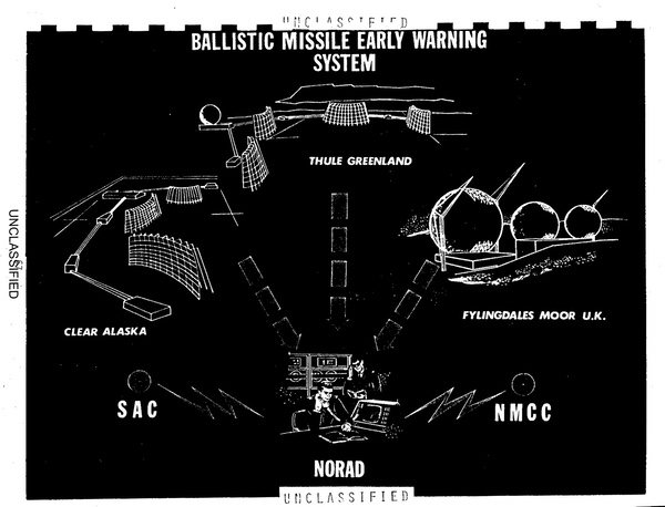 Late 1960s illustration of the Ballistic Missile Early Warning System (BMEWS) which relied upon a series of radars to feed information on Soviet missile launches to Strategic Air Command (SAC), North American Air Defense Command (NORAD), and the National Military Command Center (NMCC). The infrared Defense Support Program satellites provided an additional method to detect and track ballistic missiles. (credit: USAF) |
The origins of DSP
Early warning of potential attack on the United States was one of the primary concerns of the fledgling American military space program. Early efforts concentrated on low orbit shortwave infrared satellites under the name Midas, for Missile Defense Alarm System. Midas evolved into Program 461 and test flights were conducted from 1963 to 1966.
| The ultimate nightmare for US generals was that a Soviet FOBS could be launched over the South Pole and strike the United States totally undetected, destroying command and control centers before a response could be made. But even a FOBS launched to the east or west could present a major problem, since it might go undetected by radar until as little as five minutes from impact. |
But although the latter tests of Program 461 satellites were successful, there were still questions as to the cost-effectiveness of satellites versus ground-based radars for the early warning mission. Space-based systems offered two advantages. The first was the ability to increase warning time of a Soviet attack. The Ballistic Missile Early Warning System (BMEWS), consisting of radars located at Clear, Alaska; Thule, Greenland; and Fylingdales, Great Britain, could provide approximately 15 minutes warning time of a ballistic missile attack on the United States. They were backed up by a series of coastal radars intended to warn of submarine-launched ballistic missile (SLBM) attack. A satellite-based system could increase the ICBM warning time from 15 to as much as 27 minutes, as well as double the warning time for many SLBM launches.
The second advantage of a space-based system was warning against Soviet Fractional Orbital Bombardment System (FOBS) attacks. FOBS meant that the warhead was placed in a partial orbit which increased its range. This delivery method also allowed the warhead to reenter at a low altitude, which meant that a missile could be launched from the Soviet Union in any direction and reenter below air defense radars. The ultimate nightmare for US generals was that a Soviet FOBS could be launched over the South Pole and strike the United States totally undetected, destroying command and control centers before a response could be made. But even a FOBS launched to the east or west could present a major problem, since it might go undetected by radar until as little as five minutes from impact. Satellite systems presented the best way of detecting FOBS launches. In addition, satellites using infrared detection offered a countercheck to the radar detection systems, thus increasing confidence against both surprise attack and false alarms.
Despite these advantages, space-based early warning promised to be expensive. Program 461 satellites were all tested in low Earth orbit. The biggest drawback to this orbit was the number of satellites needed to provide adequate coverage of the Soviet Union. Some estimates, based upon a low Earth orbit constellation, required as many as 20 or more satellites. A constellation using highly inclined, highly-elliptical orbits could require nine or ten satellites. The Soviet Union chose the multiple satellites in elliptical orbit approach because the country’s northern location made it more difficult to operate satellites in geosynchronous orbit.
A geosynchronous missile warning constellation could provide coverage with as few as two satellites—one in each hemisphere. Admittedly, a geosynchronous satellite would pose some challenges compared to low orbiting satellites, one of the biggest being the required sensitivity of the infrared sensor. In 1965, the Air Force evaluated the options for early warning from space and chose a geosynchronous-based system as both technically and economically feasible.
Program 266 is Started
In November 1965, the Air Force ordered the Space Systems Division of the Space and Missiles Systems Organization (SAMSO) to redesignate a portion of Program 461 as Space Systems Program 266. Program 266 was to be a technology demonstration for the evolution of space early warning systems for the 70s and would be focused upon geosynchronous satellites.[2]
In early 1966, the Air Force redefined the Program 266 objectives to include Missile Strike Warning or MSR. MSR meant the capability of determining the ground-zero point of a nuclear explosion on enemy territory to a high degree of accuracy. These objectives were redefined shortly thereafter to include as a “very high priority” global early warning, MSR, attack assessment (known as AA, this was the ability to detect enemy nuclear detonations on US territory), and, apparently, tactical ballistic missile warning. A “high priority” was tactical meteorology and test ban monitoring, whereas intelligence test ban monitoring and navigation were considered “moderate priority” objectives. Communications capabilities were low priority. Sometime thereafter, the detection of tactical ballistic missiles was apparently eliminated, since these cooler targets were deemed too difficult to detect. “MSR” fell into disuse, being subsumed into the AA definition.
| With visions in their heads of a ten-megaton bomb with the Pentagon’s name on it sailing over Texas with three minutes’ warning before it hit Washington, Air Force headquarters ordered the Program 949 office to investigate the possibility of accelerating the early warning satellite effort so the first satellite would fly in 1969. |
The use of the higher orbit as well as the increased demands placed on the vehicle (and higher weight) dictated the use of a rocket more powerful than the Atlas-Agena that had launched the earlier Program 461 satellites. Fortunately, the first launch of a Titan IIIA rocket was conducted from Cape Canaveral on September 1, 1964. This was followed by the first launch of a Titan IIIC rocket, with two strap-on solid boosters, on June 18, 1965. This launch placed a 9,525-kilogram dummy payload into low orbit. The Titan IIIC was designated as the launch vehicle for Program 266 satellites.
In response to an Air Force request, three proposals were submitted by two contractor teams, Martin/Raytheon and Aerojet-General/TRW, and one solo contractor, Lockheed Missiles and Space Company. In November 1966, the project was redesignated Program 949 and shortly thereafter the Air Force narrowed the competition to Lockheed and the Aerojet-General/TRW team. Space Systems Division forwarded the proposals to Systems Command and Air Force headquarters for a final decision. The Aerojet/TRW team was selected and contract negotiations began soon thereafter. The contract was to be for an estimated target of $105 million for a three-satellite buy: two operational satellites and one spare. The satellites were to weigh approximately 907 kilograms and have an average lifetime of 19 months (15 months was considered adequate for the research and development satellites).[3]
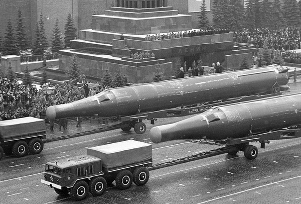 The R-36 missile, designated the SS-9 by the US intelligence community, was the basis of the Soviet Fractional Orbital Bombardment System (FOBS) that could send a large nuclear warhead over the South Pole to attack the United States from a direction that was not covered by radar warning systems. The DSP satellites were developed in part to detect this threat. (credit: GlobalSecurity.org) |
Fractional Orbital Bombardment System (FOBS)
During the 1965 May Day parade through Red Square, the Soviet commentator had touted the virtues of the SS-10 Scrag ICBMs, which he called “orbital missiles” with limitless range and an ability to hit targets from virtually any direction. The SS-10 never saw service in this role.[4]
A little over a year later, in September and November of 1966, and again in January of 1967, the Soviets conducted launches of a new rocket which the US Air Force designated SS-X-6. This rocket was essentially an SS-9 Scarp ICBM booster (known as the R-36 in the Soviet Union) with a new third stage and reentry vehicle (the new rocket was apparently initially given the designation SL-11, or F-1-r by the US intelligence community, which classified it as a space booster, but it was later labeled SS-9 Mod 3).[5] All three tests placed the second and third stages, as well as the reentry vehicle, into low Earth orbit. The two latter tests were failures, but the first test involved the deorbiting of the reentry vehicle. This was the first Soviet development test of a FOBS. All three tests were detailed in a Top Secret CIA National Intelligence Estimate on the Soviet Space Program in March 1967.[6] During a later Soviet FOBS test, the United States got extremely lucky when one of its signals intelligence satellites was overhead during vehicle reentry and gathered extensive telemetry signals all the way to impact. This, combined with telemetry intercepts from the ground during the missile’s initial flight, provided the United States with a wealth of data on FOBS.[7]
Intelligence officers and military leaders in the United States were clearly worried. The SS-9 was rumored to carry a truly massive 25-megaton warhead. Its second stage fired to deorbit the reentry vehicle only three minutes from impact. The FOBS version sacrificed 30% of its throw-weight in order to fly its unique trajectory, meaning that it could only carry a ten-megaton bomb, which was still big enough to smash any American command and control center.
With visions in their heads of a ten-megaton bomb with the Pentagon’s name on it sailing over Texas with three minutes’ warning before it hit Washington, Air Force headquarters ordered the Program 949 office to investigate the possibility of accelerating the early warning satellite effort so the first satellite would fly in 1969. Secretary of Defense Melvin Laird publicly announced three unnamed responses to this new threat. One was obviously the development of the Safeguard anti-missile system (later canceled). Another was probably the continued development of MIRVed ICBMs.[8] The third was early warning satellites. But by November, apparently convinced that there were no urgent threats from FOBS, Air Force headquarters reversed course and directed that the program office maintain the original schedule of preparing three development satellites for launches in June, September, and December 1970.[9] Soon the emergence of a new threat, the SS-N-6 Serb submarine launched ballistic missile, first tested in 1967, provided further impetus for maintaining this schedule.
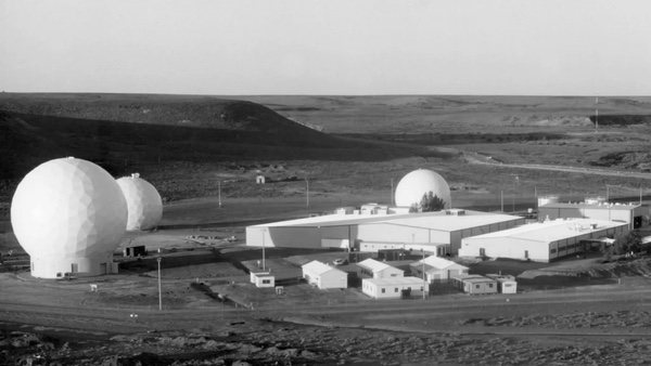 The Joint Defense Facility Nurrungar, located near the remote small town of Woomera, Australia, was the overseas ground station for Defense Support Program satellites. Construction started in late 1969/early 1970. Although the fact that a joint Australian-American military site was being built was public, its mission was classified, in part to prevent protests in Australia. (credit: Australian Defense Force) |
While development and construction of the satellites was proceeding, the Air Force and Department of Defense determined that an eastern hemisphere ground station would be needed to receive data from the eastern satellite, which observed Soviet and Chinese missile fields. The ground station was where the data would be reduced and transmitted to the United States via undersea cable or communications satellite. The program office identified Australia as the site of such a station, which had already been selected as the site for another ground station for US electronic intelligence satellites. Negotiations were begun to establish a ground site called Nurrungar near the small town of Woomera. It was designated as the Overseas Ground Station (OGS). In 1969, Aerospace Defense Command recommended that Waverly Air Force Station, Iowa, be considered as the US ground station, but this was rejected. Another site in the United States, Buckley Air National Guard Base near Denver, Colorado, was selected for the western satellite and designated the Continental Ground Station (CGS). The 2nd Space Warning Squadron was activated at Buckley on July 1, 1971.[10] The locations of both ground stations for the missile warning satellite program were classified, primarily due to the desire by both governments not to have them become the focus of anti-nuclear protests. In addition, a training and software test facility was set up at Lowry Air Force Base in Denver.
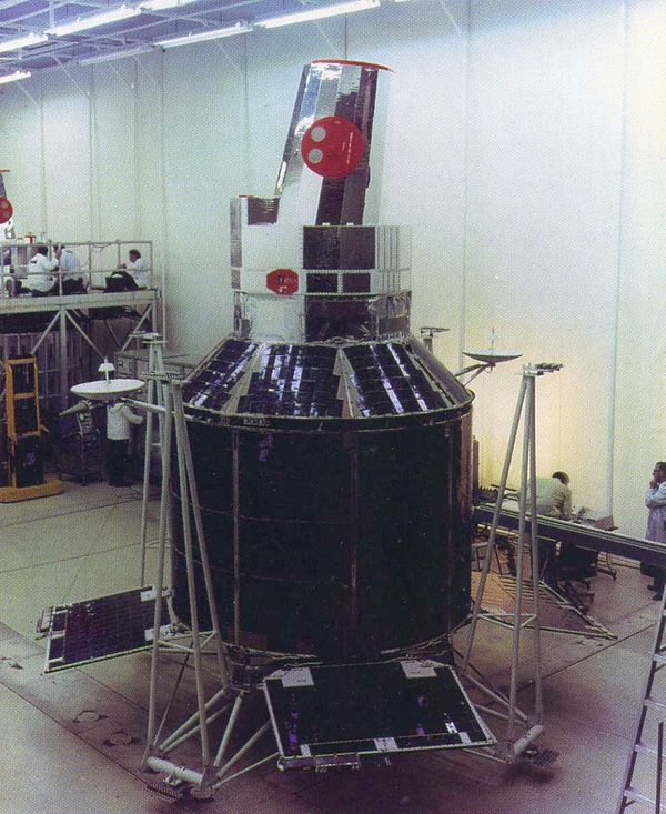
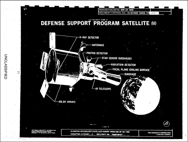 A 1969 illustration of a Defense Support Program satellite. The spinning satellites operated in geosynchronous orbits, allowing them to view much of the Earth's surface. (credit: USAF) |
The Defense Support Program
Nuclear detection from space, then provided by the VELA series of satellites, was to be incorporated into Program 949 through the use of a Visible Light Surveillance System (VSS) for detecting the flash of a nuclear burst and indicating its location. International Telephone and Telegraph designed the sensor hardware and Aerojet was responsible for the electronics. But by December 1967 it became obvious that VSS was not going to meet specifications. Its sophisticated electro-optical sensor tended to “smear” point targets, making it difficult to determine their location.[11]
| By analyzing the temperature, location, and trajectory of a hot infrared source, the satellite could build up both a description of the type of missile as well as its target. |
In June 1969, due to a security breach, the project underwent yet another name change, this time from Program 949 to Program 647. It was also finally given an unclassified, deliberately obscure cover name: Defense Support Program, or DSP. No satellites were ever launched under the designations of Program 266 or 949, although some publications in the 1970s and 1980s claimed that satellites with these designations were launched into orbit.
By September of 1969 the Air Force was forced to terminate ITT’s development contract for the nuclear detection sensor. It turned to the Atomic Energy Commission’s Sandia Laboratories for a solution. RADEC-1, for RAdiation DEtection Capability, was proposed to perform all the requirements of the canceled system by detecting X-ray emissions from nuclear explosions.[12] It would fulfill both the MSR and AA roles, allowing generals to determine which targets they had successfully hit as well as what their own damages were. The employment of these sensors meant that, despite its classification as an early warning satellite, DSP was also intimately involved in nuclear warfighting plans.
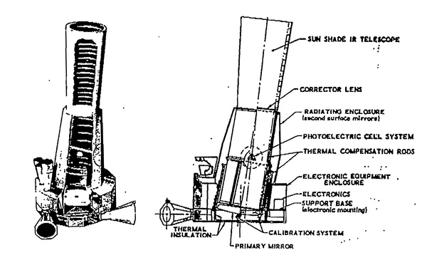 The primary sensor on the DSP satellites was an infrared telescope set at an angle on the spinning satellite bus. This enabled it to sweep across the face of of the Earth, scanning for the hot exhaust of missiles and rockets. |
The satellite built by TRW was 7.01 meters long and 3.05 meters in diameter. It had a 3.66-meter-long Schmidt infrared telescope with a linear array of 2,048 lead sulphide detectors with a peak spectral response of 2.7 microns. It had an 18-month design life and weighed 898 kilograms with a sensor package weighing 321 kilograms. It had four extendable solar panels on “paddles” mounted to the rear. Total power was 400 watts. The satellite was designed to rotate six times per minute. The telescope was set slightly off-angle to the rest of the satellite by 7.5 degrees. Thus, as the satellite rotated, the sensor “scanned” the entire face of the Earth, sweeping it like the face of a clock, returning to any given point six times each minute. The sensor provided below-the-horizon coverage by spotting the missile’s plume against the background of the Earth. By analyzing the temperature, location, and trajectory of a hot infrared source, the satellite could build up both a description of the type of missile as well as its target.
The first flight-qualified spacecraft started a full inspection in May 1970, shortly after the first RADEC was delivered to Aerojet. By October the inspection was completed, minor problems corrected, and the spacecraft shipped to the Cape Canaveral launch site for a scheduled launch on November 3 atop Titan IIIC-19. Following installation of the payload fairing, inspectors discovered that the satellite was contaminated with metal filings produced during the fairing manufacture and shaken loose during installation. The satellite was cleaned without disruption to the schedule and readied for launch almost four years to the date after the contract had been awarded.
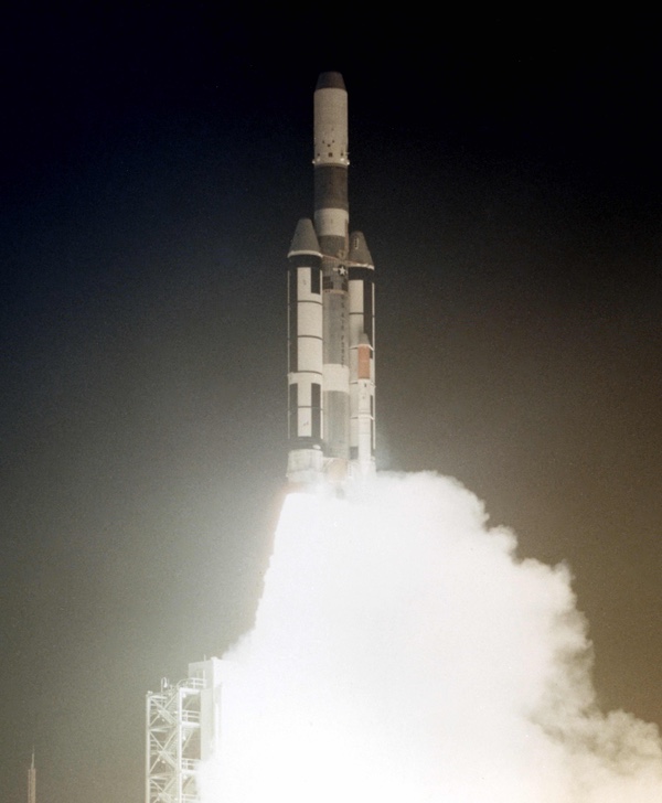 Launch of the first Defense Support Program missile warning satellite on November 6, 1970, from Florida. At least one Defense Support Program satellite may remain in limited use today. |
Initial operations
On November 6, 1970, a Titan IIIC rocket carrying the first Defense Support Program satellite lifted off its launch pad in Florida. The rocket initially performed as planned but suffered an anomaly later in the flight when its Transtage upper stage misperformed. This resulted in the satellite, known as Flight 1 or F-1, being placed into an orbit of 26,050 by 35,886 kilometers. Although this was not the planned geosynchronous orbit and prevented the satellite from achieving full status as an operational early warning system, it did allow for extensive testing of the satellite’s capabilities using a variety of US missile launches as observation targets. The first launch of DSP enabled the Air Force to check out the operation of the satellite and assess its performance, although it did not enter operational service, capable of providing reliable warning of Soviet missile launches.[13]
The second satellite was scheduled for launch on May 4, 1971, but a countdown problem forced a delay and it didn’t lift off until May 6 aboard Titan IIIC-20. This time the booster performed normally, and after the Transtage burned out and separated, the spacecraft slowly came to life. The satellite was named Flight-2 or F-2. By May 23, 1971, it was turned over to the newly built ground station at Nurrungar in Australia. The satellite’s initial location was 65° E, over the Indian Ocean, where it could monitor Soviet and Chinese ballistic missile fields. It sent its data down to Nurrungar in Australia.[14]
 The first DSP satellite was launched in 1970. It did not reach its intended orbit, limiting its ability to serve as an operational missile warning satellite. However, its sensor and other systems were still tested in orbit, proving the ability of the system to detect various types of missile launches. |
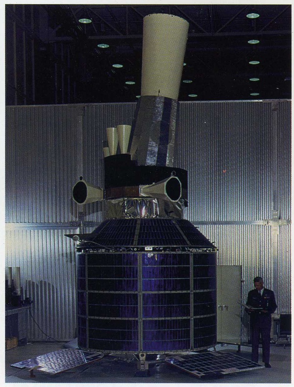
The third satellite was launched on March 1, 1972, atop Titan IIIC-22 and named F-3. It became the first western hemisphere satellite and was stationed initially at 80° W over Ecuador, sending its data down to the ground station in Colorado.
Shortly after going into operation the Link III converter failed, causing a loss of redundancy on reception of commands from the ground. In addition, the satellite suffered from a slight degradation in star sensor performance and occasional noise bursts in data transmission. But neither problem was major, and the Air Force now had an operational missile warning satellite system in orbit.
 The second DSP satellite was launched in May 1971 and became the first operational missile warning satellite for the United States. The early spacecraft exceeded their planned design lifetimes, resulting in space satellites accumulating at the manufacturer. |
The DSP operational constellation and Phase II
The initial plan had been to operate two satellites in geosynchronous orbit. But by 1972, the Air Force had decided that the threat from Soviet SLBMs launched from the western Pacific justified expanding the DSP constellation to three operational satellites.
| The Air Force planned on replacing the DSP satellites in orbit based upon their predicted lifetimes. But the existing satellites would exceed their design lifetimes by a considerable margin, enabling the Air Force to change its launch plans. |
Satellite F-4, the last of the Phase I satellites, was successfully launched on June 12, 1973, atop Titan IIIC-24. F-4 was actually the first satellite to be completed and had served as the qualification satellite, undergoing an extensive series of tests of its systems before being overhauled and prepared as a flight-qualified spacecraft. Flight 4 was the first satellite to take up position over the Pacific Ocean, apparently at 105° W.
Satellites F-2 and F-3 initially occupied stations at 65° E and 80° W respectively. From its location, satellite F-3 provided coverage over most of the Atlantic Ocean and the eastern Pacific. Satellite F-2 covered the Soviet and Chinese missile fields and the eastern Atlantic Ocean. But until a third operational satellite could be placed in orbit, the western Pacific was uncovered. Soviet submarine launched ballistic missiles had increasing ranges, which would allow them to be launched from the western Pacific undetected by DSP. Once F-4 achieved orbit, this gap in coverage could be closed.
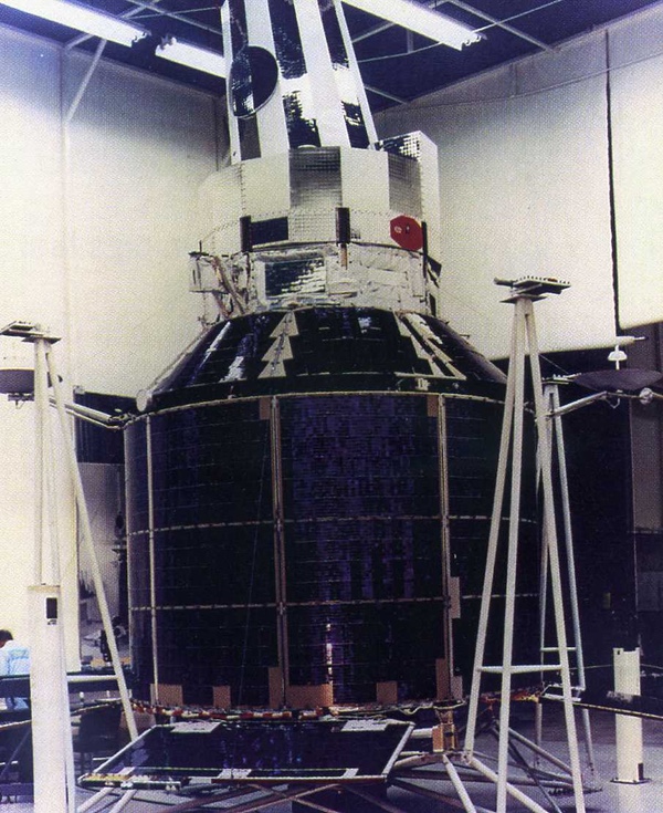
 The third DSP satellite completed at TRW's facility in California. The satellite is only missing its sun shade at the end of the telescope. This satellite was launched in March 1972. The original plan had been for the DSP constellation to consist of two satellites, one looking at the main Soviet ICBM fields in the USSR, and the other covering the Atlantic Ocean and eastern Pacific Ocean looking for submarine-launched ballistic missiles (SLBMs). However, the development of longer-range Soviet SLBMs that could be launched from the western Pacific resulted in the U.S. Air Force expanding the constellation to three spacecraft. |
With three operational satellites in orbit, the Air Force could now adjust their positions to expand global missile warning coverage. Satellite F-3 thus moved from 80° W to 70° W, covering the entire Atlantic Ocean as well as much of the eastern Pacific bordering the United States. This station was named DSP-West Atlantic or DSP-W (LANT). Satellite F-2, freed of the burden of monitoring the eastern Atlantic Ocean, was then apparently moved from 65° E to 69° E, where it covered the entire Soviet and Chinese missile fields, as well as the Indian Ocean. This position was labeled DSP-East or DSP-E. (Although the operational stations of DSP satellites were classified for much of their service, their locations were regularly reported in NORAD’s two-line orbital element sets until 1982. Element sets for the 1970s are difficult to acquire and therefore data on the early positions is spotty.) The new satellite, F-4, took up position at 105° W and this position was named DSP-West Pacific, or DSP-W (PAC).
In the first half of 1971 the program office began contract negotiation with TRW on the Phase II satellites. By June 30, initial hardware production was started on the first of four Phase II satellites. The satellites were not to be significantly different from their predecessors. Primary improvements included an increase in reliability and minor improvements in various systems, particularly the main sensor, which would have the capability of scanning the entire field of view. These changes resulted in an increase in weight from approximately 907 kilograms for the Phase I satellites to approximately 1,043 kilograms. The reaction wheel speed was increased from 3,600 to 4,100 rpm because of this extra weight. Power was increased from 400 to 480 watts. More importantly, satellite lifetime was to be doubled to three years. The Air Force planned on replacing the DSP satellites in orbit based upon their predicted lifetimes. But the existing satellites would exceed their design lifetimes by a considerable margin, enabling the Air Force to change its launch plans.
Next: DSP evolves.
References
- For a detailed history of the development of missile warning satellites, see: Jeffrey T. Richelson, America’s Space Sentinels: DSP Satellites and National Security (2nd edition), University Press of Kansas, 2012.
- History of The Space Systems Division, Space and Missile Systems Organization, 1 January-30 June 1967, History Office, SAMSO, Air Force Systems Command, November 1969, p. 101. Contained in NASA History Division, Reference Collection files: “Air Force Satellites: DSP.”
- Ibid., p. 102; History of The Space Systems Division, Space and Missile Systems Organization, July-December 1966, Robert E. McClellan and Harry C. Jordan, History Office, SAMSO, Air Force Systems Command, September 1968, p. 104. Contained in NASA History Division, Reference Collection files: “Air Force Satellites: DSP.”
- David Baker, The Shape of Wars to Come, Patrick Stephens, Cambridge, 1981, p. 105.
- “Soviet ICBM Activity during 1966,” Office of the Director of Intelligence, Headquarters, United States European Command, EUCOM Intelligence Report,” Wednesday, January 25, 1967, pp. 198-199. Contained in National Security Archive Collection.
- “The Soviet Space Program” National Intelligence Estimate Number 11-1-67, March 2, 1967
- For more info on FOBS see: Asif A. Siddiqi, “The Soviet Fractional Orbital Bombardment System (FOBS) – A Short Technical History,” Quest, Vol. 7, No. 4, Spring 2000, pp. 22-32.
- Kenneth Gatland, Missiles and Rockets, Macmillan Publishing Co., 1975, p. 146.
- History of Space and Missile Systems Organization, 1 July 1967-30 June 1969, Robert F. Piper, SAMSO History Office, March 1970, p. 214. Contained in NASA History Division, Reference Collection files: “Air Force Satellites: DSP.”
- United States Air Force Fact Sheet “2nd Space Warning Squadron, Buckley Air National Guard Base, Colorado,” September 1993. Also: Philip J. Klass, “U.S. Seeking Better Command Control Survivability,” Aviation Week & Space Technology, June 23, 1980, p. 54.
- History of Space and Missile Systems Organization, 1 July 1967-30 June 1969, Robert F. Piper, SAMSO History Office, March 1970, p. 232. Contained in NASA History Division, Reference Collection files: “Air Force Satellites: DSP.”
- History of Space and Missile Systems Organization, 1 July 1969-30 June 1970, Robert F. Piper, SAMSO History Office, pp. 61-63. Contained in NASA History Division, Reference Collection files: “Air Force Satellites: DSP.”
- History of Space and Missile Systems Organization, 1 July 1971-30 June 1972, Robert F. Piper p. 54. Contained in NASA History Division, Reference Collection files: “Air Force Satellites: DSP.”
- Col. J. Kidd and 1Lt. H. Caldwell, “Defense Support Program: Support to a Changing World,” paper presented at American Institute for Aeronautics and Astronautics Space Programs and Technologies Conference, March 24-27, 1992, AIAA 92-1518.
Note: we are using a new commenting system, which may require you to create a new account.