Another technique to identify “unknown” satellitesby Charles Phillips
|
| One thing that Space Track has neglected is to apply common sense to is which satellites will not have their orbital parameters available. |
The (default world official) satellite catalog is maintained by the US Space Force. They assign numbers to each known satellite and they assign the “COSPAR” designator (see below for a little more about that), which is one way that the international community labels satellites. They normally do an adequate job; the satellite catalog is at Space Track and many organizations and people use it.
One of their roles is to make orbital parameters for most satellites available, which organizations use for many purposes such as to communicate with their satellites. There are also “unknown satellites” available. There are other catalogs as well, most of which do not show unknowns. For many reasons, it would be handy to have a way to associate even some of the unknown satellites with which launch they flew into space on.
One thing that Space Track has neglected is to apply common sense to is which satellites will not have their orbital parameters available, something I have written about this before (see “Time for common sense with the satellite catalog”, The Space Review, April 10, 2017). As I have said before, the rules are inconsistently applied and that helps us in this case.
There are catalogs and there is also a list of satellites that are observed by the Visual Satellite Observer’s group. This is just a list and cannot qualify as a satellite catalog but it does have a lot of very unique information. I have been copying this list for a few years and the list can be used to do some very interesting analyses. These observers track many satellites whose parameters do not appear in Space Track. They associate many satellites with cataloged satellites and they appear to have done a good job with that. They also have “unknown” satellites and those can be very interesting; since there are few observers, though, they often have limited data on many satellites.
I have been developing a technique that seems to be useful to associate unknown satellites with known satellites and this technique may be very useful in situations where there is limited data. This is the second article about this technique; the first was applying it to a different type of satellites and orbits (see “A possible technique for giving names to nameless satellites”, The Space Review, October 28, 2019). This article will describe the results of applying this technique, called the RAAN Test, to some of the satellites which fly in various series of satellites.
We don’t have the space to talk about orbits or how to describe them, but the earlier article that is referenced above does have an explanation. (Endnote 1 is a page in a classic text that describes the orbital parameters.) But to start with, there is an angle called Right Ascension of Ascending Node (RAAN) that is measured in the plane of the Earth’s Equator that shows us where the orbit is located with respect to the ground below. This angle changes over time for various reasons and that change is referred to as precession. Endnote 2 is a description in a classic text that describes this phenomenon.
This technique may be useful in several efforts. Lately I have been looking at a class of satellites that locate radio emitters, such as those on ships, by using interferometry. The satellites measure the time difference of arrival of the signals. These are excellent examples of satellites that come in a series, with similar satellites launched into similar orbits.
| I have been developing a technique that seems to be useful to associate unknown satellites with known satellites and this technique may be very useful in situations where there is limited data. |
The original mission like these was the US Navy’s Naval Ocean Surveillance System or NOSS, also called White Cloud or Parcae. These have always been launched into a medium high orbit. They use an inclination of 56 degrees, and their orbital parameters are not available on Space Track. A civilian version of that appears to be the HawkEye 360 “Hawk” satellites. The Hawk satellites are not military so their orbital parameters are available on Space Track. They have mostly been put in a high inclination orbit but the “Hawk 6” set was put into an orbit with an inclination of 40.5 degrees.
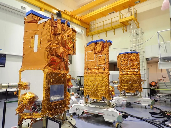
The French have apparently flown three versions of this type: the Essaim, then the ELISA satellites, and then the CERES satellites. Of course the Chinese have their version, the Shi Jian 6 series. Oddly, the Soviets/Russians have not apparently flown an interferometry satellite series. Let’s take a look at the French satellites.
One interesting mission was the 105th launch that happened in 2021, so it is referred to as COSPAR 2021-105. On this launch, four objects were put into space: three payloads (CERES 1–3) and an upper stage (called AVUM R/B in the satellite catalog). In the satellite catalog, only the upper stage has its orbital parameters available. But the Visual Satellite Observer’s list has orbital parameters for the three payloads. With their high inclination (97 degrees) and sort of high altitude (approximately 630 x 635 kilometers) they were likely a version of the NOSS.
Launch 2011-076 is ELISA and they are named for the two orbital planes that they are in. The electronic intelligence satellites were apparently satellite number 38007, called ELISA W11; satellite 38008, ELISA E24; satellite 38009, ELISA W23; and the last satellite 38010, ELISA E12. Here E refers to East and W refers to West. There are no orbital parameters for them in Space Track but there were other payloads on that launch: SSOT (satellite 38011), Pleiades 1 (satellite 38012), and ASAP-5 (satellite 38013), and those parameters are available. The orbit is the same as the CERES satellites.
On launch 2004-049, the first payload (Helios 2A), the second payload (Nanosat1), and the seventh payload (Parasol), as well as the upper stage have their orbital parameters available. There are four Essaim satellites that were apparently the first operational electronic intelligence mission, likely a test series, which have had their parameters withheld. These satellites apparently were turned off in October of 2010 and they were replaced with the ELISA satellites in very similar orbits. The Helios payload apparently experienced a breakup while the orbital parameters were withheld and it lowered its altitude. Then (presumably) the French decided to make the orbital parameters available. Due to the desire to keep this article a little shorter and less technical I have not included Helios 2A in this discussion.
Since these Essaim satellites have been retired for years, you might ask yourself why their orbital parameters are still withheld—and there is almost certainly no good answer. Probably the risk-averse nature of the US military means that no one wants to declassify them since they just seldom look at which satellite’s parameters are withheld. On most US national security launches, none of the objects from the launch are normally available, even small satellites like cubesats. But on these launches, only the payload’s parameters are withheld. There isn’t a lot of consistency in how the rule is applied.
For the satellites that we are interested in, let’s get orbital elements at various times, referred to as the Epoch time. The elements are updated when new observations of the satellites are received. We can plot the RAAN for each epoch time and see how that angle changes.
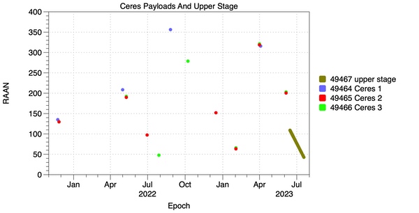 |
With this first plot we see the most current satellites, which are likely still operational. Since the RAAN gets smaller with passing time, the orbits are precessing east-to-west. We can see that the payloads have nearly identical precession rates; the upper stage that put them into orbit has a very similar precession rate. You can see that the upper stage’s orbital parameters are not withheld so orbital parameters are updated far more often (and so there are many more points) than the payload’s (by the amateur tracking network) are.
Now the angle RAAN has a range of 0 to 360, so when the angle exceeds either extreme it recycles back to the other extreme value.
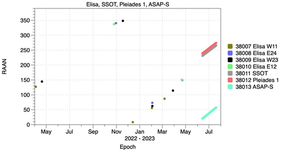 |
For the next oldest series, we can see that three objects’ parameters are not withheld and so for them there are many more available points to plot. The precession here is from west-to-east, so the value of RAAN increases over time. The precession rate for the other payloads is very similar to the rate for the Elisa payloads. Those are split between two planes: the East plane (the payloads have E in their name) and West plane (see the W in their names). If you look carefully at the plotted points between February and May of 2023 you can see that there are two planes.
Let’s “zoom in” on the points from November 2022 to May 2023 and eliminate the distracting points from SSOT, Pleiades 1, and ASAP-S so that we can see what the Elisa payloads look like.
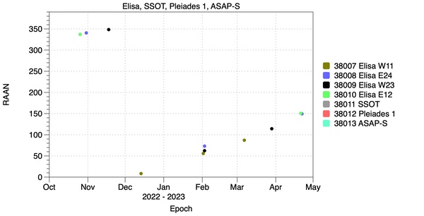 |
Again we don’t have many data points but I contend that points for Elisa W11 and Elisa W23 form a line and also Elisa E24 and Elisa E12 form a parallel line. It appears that there are indeed four objects.
Now let’s move to the oldest series, where the satellites have been turned off and the orbits have been permitted to vary without control.
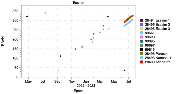 |
This is a more difficult plot to read. Here the unclassified objects show us what is going on and we can interpolate to see what the withheld objects are doing. The Observer group has seldom (at least lately) tracked the presumed Essaim satellites but they are tracking some unknown 9xxxx satellites. Here if you draw lines to connect the dots (for instance the three green ones) you will see that we are looking for three objects but apparently the Observers are tracking five. The latest parameters for the Essaim satellites are back in 2021 but they do lie along lines that indicate that they could be the same objects as are being tracked as 9xxxx objects today.
So my contention is that this test can be used to identify unknown tracks and to distinguish objects from each other. This test needs to have an analytical version and I am working on that. With these examples the RAAN Test almost seems like a solution in search of a problem, but this article does show another way to apply it that seems to give us valuable information. Further articles will expand on the technique and give more detailed examples.
The RAAN Test is inspired (see below) by another program that orbital analysts used when I was one, FLINT (see below). But RAAN Test is usable over many months whereas FLINT is usable only over a period of days.
Acknowledgement
This article could not have been written without help from two colleagues. Mike Marston wrote the critical pieces of software that were used to sort and group satellites. He is far better at writing C code than I am. The plots were produced with a very well designed application, DataGraph. Pamela Schultz, PhD there has been very helpful. Most people make plots using another application but DataGraph is far faster and more intuitive. I would also like to acknowledge Gunter Krebs, who maintains Gunter’s Space Page, which has an incredible amount of information and allowed me to check many details for this article.
The idea behind plotting these points owes a lot to a program that was available on the 427M computer system that Air Force orbital analysts used years ago. When we transitioned from the printer-only 496L to the very early graphics of the 427M we got a program called FLINT that allowed us to plot the time residuals (differences between predicted and actual time of observation) for satellites. It was written to help catalog objects from foreign launches (that is what FL stood for, I forgot what the INT stood for). But again, RAAN Test is usable over a period of months or years whereas FLINT is usable over days at most.
Endnotes
- Bate, Mueller, and White, Fundamentals Of Astrodynamics, Dover Publications, 1971. Page 58.
- Bate, Mueller, and White, Fundamentals Of Astrodynamics, Dover Publications, 1971. Page 156.
Note: we are using a new commenting system, which may require you to create a new account.
