The threat from China and Russia’s space-based SIGINT satellitesby Matthew Mowthorpe
|
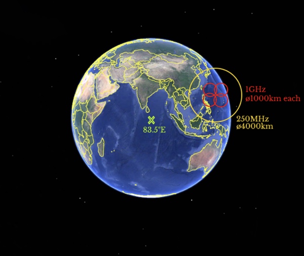 This graphic shows an estimated collection frequency range of 250 megahertz to 4 gigahertz. The interception of these frequencies enables the geolocation of search radars, microwave communications, cellular communications, and L-band transmissions such as from Inmarsat satellites. |
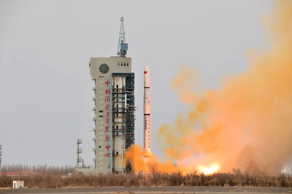
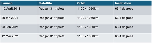
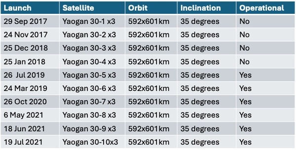
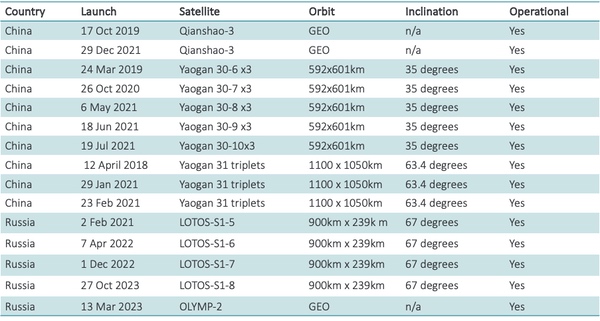
A further series of SIGINT satellites is Yaogan-31. This is a triplet constellation that fly in close formation to provide precise geolocation accuracy. The table below shows the launch dates and how quickly China was able to populate the constellation.
 |
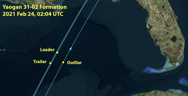 This diagram demonstrates the orbital formation of the YAOGAN-31 satellites. It has a lead, trailer, and outlier satellite to provide accurate geolocation of targets. The inclination of the orbit of 63.4 degrees enables increased revisit time of Taiwan. Source. |
China in parallel launched the Yaogan-30 constellation of satellites. This similarly consists of triplet SIGINT satellites, but in a lower inclination. The constellation includes 18 operational satellites. They do not fly in close proximity but instead are spaced apart by 120 degrees to provide more coverage in providing geolocation capability. Yaogan-30 is similar to the Naval Ocean Surveillance System (NOSS) used by the US Navy. It is likely that China has copied the frequency collection range of the US NOSS satellites, which operated between 555 megahertz and 10 gigahertz with a geolocation accuracy of two to three kilometers.
 |
The Yaogan-30 satellites are spread out in the same plane to enhance the ability to track foreign naval deployments.
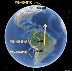
On September 10, 2023, the Yaogan-40 01 A/B/C satellites, likely SIGINT spacecraft, were launched into an 847-kilometer orbit; C is now at 787 kilometers in the same 86 degree inclination. (Final Frontier Flash – 2023 – ISR University. They are in a precise triangular formation like the Yaogan-31 triplets. This indicates this is a replacement for Yaogan-31 with two satellites maneuvering to higher orbits and the third in a lower orbit.
 |
Russian space-based SIGINT satellites
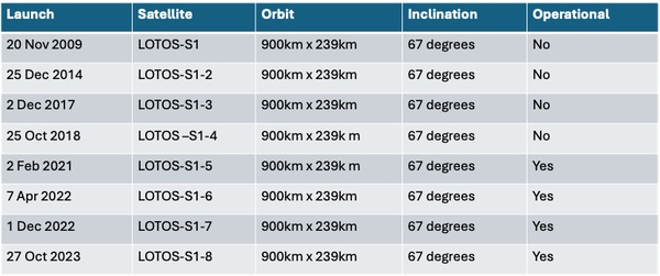
Russia has been replacing its older series of SIGINT satellites. This includes Lotos-S series of SIGINT satellites, which is part of the ocean-surveillance satellite system known as Liana. This has been operational since 2014. Liana provides SIGINT for the Russian Navy. Also included in this naval role is Pion. It was launched in 2021 after long delays from 2014 and provides SIGINT-cued synthetic aperture radar (SAR) satellite capability for the Russian Navy, as discussed below.
 These are typical orbits for ELINT satellites which are used to detect radar emissions. |
On June 25, 2021, Russia launched Pion. This is an ELINT and SAR imaging satellite likely capable of guiding Russian Navy missiles to their targets. It is part of the Liana system operated by the Russian military service ground and naval forces. The SAR capability is intended primarily for imaging naval assets. It acts in concert with ELINT sensors to locate and identify naval assets and uses SAR to image the identified asset. Pion will use its SIGINT capability to find a naval asset; once discovered, the SAR system will system will take an image. A SAR satellite alone would be incapable of discovering an asset.
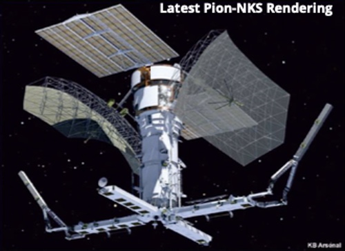 This image shows the large SAR antennas combined with the SIGINT cross shaped capabilities. This provides Russia with a potent and unique space-based targeting capability. |
In 2014 Russia launched a new series of SIGINT satellites based in geostationary orbit which similar to China’s Qianshao-1 series of satellites that provides long dwell times over a fixed point on Earth, and hemispherical coverage. The Russian Olymp-1 satellite has a 15-year lifetime design but has not changed position since the summer of 2022. This could indicate that it has little propellant left for maneuvers. Combined with the launch of Olymp-2 taking over Olymp-1’s mission, it suggests Olymp-1 is non-operational. Olymp-2 launched on March 13, 2023, and is moving around the GEO belt in close proximity to communications satellites. Olymp collects communications in C- and Ku-band.
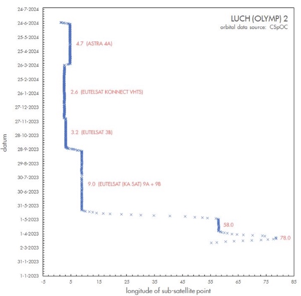 This image shows Olymp-2’s recent maneuvers tracking a Eutelsat communications satellite. It can conduct such proximity operations throughout its lifetime and intercept transmissions from other nations’ communications satellites. At present other nations are powerless to prevent Russia from conducting such operations in space. |
Conclusion
The constellations of SIGINT satellites provide both Russia and China with a focused SIGINT detection capability. The table below is a summary of the operational constellations that are capable of geolocating and targeting naval assets. While this capability is not limited to naval applications, both Russia and China use these systems primarily for naval because ground assets can be better geolocated using other ground assets.
 |
Note: we are now moderating comments. There will be a delay in posting comments and no guarantee that all submitted comments will be posted.