Staying on course: The vital role of GPS backup systemsby Lauren Miller
|
| These events thus enable a unique analysis of the real impacts of GNSS disruption at two of the largest airports in the world and a test of their resilience. |
The American Global Positioning System (GPS), the first GNSS and the only one certified for flight, serves key roles at all stages of flight, and has therefore become critical to aviation. For example, GPS, in conjunction with WAAS, allows pilots to land more safely and efficiently, and in adverse weather conditions. GPS also enables higher volumes of aircraft movements, improved traffic management and collision avoidance, and optimised fleet management of ground assets. The reliance on GPS also extends outside certified aviation applications, as aircrew, airport staff, passengers, and cargo freight are often aided by GNSS-enabled services (GPS and the complementary system of Galileo, GLONASS, and BeiDou.) GNSS is thus a critical enabler to the safe and efficient functioning of aviation in the US and globally.
While the economic impact of real-world disruption to airports has not previously been studied, a hypothetical case study of a spoofing event around London’s Heathrow Airport by London Economics in 2021 predicted minimal airside disruption due to existence of backup inputs and GNSS independent systems, but a potentially compounding impact from landside transport disruption. A similar analysis of potential disruption in the US context has not previously been published, but the UK findings can largely be adapted to US airports with some allowances for US-specific practices, such as the push to decommission non-GPS infrastructure and achieve cost savings.
In 2022, the USA saw two significant GPS disruptions at Denver International Airport (DEN) and Dallas-Fort Worth International Airport (DFW). These events involved widespread interference of Global Navigation Satellite System (GNSS) signals in the airspace in the vicinity of DEN on January 21–22, 2022, and DFW on October 17–18, 2022. GNSS is a critical part of navigation, arrivals, departures, and safety-of-life systems onboard aircraft in the US. The loss of such a key system could have severe impacts without suitable redundancies in place. These events thus enable a unique analysis of the real impacts of GNSS disruption at two of the largest airports in the world and a test of their resilience.
The cause of the disruptions to GPS
At 10:33 pm on Friday, January 21, 2022, an advisory Notice to Air Missions (NOTAM) was issued, advising pilots of widespread GNSS disruption in the area around Denver International Airport. The affected area covered a 50-nautical-mile radius around the airport, spanning approximately 8,000 square nautical miles. The Cybersecurity and Infrastructure Security Agency (CISA) have since released a report highlighting some details of the event. The report confirms the event lasted 33 hours and was caused by a source unintentionally emitting an L1 frequency signal that interfered with GPS. This interference impacted flights in the affected region at altitudes up to 36,000 feet, and also suggests the range might have stretched much farther afield, perhaps reaching 230 nautical miles from the interference source. It has not been confirmed whether the L5 signal was affected as well.
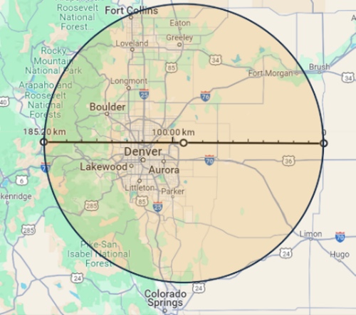 (credit: Google Maps) |
A similar Air Traffic Control System Command Center (ATCSCC) advisory was issued at 4:51 pm on Monday, October 17, 2022, warning pilots of GPS anomalies in the airspace around Dallas Fort Worth International Airport. Although original reports of the disruption suggested the event lasted for 44 hours, subsequent research by a group at Stanford University identified a more realistic timeline of significant GPS jamming from 2:21 pm on October 17, to 2:10 pm on October 18, roughly 24 hours. This spanned periods of both high and low flight traffic throughout the day and led to the closure of a runway. The source of interference was never identified, and the disruption ended without the need for intervention.
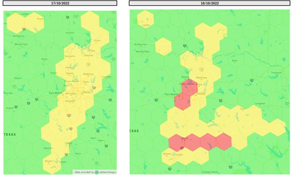 (credit: John Wiseman (2022). ‘GPSJAM’) |
The effect of the disruption to GPS
No quantifiable effect of the GPS disruption could be observed at either airport, despite the closure of a runway at DFW. For both locations, airside delays, diversions, and cancellations were comparable to the annual average, with no significant difference from the previous week, as shown in the graphs below presenting outbound flight disruptions for both airports during the disruption, alongside those for the week before, the 2023 average, and the 2022 average.
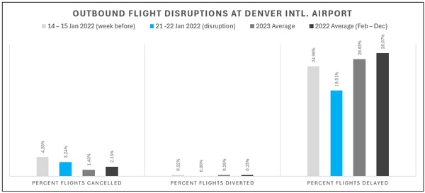 (credit: Data obtained from the Bureau of Transportation Statistics, ‘Airline On-Time Statistics’) |
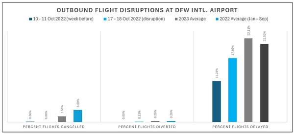 (credit: Data obtained from the Bureau of Transportation Statistics, ‘Airline On-Time Statistics’) |
Aircraft that lost GPS during approach and landing switched to backup systems such as Instrument Landing System (ILS), Very high-frequency Omni-directional Range (VOR), and Distance Measuring Equipment (DME).
The readily available backup systems at DFW and DEN, and the aircraft’s immediate ability to revert to these systems, has preserved value and prevented disruption. For a cautionary tale on what happens in the absence of such systems, one only needs to consider Tartu Airport, the second-largest airport in Estonia, whose only international route (to Finland) was temporarily suspended on April 29, 2024, due to GPS interference and lack of ground-based systems. The ongoing war in Ukraine and the repeated and widely publicized jamming activity in the area has rendered the airport, which does not have backup navigation aids, unusable. To mitigate against the disruption of service arising from the GPS interference, Tartu Airport is reinforcing GPS-independent ground navigation equipment.
| As shown in Tartu in Estonia, the impact of GNSS disruption on air transport is exacerbated when backup systems are not readily available. |
Beyond airspace operations, the expectation would be that GNSS applications within or in the vicinity of the airport would be disrupted. Ground equipment in large airports is often GNSS tracked (using GPS and often a combination of Galileo, GLONASS, and BeiDou), to improve efficiency and ensure the closest set of stairs, tug, or baggage cart is deployed to incoming aircraft. However, as many pilots reported that GPS was restored once on the ground (with only a small minority reporting that issues continued after landing), these ancillary applications are not likely to have observed a loss of GNSS.
In theory, activities in the vicinity of the airports would be affected by a loss of GNSS: for example, road transport is reliant on GNSS for optimized navigation and fleet management. A disruption to GNSS could therefore be expected to have a significant impact on traffic navigation and management within the vicinity of interference. If this were to persist for an extended period, the interruption in passenger, aircrew, airport staff, aviation logistics, and freight could be expected to have a cascading effect on airport operations, airline performance, and ultimately the supply chains that are reliant on air freight. In practice, the traffic data on these days between each airport and its two primary neighboring cities shows no sign of increased congestion in comparison to the days leading up to the disruption, as shown below.
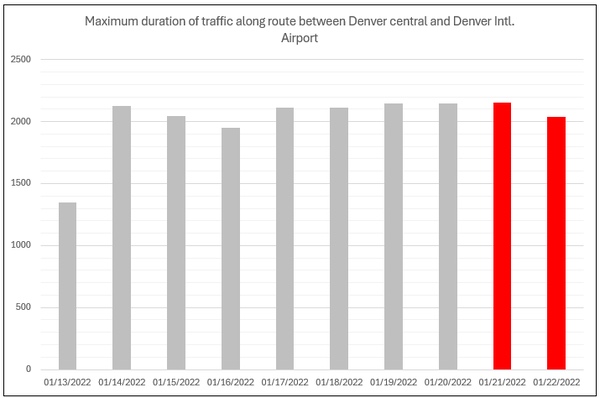 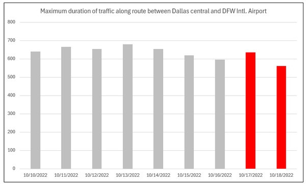 Graph of maximum travel times for this route during the disruption and the week leading up to disruption. (credit: Source: map: Google Maps. Travel times: Data obtained using Outscraper.) |
Along a similar line of discourse, GNSS not only provides navigation systems with the means to deliver accurate routing but also to alert road users to potential hazards. Drivers, particularly those visiting the city, rely heavily on directional guidance and so it is also sensible to expect an uplift in traffic accidents amid a period of GPS loss. However, the statistics of traffic accidents in the cities of both Denver and Dallas over the course of their respective GNSS outages implies that crash numbers were unaffected by interruption in both cases, as demonstrated below.
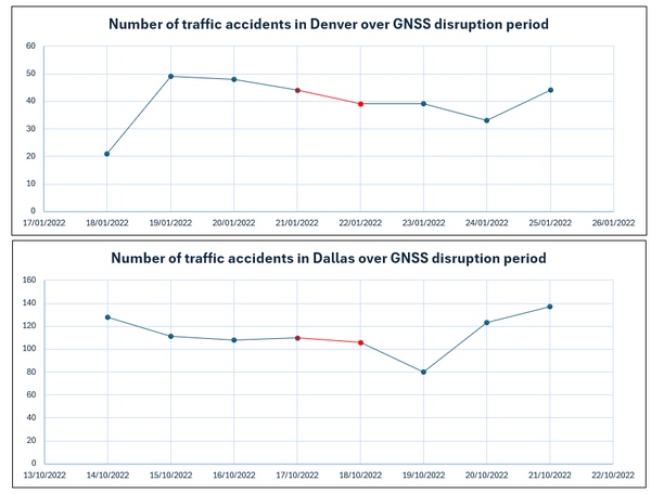 (credit: Data was obtained from the City of Denver Open Data Catalog (top) and the Texas Department of Transportation, Crash Records Information System (bottom).) |
Additionally, there is no evidence on whether L5 was affected by the disruptions. As such, ground-based applications incorporating dual-frequency receivers may have maintained continuity through the use of L5.
Conclusion
Two instances of GPS disruption at major US airports resulted in no discernible impact on operations. We can deduce two main reasons for this. First, the disruption did not reach the ground level because it was either directed upwards, or buildings and terrain shielded the ground level. Secondly, both airports, alongside smaller neighboring airports, had retained legacy ground-based navigation aids, allowing aircraft to revert to working solutions. As shown in Tartu in Estonia, the impact of GNSS disruption on air transport is exacerbated when backup systems are not readily available.
The United States intends to move towards a Minimum Operation Network (MON), which will decommission a lot of the existing infrastructure for non-GPS navigation and leave a minimum viable capacity for non-GPS navigation at a select few airports. MON airports will be spread across the country, ensuring no aircraft is more than 100 nautical miles from one. The impact of GPS disruption on aviation at DFW, DEN, and Tartu advises caution with the move towards MON. First, because the traffic patterns at the largest airports make it extremely challenging to divert to smaller sites with fewer runways and infrastructure. Furthermore, the impact of a more widespread GPS outage (e.g. space weather) would make the increased demand on MON airports from many more locations much more complex to tackle, especially with prolonged disruption.
The primary conclusion that can be taken away from the incidents at DFW, DEN, the Baltic, Tartu, and many others, is that alternative reinforcements are fundamental for locations with essential procedures that rely on GPS to operate. The lack of quantifiable impact observed in Dallas and Denver during their respective disruption periods is not representative of the potential impact of these events had alternative means of positioning, navigation, and timing not been implemented at the locations of interference.
Note: we are now moderating comments. There will be a delay in posting comments and no guarantee that all submitted comments will be posted.