Satellite reconnaissance and the Falklands Warby Dwayne A. Day
|
| What remains largely unknown and unexplored is the degree of US intelligence support to the British forces in the Falklands War. |
According to Skyhawks Over the South Atlantic, by Santiago Rivas, Cachon and his fellow pilots crossed into and out of clouds and rain that hampered their visibility, then flew over a large number of British troops on the ground. Another pilot suddenly yelled “There are the ships!” and Cachon saw “two grey silhouettes” against the coast. He began his attack and released his bombs, which hit the center of the Royal Fleet Auxiliary (RFA) Sir Galahad. Another pair of pilots hit the RFA Sir Tristram.
In total, 43 Welsh Guards and seven ship’s crew were killed in what became known to the British as “the darkest day of the fleet.” Sir Galahad burned and kept burning for days. Sir Tristram was less heavily damaged.
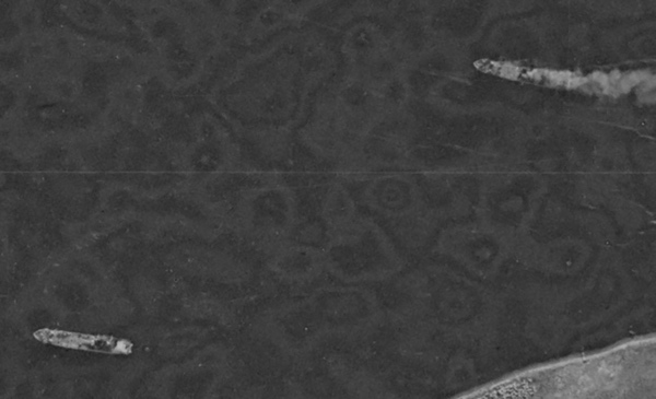
 The burning RFA Sir Galahad along with RFA Sir Tristram near Fitzroy on the eastern side of the islands. When this image was taken, Sir Galahad had been burning for five days. The ship would later be towed out to sea and sunk. RFA Sir Tristram was salvaged. Satellite photo via Harry Stranger. |
On June 13, a HEXAGON reconnaissance satellite overflew the islands. The weather was usually bad for overhead reconnaissance during the war, but on this day portions of the islands were clear. The HEXAGON photographed broad swaths of the islands. The HEXAGON could cover immense amounts of territory in a single image. Five days after the two ships had been successfully attacked, Sir Galahad was still burning, its smoke plume visible in one of the satellite’s images. But the downside of HEXAGON’s impressive capabilities was that it achieved them using film, and that film sat inside the satellite until the reentry vehicle that carried it was ejected on June 15 and recovered over the North Pacific. Then it had to be recovered, transported to Rochester, New York for development, and sent to Washington for imagery interpretation. The war ended on June 14; by the time the film showing the burning Sir Galahad reached an interpreter’s desk on June 24, the war had been over for ten days.
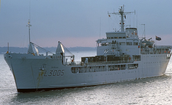 The RFA Sir Galahad before the Falklands War. British forces suffered significant losses of ships and personnel during the war. Argentina also lost several ships and had a much higher loss of life. (credit: Wikimedia Commons) |
The Falklands War
Although the history of the war has been extensively studied in the four decades since it took place, the extent of American support to Great Britain has only come to light in the past ten years or so. What remains largely unknown and unexplored is the degree of US intelligence support to the British forces. Now, more information on that subject is becoming available.
British warships sailed from ports in the United Kingdom only a few days after the invasion, but it took them several weeks to arrive at the islands. When the war finally ended several months later, the toll was clear. The Argentines suffered 649 killed, including 323 men lost when the cruiser General Belgrano was sunk by a British nuclear submarine in early May, and Great Britain suffered 258 of its soldiers, sailors, and marines killed. The Royal Navy lost two destroyers, two frigates, and three other vessels to Argentine Exocet missiles and bombs. RFA Sir Tristram was eventually transported to the United Kingdom and salvaged, but RFA Sir Galahad was too heavily damaged and was towed out to sea and sunk.
The Reagan Administration initially sought a diplomatic solution to maintain favor with Latin American countries that it was enlisting in opposition to communist influence in Cuba, Nicaragua, and El Salvador. But behind the scenes, the United States offered access to American weapons, perhaps most importantly the latest version of the Sidewinder air-to-air missile, which was hurriedly integrated onto British Harrier jump jets.
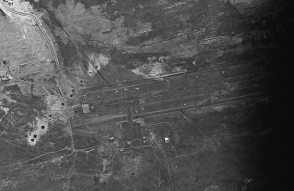 The runway at Port Stanley was seized by Argentine forces soon after the invasion. The Royal Air Force carried out long-range bombing attacks on the islands in May and June. Although damage to the runway was minimal, the attacks prevented Argentina from operating fast jets from the runway and instead launched them from Argentina, which reduced their time over their targets. Satellite photo via Harry Stranger |
American satellite reconnaissance and the war
On May 11, a Titan IIID rocket roared off its pad at Vandenberg Air Force Base in California carrying the 17th HEXAGON reconnaissance satellite. HEXAGON had first entered service in 1971, was the size of a school bus, and had earned the nickname “Big Bird,” mostly from people who did not know about the top secret satellite. The HEXAGON’s primary role was imaging large areas of the Earth to spot targets at medium resolution of approximately 30 to 90 centimeters. This was good enough to identify most military vehicles, but not sufficient to determine fine technical details—for example, it could spot a MiG-29 fighter at an airfield, but not determine if it was a single or two-seater. The HEXAGON had two powerful cameras and the film that ran through them was deposited in four satellite reentry vehicles at the front of the satellite. When a reentry vehicle was full, it was ejected and reentered northwest of Hawaii for recovery, and after the fourth reentry vehicle reached Earth about six months after launch, the satellite was useless. The time from when an image was taken until when it reached human eyes was a minimum of a few days but more likely a few weeks.
The HEXAGON joined the third and fourth KH-11 KENNEN satellites already in orbit. KENNEN satellites had a near-real-time capability, beaming their images back to the ground within minutes of taking them. The KENNENs probably had resolution about 30 centimeters at the time, and they imaged far less territory than the HEXAGON, but they were fast.
| What is now known is that a HEXAGON satellite also photographed the islands on two days: May 31 and June 13. |
In their polar orbits, the two KH-11s made multiple passes near the islands during the conflict and flew almost directly over them approximately 30 times in two and a half months. Most of their passes were to the east or west, and the satellites would have had to turn to the side to image the islands, degrading their imagery. How often they imaged the islands is unknown, although they had many opportunities. The limiting factor was most likely cloud cover: the Falkland Islands were often clouded over during April, May, and June—fall heading into winter in the southern hemisphere. British forces reported that it was usually cloudy and often rainy during much of the conflict, and the two KENNENs probably had few opportunities even when they flew near the islands.
KH-11-4 passed near the islands on May 28, but would have had to look 64 degrees off-nadir (i.e. 64 degrees off straight down), meaning that the satellite would have to turn far to the side and image at an angle through more atmosphere, degrading the imagery. But KH-11-3 also passed near the island, about 35 degrees off-nadir, a much more reasonable angle for imaging the ground. On that day the islands were relatively cloud-free.
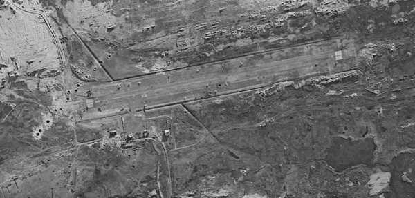 A HEXAGON image of the Port Stanley airfield taken on June 13, 1982. The craters from the Vulcan bombing raid are clearly visible. The war ended on June 14. This image did not get analyzed in the United States until June 24, demonstrating the primary limitation of the HEXAGON's film-return technology. Satellite photo via Harry Stranger |
On May 28, the National Photographic Interpretation Center (NPIC) produced a cable on “improved defensive measures, Port Stanley area, Falkland Islands.” The cable, which was declassified in 2011, reported that Argentina had improved its defensive positions around the Port Stanley area and deployed fighter and ground attack aircraft to the airfield. The Argentine forces had also constructed defensive positions on the southern outskirts of the town. They had deployed possible anti-aircraft sites on the coast to the east and erected 50 probable two-man tents as well as dug trenches. The cable does not state what satellite provided the imagery of the area, but it was most likely KH-11-3, because KH-11-4 was too far away on its passes near the islands, and the HEXAGON did not return its film until over two weeks later on June 15. Because the imagery was immediately available, it was almost certainly shared with the British government.
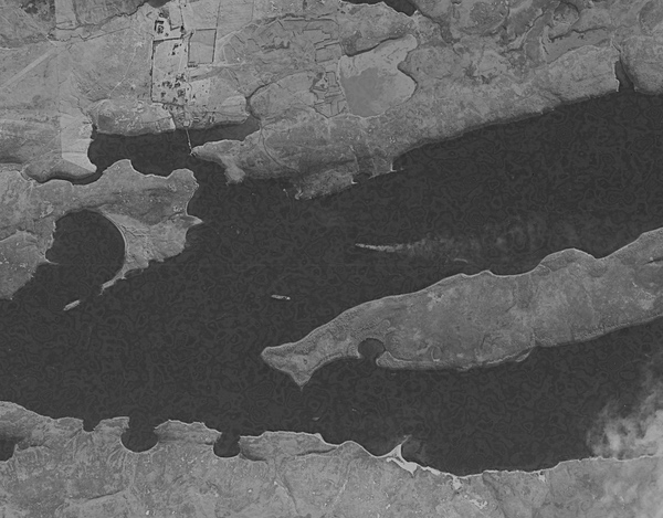
Recently, at the request of Australian researcher Harry Stranger and this author, HEXAGON imagery was obtained of the Falklands during the conflict. What is now known is that a HEXAGON satellite also photographed the islands on two days: May 31 and June 13. On May 31, HEXAGON Mission 1217 imaged all the key locations, including Royal Navy warships then engaged in deploying troops to shore. Those ships, located in San Carlos Sound, had come under attack on several previous occasions, but on this day they were not attacked.
On June 13, the HEXAGON again photographed the islands, again spotting the ships, but also spotting RFA Sir Galahad and RFA Sir Tristram on the eastern side of the islands. No intelligence cables about the British ships have been released. However, in 2011 the CIA declassified a cable from June 24 that refers to imagery “acquired on the day prior to the Argentine surrender,” i.e. June 13. That cable, titled “damage and defenses, Port Stanley, Falkland Islands,” refers to damage to the airfield and surrounding areas. The airfield had been bombed by Royal Air Force Vulcan bombers in a daring raid in May. Although the bombs barely hit the runway and it did not shut down the airfield, the attack prompted Argentina to decide not to base fighter planes on the island, which dramatically increased their distance from the attacking British forces and reduced their time over their targets. The cable continued: “Numerous craters were present throughout the area. The damage from three craters on the runway had been repaired.” (A possible reference to craters observed in the May 31 HEXAGON imagery.) “The hangar at the support area was partially damaged and one of the support buildings was completely destroyed.” Notably, the May 28 cable did not refer to destroyed aircraft at the airfield, but the June 15 cable did.
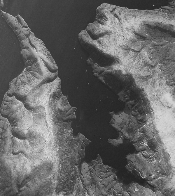 Royal Navy warships near the port of San Carlos imaged by an American HEXAGON reconnaissance satellite on May 31, 1982. This area became known as “Bomb Alley” to the British, because several ships were successfully attacked and sunk here. This image was not analyzed in the United States until after the war was over. Satellite photo via Harry Stranger |
Falklands history
The HEXAGON imagery arrived on analysts’ light tables after the war was over. The KENNEN imagery was more timely and could have had some value to British forces. It is unknown if any of the imagery was directly shared with the task force, or even if the information in the May 28 intelligence cable was shared, although it seems likely. It has also been previously reported that the United States shared signals intelligence data collected from satellites with the United Kingdom (see “Buccaneers of the high frontier: Program 989 SIGINT satellites from the ABM hunt to the Falklands War to the space shuttle,” The Space Review, November 7, 2022.) In 2011, the National Reconnaissance Office, which operated both the KENNEN and HEXAGON satellites, released a declassified film about the HEXAGON. Following a short clip of Argentine Skyhawks attacking Royal Navy ships, a HEXAGON photograph was deleted—that image was probably a HEXAGON image of ships in San Carlos Bay, which the British had nicknamed “Bomb Alley.”
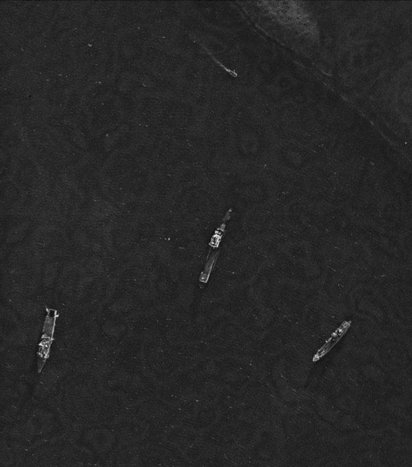 Close-up of several British ships in San Carlos on May 31. The HEXAGON imagery is sufficiently detailed to identify the types of ships. Satellite photo via Harry Stranger |
Both the United Kingdom and the government of Argentina have declassified substantial military records of the conflict, and pilots, sailors, and government officials on both sides have written memoirs about their involvement. The extent of US support to the British is still largely unknown, but these documents and photographs indicate that some new evidence is finally coming to light, over four decades since the guns went silent in the South Atlantic and the hulk of RFA Sir Galahad was sent to the bottom of the sea.
Note: we are now moderating comments. There will be a delay in posting comments and no guarantee that all submitted comments will be posted.
