Fate is in the stars: the PARCAE ocean surveillance satellitesby Dwayne A. Day
|
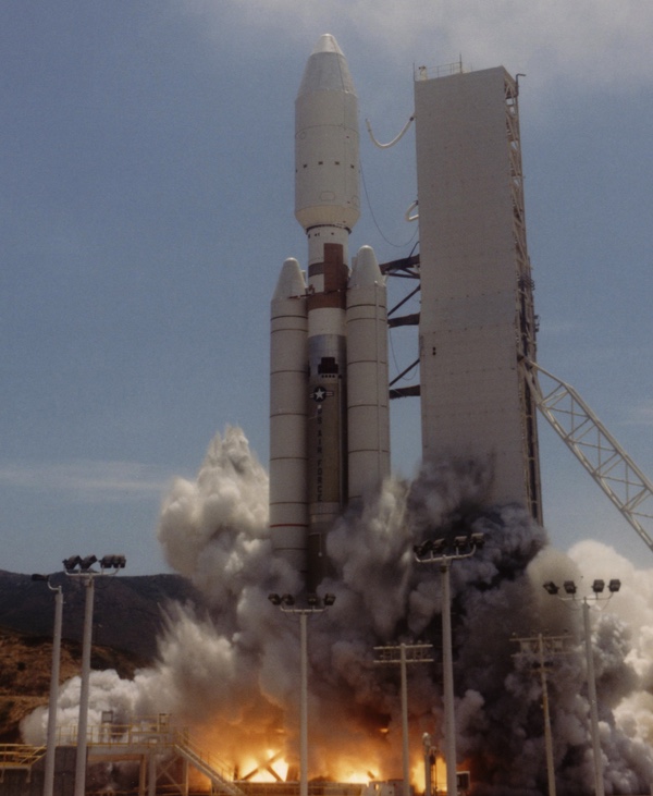
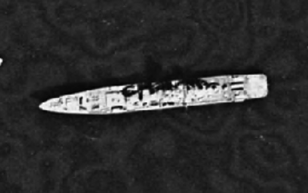
 The PARCAE satellites were based on techniques developed by the Naval Research Laboratory throughout the 1960s and a key technology was precise clocks for determining the time of intercept of signals. First launched in 1976, the PARCAE system ceased operations in 2008. (credit: NRL) |
POPPY leads the way
The Naval Research Laboratory’s first intelligence satellite program was named GRAB. Initiated soon after Sputnik, GRAB (sometimes referred to as “GREB”) was a small ball-shaped satellite equipped with a radar detector. The first successful mission was in summer 1960. As it flew over the Soviet Union, GRAB collected radar signals that it immediately re-transmitted to ground stations on the periphery of the Soviet Union. GRAB revealed that the Soviet Union had many more radars than US intelligence agencies suspected. The program was declassified in 1998.
GRAB was revamped in 1962 and became POPPY.[3] POPPY was a multi-satellite system, employing new techniques such as measuring the difference in time that a signal reached one satellite compared to another and using this information to produce better data on the location of the emitter. Eventually POPPY consisted of four satellites launched together. Like GRAB, POPPY was focused on ground-based radars primarily in the Soviet Union. But by the later 1960s, the NRL began exploring using POPPY to locate ships at sea. Until the late stages of the program, it could take weeks or more to process the data: acceptable for fixed radar emitters, but a major impediment to using satellites to track moving targets. POPPY operated until 1977 and was partially declassified in 2004. [4]
An official history of American signals intelligence (SIGINT) satellites indicates that ocean surveillance became a major mission for the National Reconnaissance Office only a few years after becoming an approved intelligence collection goal. According to a declassified NRO history of signals intelligence satellites: “By 1975 the National Reconnaissance Office SIGINT satellite world consisted of an effective set of complementary space vehicles. The low-orbiting POPPYs were busy searching for new signals and using their elegant relay techniques to provide the Navy especially with up-to-date locations of radar-equipped ships anywhere on the surface of the Earth. Going through a constant evolution from launch to launch, POPPY proved to be the best system for intercepting ship-based radars, which were sometimes only on for a few fleeting moments as the commanders used special tactics to avoid detection. This same main-beam intercept capability was immensely powerful in determining the power and scan properties of any ground-based radar that happened to illuminate the POPPY satellites.”[5]
The last POPPY launch, the ninth, took place in 1971. Whereas earlier satellites lasted in orbit for about two years, the POPPY 9 satellites lasted much longer. The program was finally terminated on September 30, 1977. By this time, POPPY had been replaced by PARCAE, designed from the start to hunt ships at sea.
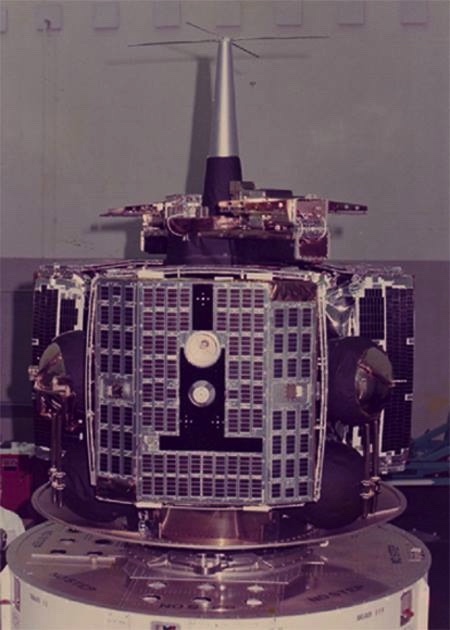
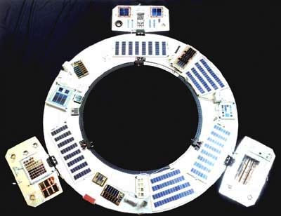
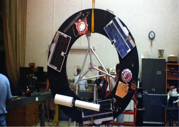
 A PARCAE ocean surveillance satellite. First launched in 1976, three PARCAEs would fly in a cluster, detecting the radar emissions from ships at sea and geolocating their positions. (credit: NRL) |
PARCAE enters service
The operation and purpose of the PARCAE space segment was consistent with the system’s codename—for just as WHITE CLOUD had not been a random unclassified designation, PARCAE had a hidden meaning as well. In Greek mythology the Parcae were three sisters, daughters of Zeus and Themida. One daughter spins the thread of fate for each mortal, while the second measures out the length of thread for each. Atropos (“the one who may not flee”) cuts the measured thread of life. It was a clever name for a trio of satellites intended to cut short the lives of Soviet warships.
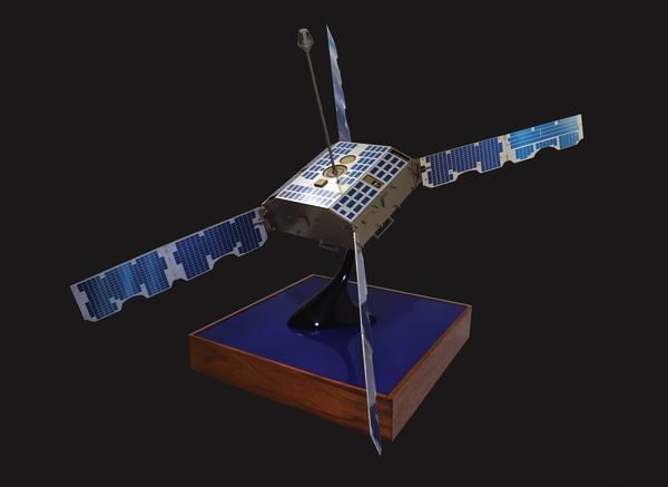
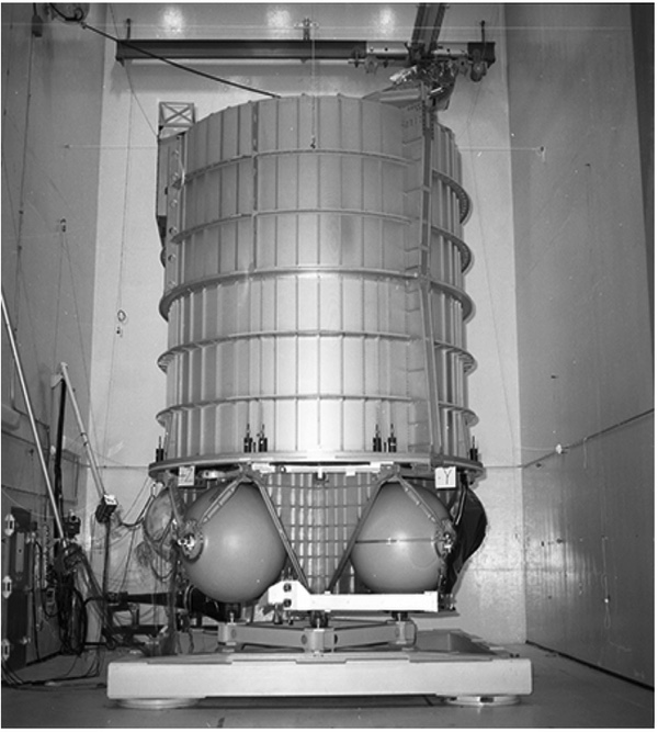
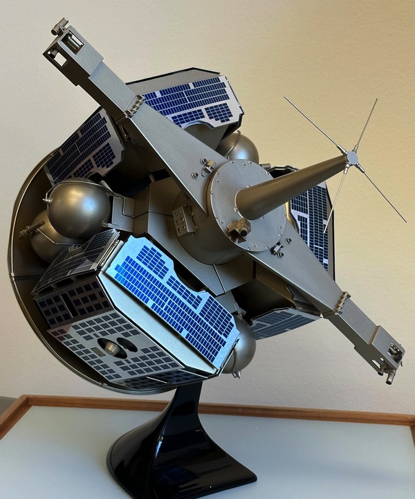 Three PARCAE satellites would be carried on a spinning Multi Satellite Dispenser which would deploy two of them, then move to a different position before deploying the third. The deployment sequence was complicated. (credit: NRL) |
PARCAE utilized a “multiple satellite dispenser” developed by Peter Wilhem and Frederick W. Raymond of NRL. The MSD had deployable thrusters on arms that folded out from the dispenser and spun it up after it was deployed from the Atlas. It was a complicated deployment system involving dozens of discrete events, each posing a single point of failure. The MSD ejected the first two satellites simultaneously while deploying a counterweight to keep spinning while carrying the third satellite to its position and ejecting it to form the triangle. Wilhelm became a legend at NRL, working for 60 years until his retirement in 2015, directing the development of more than 100 satellites.[6] Lee M. Hammarstrom at NRL developed the theoretical concept and was the program system integrator for PARCAE, leading the development of the PARCAE satellite.
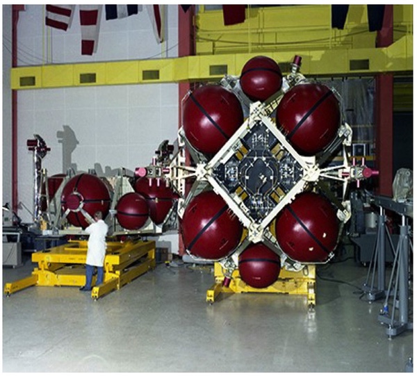
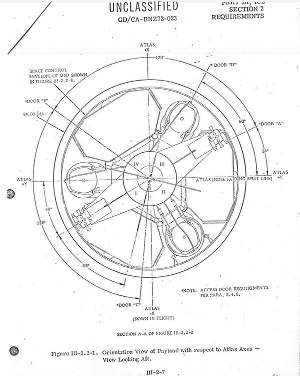 Three PARCAE satellites were carried on a Multi Satellite Dispenser atop an Atlas rocket. The MSD was responsible for placing them in their proper orbits. (credit: US Air Force) |
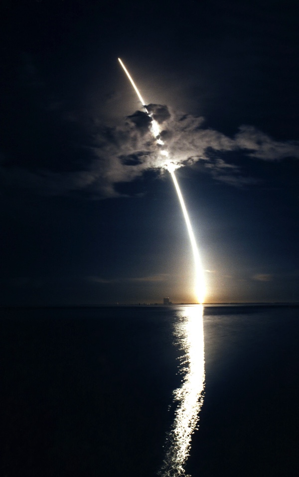
Whereas the existence of both POPPY and its predecessor GRAB remained classified for nearly four decades, PARCAE’s existence leaked to the press years before it was even launched. In August 1971, Aviation Week & Space Technology reported that the US Navy was planning an ocean surveillance satellite. On May 10, 1976, the magazine reported that a late April launch of an Atlas F rocket from Vandenberg Air Force Base carried the “Navy’s first experimental ocean surveillance satellite,” built by the Naval Research Laboratory under the code name WHITE CLOUD. A follow-up article in June indicated that a rocket had deployed three small sub-satellites into orbit, dispensing them into near-circular 700-mile (1,130-kilometer) orbits. The magazine also reported that each of the sub-satellites was “believed to carry an infrared/millimeter-wave sensor,” which was not correct.
 The second set of PARCAE satellites was launched in December 1977 on an Atlas F rocket, a converted ICBM. (credit: Peter Hunter) |
A second set of ocean surveillance satellites was launched on an Atlas F in December 1977 into a similar orbit. By July 1978, Aviation Week reported that there were three satellites in each constellation, dispensed by a carrier vehicle. Each of the satellites was separated from the others by approximately 27 miles (43 kilometers) and was capable of detecting signals from a ship’s radar up to 2,000 miles (3,200 kilometers) away. According to the magazine, whereas the first two sets of satellites had been manufactured by NRL, production of the satellites had been turned over to Martin Marietta “under direction of USAF’s Space and Missile Systems Organization, with technical assistance provided by the Naval Research Laboratory.” The magazine scored another coup on May 24, 1976, when the editors published a line drawing of the satellite.
The three individual satellites deployed long gravity gradient booms to correctly orient them towards the Earth. That technology had been developed for POPPY. On PARCAE it was possible that the satellites might orient themselves upside-down, with their boom pointing at the Earth and antennas pointed at the sky. If this happened, ground controllers pulled in the boom until the satellites rotated to the proper orientation and then re-deployed it. The satellites were equipped with highly precise, synchronized clocks, which NRL had also developed for navigation satellites, forming the basis for the GPS system. Tiny differences in time when each PARCAE satellite received the radar signals were used to triangulate the ship’s location.[7]
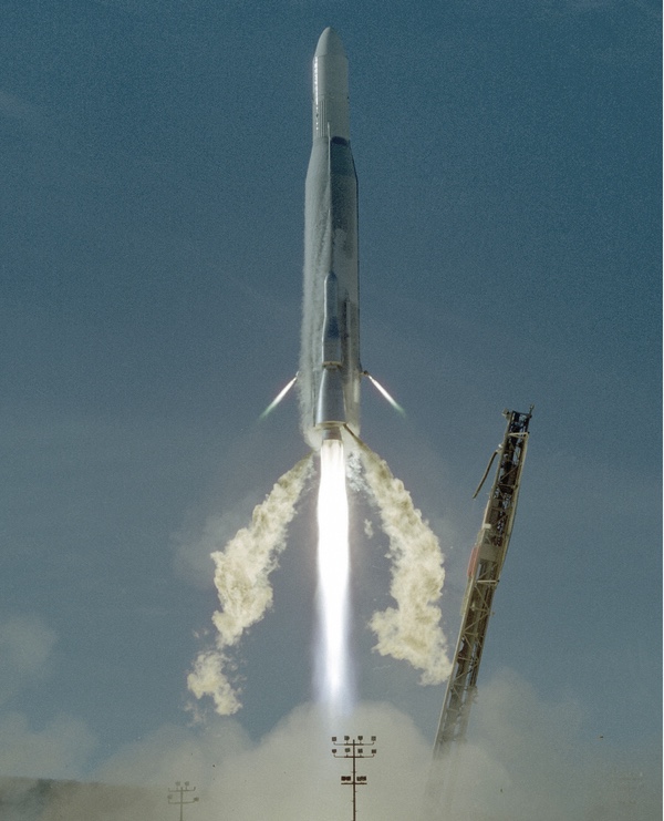
The early PARCAE satellites were launched on converted Atlas ICBMs, which saved money at first, but eventually proved costly. An Atlas F successfully placed the third PARCAE cluster in orbit in March 1980, making the system operational. But a December 1980 launch of an Atlas F with three of the satellites ended in failure. The NRO began development of the Atlas H rocket, which was essentially the Atlas launch vehicle (not a converted ICBM) but with NRL’s Multiple Satellite Dispenser on top instead of a Centaur second stage. Atlas H was used to launch more PARCAE satellites in February and June 1983, February 1984, February 1986, and May 1987. But by the 1980s, the NRO had already begun work on a much-improved PARCAE that would require an even bigger launch vehicle.
 The Living Plume Shield (LIPS) was a communications system fitted to the plume shield mounted to the Multi Satellite Dispenser. It was used for relaying intelligence information to ships at sea. (credit: NRL) |
Adding a new mission: LIPS
In the early 1980s, NRL engineers came up with an innovative solution to make use of part of the spacecraft that was normally thrown away. To protect the PARCAE satellites from the exhaust of the satellite dispenser while they were maneuvered to their final orbits, the spacecraft was equipped with a plume shield. This was then discarded after the mission. Pete Wilhelm proposed fitting it with a communications system and calling it LIPS, for Living Plume Shield. The engineers were given only six months to develop a flight version.[8]
The initial LIPS proposal appears to have been intended as a proof of concept, to demonstrate that a ship at sea could receive a signal from a satellite in a highly inclined orbit traveling in the far north. The longer-term goal was to establish a communications system for sending secure data from multiple sources through a “bent pipe” that would send that data down to users at sea or deployed in the field. LIPS-1 was launched with the primary PARCAE payload in December 1980, but the launch failed and none of the payloads reached orbit. LIPS-2 reached orbit in February 1983, and LIPS-3 was carried in May 1987.[9]
 The LIPS payload, which was deployed off the back of the Multi Satellite Dispenser, used a gravity gradient stabilization system. The boom unfolded from the disc-shaped MSD plume shield, making it look like a lollipop in orbit. (credit: NRL) |
Exactly how LIPS was used is still unclear. PARCAE’s signals apparently had to be processed on the ground before being relayed to users, and LIPS may have been used to transmit the processed signals. But LIPS may have also been intended for the relay of signals directly from the PARCAE satellites to users.
In 1984, LIPS-2 relayed data to a Spruance-class destroyer and later to the aircraft carrier USS Midway. The successful test made Navy leadership more interested in the tactical use of satellite intelligence data and LIPS-2 was designated as an operational tactical data relay system, serving for eight years.[10]
LIPS was more than simply a relay system. The NRL led the development of a specialized broadcast format that became known as TADIXS-B (Tactical Data Information Exchange Subsystem B). TADIXS-B not only utilized the LIPS payloads but was also used on FLTSAT (“Fleetsat”) communications satellites in geosynchronous orbit. When fully operational, the system enabled any user with the proper terminal to receive electronic intelligence intercepts. By the early to mid-1990s, the system was further modified to become the Integrated Broadcast System.[11] The development of LIPS and TADIXS-B and the specialized terminals for receiving the information emphasizes that the development of many systems and techniques were necessary for fully using the data. The satellites launched atop Atlas rockets were simply one part.
CLASSIC WIZARD
Although the National Reconnaissance Office and the Naval Research Laboratory have only released a limited amount of information about the PARCAE program and the satellites, they have released substantial amounts of information on other programs that help provide a better picture of PARCAE. The satellites were not covered with dishes or large antennas, and some information on the previous POPPY system indicates that they primarily intercepted the “main beams” of radars, not the fainter “side lobes” that fanned far out from either side of radar emitters. Intercepting the side lobes required dishes that could collect more and fainter signals. This also tended to limit the utility of PARCAE—it was optimized for locating and tracking ships at sea, not for identifying new and unique radar signals. Other satellites, with names like RAQUEL and FARRAH, which had dishes and other antennas, were used for that purpose.
Simultaneous detection of signals from different kinds of emitters from a single location made it possible to identify the class of ship doing the emitting and even the specific ship. This hull-to-emitter correlation was known as HULTEC.[12]
 A vandalized mural from the former Classic Wizard ground station in Adak, Alaska. Note the three crystal balls symbolizing satellite radomes as well as the three PARCAE satellites. |
The ground stations for PARCAE were all operated by the Naval Security Group Command, which had also operated the POPPY ground stations. They were located both in the United States and overseas.[13] Domestic sites had been established in Adak, Alaska, and Winter Harbor, Maine. In the Pacific, a Guam station was also part of the CLASSIC WIZARD network. Two further stations were established with the cooperation of the United Kingdom, one in Edzell, Scotland, and the other on Diego Garcia, British Indian Ocean Territory. Diego Garcia was the only station in the southern hemisphere, although it was still relatively close to the Equator. Data received at the stations could then be quickly transmitted to regional ocean surveillance centers and then, via satellite, to a main downlink at Blossom Point, Maryland.[14]
The CLASSIC WIZARD ground stations were mostly located in the northern hemisphere, and the PARCAE satellites, at least initially, apparently did not have a record and playback capability, meaning that they could not provide timely data of any vessels detected in the southern hemisphere. For this reason, PARCAE was not useful for detecting Argentine warships during the 1982 Falklands War, although another satellite named RAQUEL 1A was used for this purpose.[15]
According to several accounts of American naval intelligence, the US Navy’s ocean surveillance capabilities improved substantially during the 1970s, and satellites were a key part of that. Desmond Ball and Richard Tanger, in their 2015 essay “The Tools of Owatatsumi: Japan’s Ocean Surveillance and Coastal Defence Capabilities,” noted that a major US Navy satellite ground station was built in Japan in the early 1970s, speculating that it was connected to the new Navy Ocean Surveillance System, or NOSS. This was not a CLASSIC WIZARD station, although it may have received data collected by the PARCAE satellites and transmitted through other communications satellites as part of TADIXS-B.
Sensor-to-Shooter via Outlaw Shark
The PARCAE spacecraft launched in the latter half of the 1970s and into the 1980s would help monitor the extensive Soviet naval presence outside home waters. By 1983, Soviet deployments reached a record high of almost 60,000 ship-days, which was five percent higher than the previous peak.[16] But in addition to greater time at sea, the Soviets were also operating newer and more capable warships, like the nuclear-powered Kirov and a class of small aircraft carriers equipped with anti-ship missiles. The massive Oscar-class nuclear-powered guided-missile submarines, which began entering service in the early 1980s, were expressly developed to launch large missile salvoes at American aircraft carriers.
A 1981 CIA report stated that between 1960 and 1970, the Soviet Union began construction of eight different classes of major surface combatants. By late 1980, 17 ships of eight different classes of major surface combatants were either under construction or fitting out at Soviet naval shipyards. These included guided missile frigates, guided missile vertical/short take-off and landing aircraft carriers, nuclear-powered cruisers like the Kirov, guided missile cruisers like the Slava class, destroyers and a new type of frigate. The Soviet Union was increasing its numbers of surface combatants and submarines, and operating them farther from the motherland, increasing the demand for better ocean surveillance for the US Navy.[17]
Whereas the early years of the PARCAE satellites gave the US Navy the ability to track Soviet warships on the open ocean, by the 1980s, the goal became to use the satellites to enable the Navy to directly target ships with weapons. The 2010 NRL book From the Sea to the Stars:A Chronicle of the U.S. Navy's Space and Space-related Activities, 1944-2009 described how the US Navy in the early 1980s sought to integrate satellites directly into their warfighting. According to the book, the Naval Ocean Surveillance Information Center (NOSIC) located at Suitland, Maryland, gathered and correlated intelligence information from all sources that would be useful to the fleet. Shore-based Fleet Ocean Surveillance Information Centers or Facilities were located in each theater where naval forces operated. Information collected at these locations was then transmitted as classified messages to submarines, surface ships, and aircraft.
By 1983, the US Navy was facing a dilemma because its Harpoon and Tomahawk anti-ship missiles could reach beyond the sensor range of their launching ships. At the time, the PARCAE satellites were providing data to Regional Reporting Centers (RRCs), which then sent it to ships at sea as messages known as SELORs, for Ships Emitter Locating Reports.
Early in the PARCAE program, the locations of potentially hostile ships were plotted on naval charts with pencils. Ed Mashman, a contracted engineer who worked on PARCAE, said that in the early years, “Much of the data that had been coming in from CLASSIC WIZARD just went into the burn bag, because they could not keep up with the high volume.”[18]
The Navy sought to use the satellite data much more directly, sending it straight to shipboard computer systems. Although the details remain classified, the Navy soon adopted a new approach called the “sensor-to-shooter” concept. Instead of the PARCAE satellite data being sent to the RRCs and then to the ships, the information would be made automatically available to the weapons control stations in ships, subs, and aircraft. Navy ships and aircraft were already exchanging tactical data in near-real-time. This approach meant that more data could be delivered in useable form. The data would also go to the intelligence nodes on land to be combined with other intelligence data.[19]
This new concept required that the satellite systems collect, process, and automatically report the information. The initial plan was that space-based radar would be an additional component, but this was never developed. Captain Arthur “Art” Collier was the NRO program manager for PARCAE for six years. According to Collier, the “intercept-to-report” period had to be less than the time it took to fry an egg.[20]
The new approach required direct communications from satellites to the ships and aircraft via communications satellites. This was implemented as the Tactical Data Information Exchange System-Broadcast (TADIXS-B). It was later replaced by the Tactical Receive Equipment (TRE) and Related Applications (TRAP) Broadcast. Eventually this evolved into the Integrated Broadcast Service Simplex (IBS-S). The Ships Emitter Locating Report “evolved from crude teletype printouts derived from raw intercept data to more user-friendly forms such as automatically displayed maps.”[21]
Initially, prototype terminals known as Outlaw Shark were developed, but eventually this capability was incorporated into standard shipboard equipment upgrades. The Prototype Ocean Surveillance Terminal (POST) was also a stand-alone display system.[22]
Some participants came to think of the satellites as “orbiting peripherals,” or simply “the beginning of a complex system of complex systems.”[23] One problem with understanding PARCAE based upon the limited information released about it is that the satellites are floating in a sea of acronyms of all the associated processing and communications systems.
As the official NRL history From the Sea to the Stars has noted, this was more than just new equipment, it also required “revolutionary changes in the cultural traditions of professional communities. The fleet warfighters would have to learn to work with the satellite-generated contact reports—on occasions and under conditions selectable by individual users—as ‘tactical data’ rather than as ‘intelligence’ reports. Conversely, the national and naval intelligence communities would have to accept that, in many cases, timeliness of reporting can be more critical to tactical operators than information value added by evaluation prior to reporting. Moreover, the intelligence communities would have to recognize that Navy operators routinely evaluate tactical-data reports received, correlating these reports with information from organic sensor systems and other sources locally available.” Ships at sea had their own radars and sonars and data networks for precisely locating hostile threats, and the satellite data was one more input, albeit one that could cover huge areas of the ocean.
 The Shuttle Launch Dispenser at bottom was designed to carry three Improved PARCAE satellites to their operational orbits. It would be mounted to a large barrel that would swing the payloads out of the shuttle bay. The shuttle's tail would be located at the top of this photo. The 1986 Challenger accident led to Improved PARCAE being moved to the Titan IV rocket, and the SLD was redesigned as the Titan Launch Dispenser. (credit: NRL) |
Improved PARCAE
Even as PARCAE was switching from the Atlas F to the Atlas H in the early 1980s, the NRL began development of an Improved PARCAE system intended for launch aboard the Space Shuttle. The new satellites were to take advantage of the shuttle’s greater lifting capability. Although no details have been declassified yet, according to somebody who worked on the program, they were squat cylinders, “tuna-can” shaped. They would be mounted atop the Shuttle Launch Dispenser, or SLD. The SLD apparently had propulsion engines mounted to the ends of two deployable arms that folded out horizontally from the satellite body and used bipropellant fuel and oxidizer. Based upon the design, it was spin-stabilized.
Inside the shuttle bay, the SLD and its three satellites would be mounted atop a large barrel structure that was apparently necessary to maintain the center of gravity in launch configuration so that the heavy payload was located near the center of the shuttle’s payload bay. The combination of SLD and three satellites was the largest spacecraft the NRL had ever built, too big to fit in its test facilities. To test the balance of the system and simulate how fuel would slosh about in the tanks, NRL engineers built a sub-scale model of the barrel, SLD and satellites.
The Improved PARCAE satellites were to be co-manifested with Advanced FARRAH signals intelligence satellites that were managed by the NRO’s Air Force Special Projects office in Los Angeles. The FARRAH I and II satellites were launched in the early 1980s and were box-like. They too were also enlarged to tuna-can shapes when the program was transitioned to the shuttle.
To launch both the Improved PARCAE triplets and the FARRAH satellites in a single shuttle launch from Vandenberg Air Force Base required upgrades to the basic shuttle design. A lightweight external tank and filament-wound solid rocket boosters (SRBs) would increase the shuttle’s lifting capabilities. But the head of the program that included the FARRAH satellites realized that these improvements were unlikely to be funded in time for the first launch, if at all, and that his satellite would be short-changed. He arranged to launch FARRAHs III-V on refurbished Titan II ICBMs.[24] It is possible that after the FARRAH was removed from the shuttle, this required NRL to add the barrel below the SLD and satellites.
The explosion of the space shuttle Challenger in early 1986 led to the Air Force deciding to cancel the West Coast shuttle launch capability. This also forced the Improved PARCAE program off the shuttle. Because PARCAE was too heavy to launch on the Titan II, it had to use the more powerful, and much more expensive Titan IV rocket. It was the second time that a launch vehicle problem for PARCAE had proved costly to the NRO.
 The Titan Launch Dispenser was developed from the Shuttle Launch Dispenser after the Improved PARCAE was moved off the shuttle after the Challenger accident. A key difference was that the arms that held the propulsion engines folded down vertically on the TLD, vs horizontally on the SLD. (credit: NRL) |
The launch dispenser that NRL designed for the shuttle had to be redesigned for the Titan IV. Like the MSD developed for the earlier Atlas-launched PARCAE satellites, it too had deployable arms with thrusters on the end for spinning up the satellite stack. For the SLD version, the arms folded out horizontally. For the Titan IV version (designated the TLD), they folded out vertically.
In addition to detecting radar signals, the Improved PARCAE added collection and recognition of selected foreign communications systems. The data was provided to, processed, and reported by the National Security Agency.[25] Although other details remain classified, the satellites almost certainly were designed to have longer lifetimes than their predecessors, probably five to seven years.
The first launch of an Improved PARCAE satellite constellation atop a Titan IV rocket took place in June 1990 from Patrick Air Force Base in Florida. The second launch was in November 1991, from Vandenberg Air Force Base in California. The third launch, in August 1993, also from Vandenberg, ended in failure when the rocket did not achieve orbital velocity. According to a New York Times article, this failure cost the National Reconnaissance Office over $800 million and was particularly aggravating to members of Congress who had just cut $700 million from the intelligence community budget. In their view, the loss of the ocean reconnaissance satellites wiped out their cost cutting. However, the NRO was already procuring a new set of Improved PARCAE satellites.[26]
 The first launch of an Improved PARCAE satellite in 1990 from Florida atop a Titan IV rocket. (credit: Peter Hunter) |
The fourth and final Improved PARCAE launch took place in May 1996. The satellites, like their predecessors, were placed into orbits of approximately 1,071 by 1,046 kilometers at 64.3 degrees inclination.
The 1996 launch included a new On-Board Processor (OBP) that “provided real-time situational awareness information to military units located throughout the world.” It achieved this by enabling the receipt of the data by Navy, Army, and Air Force terminals—apparently without going through a ground station first. According to one Navy officer, “The satellites were so prolific in the amount of data they gathered that the fleet just wouldn’t be able to handle it,” without augmenting the system with new tools that could process and parse the data into actionable information.[27]
Up until that point, there was so much information coming in from the satellites that it was starting to overwhelm the users. The new system was necessary to make it manageable and useful. As the Navy put this capability into the fleet in the form of smaller, appliance-sized electronics racks, it attracted the interests of other potential users. The Navy then began working on smaller and more rugged units that could be installed in aircraft.[28]
Although details on OBP remain limited, there is sufficient information on the operations of the FARRAH low Earth orbit signals intelligence satellites to make it possible to speculate about the incorporation of OBP into the 1996 Improved PARCAE as well as later systems. FARRAH and several of its predecessors had a “direct downlink” capability that involved processing data onboard the satellite and then downlinking it to smaller, mobile “tactical” terminals operated by the Army and Air Force, as well as terminals on some US Navy warships (illustrations depict aircraft carriers, which often served as fleet flagships.) For FARRAH, that data was coming from only a single satellite. This capability may not have been available for much of PARCAE’s lifetime because a key aspect of PARCAE’s operation involved the processing and integration of signals from multiple satellites, possibly requiring multiple ground-based dishes and substantial computer power, which were beyond the capabilities of relatively simple, mobile terminals. According to one person who was involved in the negotiations with the NRO in the late 1980s about merging the ocean surveillance and low Earth orbit signals intelligence systems, a senior Army official insisted that direct downlink be included in any merged system or the Army would not support it. The OBP that flew on the last Improved PARCAE was probably the prototype for this capability for future systems.
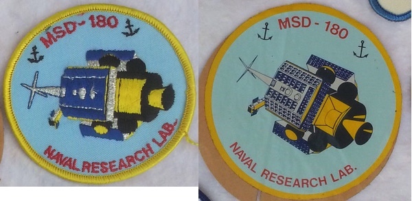 Patches showing the PARCAE satellites. These existed before the program was declassified in 2023. (credit: JB) |
TALON TOUCH/SLDCOM
The larger launch dispenser required to put Improved PARCAE satellites into orbit enabled NRL engineers to develop a new capability called Satellite Launch Dispenser Communications, or SLDCOM, which had the unclassified designation of TALON TOUCH. This was an evolution of the LIPS payload that was added to PARCAE after the first several launches. The TALON TOUCH mission was apparently initially experimental and intended to provide secure transmission of intelligence products to high-latitude regions beyond the line of sight of geosynchronous communications satellites. NRL developed SLDCOM for the Navy Space and Warfare Command (SPAWAR). It consisted of a communications payload attached to each Satellite Launch Dispenser. A normal constellation consisted of three satellites placed into higher orbits of 1,100 by 9,000 kilometers with a period of four hours. Users could expect four passes from most sites each day, with each pass being as high as 110 minutes. Uplink frequencies were 345–355 megahertz, and downlink frequencies were 250–258 megahertz. The transmission modes included digital data and FM voice, as well as multisignal and spread spectrum. SLDCOM I had a single channel UHF transponder similar to the Navy’s Fleetsat communications satellites. SLDCOM IV was planned to have a dual channel UHF transponder, but with one channel enhanced with on-board processing store and forward.
 The Soviet heavy guided missile cruiser Kirov imaged by a US reconnaissance satellite in 1980. The Kirov was designed to attack US Navy aircraft carriers. PARCAE and other systems were used to track Soviet ships like the Kirov. (credit: Henry Stranger) |
Declining threats, satellite consolidation
Thirteen PARCAE missions launched from 1976 until 1996, including failures in December 1980 and August 1993. The last PARCAE launch was in 1996. The satellites continued to operate until 2008.[19] By this time, the Soviet Union had dissolved and the Cold War ended. The former Soviet Navy fell into disarray: some ships such as the powerful Kirov and Slava cruisers were stuck at pierside for much of the 1990s. One Slava-class cruiser, Ukrayina, was launched in 1990 in Ukraine and sat unfinished at dockside, where it continues to rust away to this day. (Another one, Moskva, was later sunk in the Black Sea in 2022.) Naval deployments of Russian ships and submarines decreased to the point where they were almost nonexistent. The US Navy had far fewer adversaries to track.[30] The underwater SOSUS sonar listening arrays were decommissioned. The satellites, however, continued to fly.
By the early 1990s, the separate Improved PARCAE ocean surveillance and FARRAH electronic intelligence low Earth orbiting satellites were merged into a new program. The details of that program remain classified, although independent observers have noted multiple launches over the past decades, and clusters of only two satellites rather than PARCAE’s three.[31]
Changes in the satellites probably coincided with a new Improved Ocean Surveillance System, which From the Sea to the Stars described as “the first U.S. satellite surveillance system specifically designed for the tactical requirements of Navy and other users.” The IOSS provided “surveillance and processing of contacts everywhere in the world, reported automatically to all U.S. users, routinely, without the need to be specifically tasked (compared to the "intelligence" and "reconnaissance" systems that are focused on geographic areas based on detailed requests and tasking for collection and reporting).” It also included “all friendly, neutral, unknown, and potentially hostile contacts (compared to only the "hostile and potentially hostile" targets that comprise the defined charter of the Intelligence Community).” Ship commanders needed to know the presence and movements of all ships in an operating area to differentiate between hostiles, neutrals, and friendlies.
Data had to be updated frequently, and it also had to be provided at a classification level that could be processed by the Navy and its tactical-data systems, since not everybody who used the data would have a top secret clearance or a need to know that the data was coming from satellites. Finally, the data had to be presented in a format so that each tactical user could manipulate it based upon their own needs and local conditions.
As the threat evolved and changed, the NRO and NRL worked to provide new products that could take the intelligence data and provide it in a form that was useful and current. For instance, a new system was developed to aid in the tracking of pirates in areas where they increasingly attacked commercial shipping. [32]
For over half a century, the United States has fielded increasingly capable systems for surveilling the oceans, bringing the data they collect directly down to the captains of the ships that most need it, and into the electronic brains of the missiles they fire.
References
- “Navy Ocean Surveillance Satellite Depicted,” Aviation Week and Space Technology, May 24, 1976, p. 22; “Expanded Ocean Surveillance Effort Set,” Aviation Week and Space Technology, June 10, 1978, pp. 22-23; Mark Hewish, “Satellites Show Their Warlike Face,” New Scientist, October 1, 1981, pp. 36-40.
- Ivan Amato, “A Spy Satellite You’ve Never Heard of Helped Win the Cold War,” IEEE Spectrum, February, 2025; National Reconnaissance Office Release #9-23, “NRO declassifies early ELINT satellite program, Announcement at Naval Research Lab Centennial celebrates historic partnership, September 28, 2023; National Reconnaissance Office, “America’s Ears in Space,” September 2023.
- Amato, “A Spy Satellite You’ve Never Heard of Helped Win the Cold War.”
- Ibid.
- National Reconnaissance Office, “The SIGINT Satellite Story,” 1994, p. 255.
- Dwayne A. Day, “Above the clouds: the White Cloud Ocean surveillance satellites,” The Space Review, April 13, 2009; D.G. King-Hele, J.A. Pilkington, H. Hiller and D.M.C. Walker, The R.A.E. Table of Earth Satellites, 1957-1980 (New York: Facts on File, 1981), p. 444.
- Amato, “A Spy Satellite You’ve Never Heard of Helped Win the Cold War.”
- Ibid.
- Ivan Amato, Taking Technology Higher – The Naval Center for Space Technology and the Making of the Space Age, Naval Research Laboratory, 2022, pp. 108-110.
- Amato, Taking Technology Higher, p. 313.
- Ibid., p. 314.
- Amato, “A Spy Satellite You’ve Never Heard of Helped Win the Cold War.”
- Ibid.
- Paul Stares, Space and National Security (Washington, D.C.: Brookings Institution, 1987), p. 188.
- Ibid.
- Central Intelligence Agency, Soviet Naval Activity Outside Home Waters During 1983, August 1984, p. 1, CREST.
- “STATUS OF SOVIET CONSTRUCTION PROGRAMS FOR MAJOR SURFACE COMBATANTS, DECEMBER 1980,” February 1, 1981, CIA-RDP81T00380R000100500001-7
- Amato, “A Spy Satellite You’ve Never Heard of Helped Win the Cold War.”
- Ibid.
- Ibid.
- Ibid.
- The Applied Research Laboratory and The Pennsylvania State University, From the Sea to the Stars: A Chronicle of the U.S. Navy’s Space and Space-Related Activities, 1944-2009, 2010, p. 128
- Amato, “A Spy Satellite You’ve Never Heard of Helped Win the Cold War.”
- In 1993, three additional Titan II rockets that had been assigned to “classified payloads” were made available for other programs. It is likely that these three were originally allocated to FARRAHs VI-VIII. See Jeffrey Richelson, The U.S. Intelligence Community, 4th Ed. 1999, pp. 195-186.
- C.J. Scolese, Director, National Reconnaissance Office, Memorandum for Director of National Intelligence Under Secretary of Defense for Intelligence and Security, “Limited Declassification of PARCAE as a Signals Collection Satellite,” July 25, 2023.
- Tim Weiner, “Titan Lost Payload: Spy-Satellite System Worth $800 Million,” The New York Times, August 4, 1994, p. 1.
- Amato, Taking Technology Higher, p. 314.
- Ibid., p. 315.
- Amato, “A Spy Satellite You’ve Never Heard of Helped Win the Cold War.”
- Innovations and Innovators of the National Reconnaissance Office, 1961-2021, National Reconnaissance Office, 2023, p. 82.
- See Jeffrey Richelson, The U.S. Intelligence Community, 4th Ed. 1999, pp. 195-186.
- Amato, Taking Technology Higher, p. 314; Innovations and Innovators of the National Reconnaissance Office, 1961-2021, p. 82.
Note: we are now moderating comments. There will be a delay in posting comments and no guarantee that all submitted comments will be posted.