The Gulf states did not buy imagery independenceby Kelevitch
|
| What does a state actually need to own before it can say it can see? The answer arriving in the region is not the one the region says it is getting. |
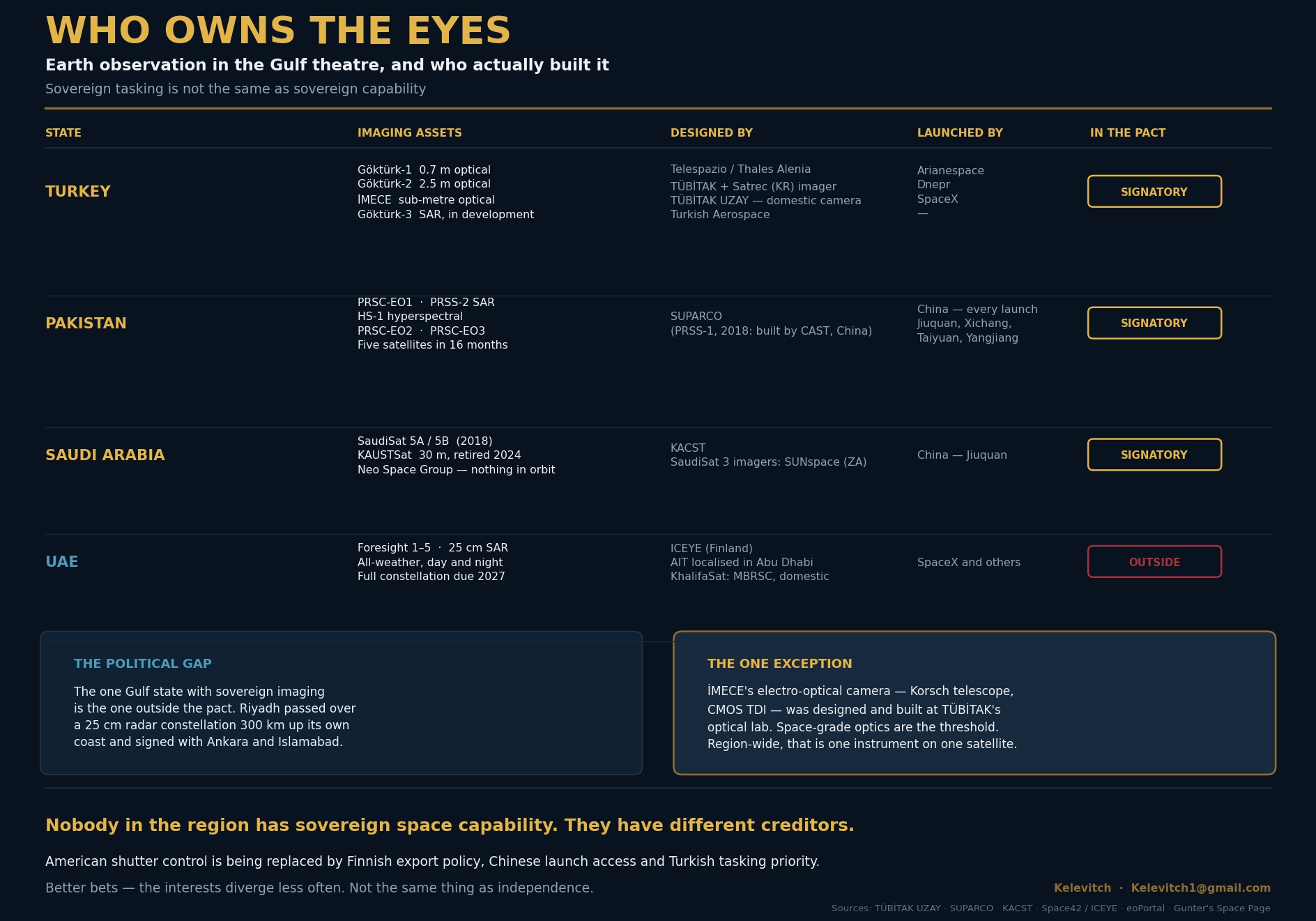
Turkey operates Göktürk-1, at 0.7-meter panchromatic resolution imager with a roughly two-day revisit over Turkish territory; Göktürk-2, which provides imagery at 2.5 meters and has been operational since December 2012 and flown by the Air Force from Ahlatlıbel; and İMECE, a sub-meter imagery satellite launched in February 2023 and taken into Air Force Command inventory as Göktürk-2B in May 2025. Göktürk-3, a synthetic aperture radar (SAR) satellite promising sub-meter all-weather imaging, is in development.
Pakistan’s record is more striking for its pace. PRSC-EO1 launched in January 2025 as the country’s first domestically produced electro-optical satellite. PRSS-2 launched in July 2025 as Pakistan’s first SAR platform. A hyperspectral satellite followed in October, along with PRSC-EO2 in February 2026 and PRSC-EO3 in April 2026. Five satellites in 16 months, two of which launched while the war was running.
Saudi Arabia’s own dedicated earth observation assets are SaudiSat 5A and 5B, launched from Jiuquan in December 2018. KAUSTSat, a 6U cubesat carrying a hyperspectral imager at 30-metre resolution, operated for 14 months from 2023 and is no longer in service. Neo Space Group, the Public Investment Fund’s commercial space champion, was founded in 2024 and has nothing comparable in orbit.
Read the pact against that and a conclusion suggests itself: Riyadh has connected itself to the two states in the Islamic world with functioning military imaging at precisely the moment it discovered that borrowed imagery can be switched off. I think that reading is broadly right, but it is missing the two things that matter most.
The state that solved it is the state that is not in the room
The first problem with the argument is Abu Dhabi. Space42’s Foresight constellation now comprises five SAR satellites at 25-centimetre resolution, offering all-weather imagery day and night. Foresight-1 launched in August 2024, Foresight-2 in January 2025, and Foresight-3, -4 and -5 went into mid-inclined low Earth orbits in November 2025, entering full operation on June 9. Imagery feeds an AI analytics platform that the company says converts raw data into usable intelligence within minutes. The full constellation is targeted for completion in 2027.
That is better than anything Turkey flies today. It is a working ISR constellation owned by a Gulf state. And yet the UAE is not in the Mecca pact.
This is where the story stops being about satellites. Abu Dhabi is, by any operational measure, the Gulf state most deeply committed to this war. The Wall Street Journal reported in July that the UAE provided targeting intelligence and defensive air cover for the Bahraini and Kuwaiti strikes into Iran. It absorbed more Iranian fire than any other country. Its ambassador in Washington wrote in March that a ceasefire would not be enough.
So, the one Gulf state with sovereign imaging, and the one with the deepest operational involvement, is outside the arrangement that the region’s other capitals built in response to the same war.
| American shutter control was replaced, or is being replaced, by Finnish export policy, Chinese launch access, and Turkish tasking priority. |
The imagery gap in the Gulf is a political, not technology, gap. Riyadh did not lack a regional partner with radar satellites 300 kilometers up its own coastline. It chose Ankara and Islamabad instead. Anyone reading the Mecca agreement as a response to a capability shortfall has to explain why the nearest available capability was passed over. The explanation is the fault line running between Riyadh, Ankara, and Doha on one side and Abu Dhabi on the other, which this war has widened rather than closed.
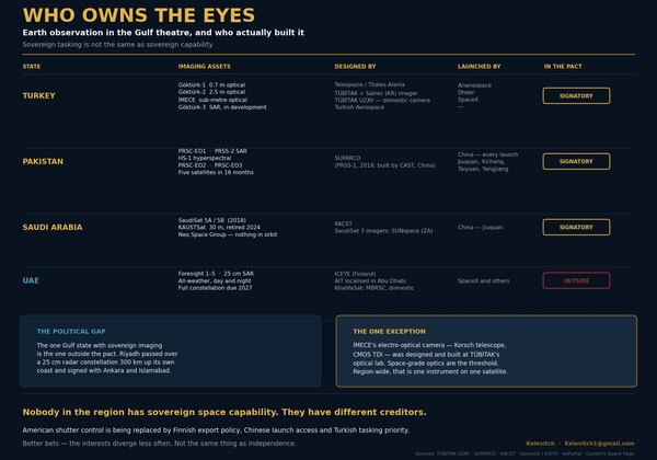 A chart of satellite imagery capabilities of countries in the region. (larger version) |
What "sovereign" survives contact with
The second problem is the word everyone in the region is using. Space42 describes Foresight as sovereign Earth observation. In the sense that matters most day to day, it is: the UAE holds the tasking authority, and nobody in Washington can switch it off. That is a real and hard-won difference from what the Gulf had in March.
But the Foresight satellites were manufactured in partnership with Iceye, a Finnish company, under a joint venture announced in December 2024. What Abu Dhabi has localized is assembly, integration, and testing—genuinely significant, and the region’s first such facility—rather than design. The company is explicit that localization is a gradual pathway. It is not yet an independent capability, and Helsinki sits inside an EU export-control regime that, as of July 13, has already demonstrated it will delay imagery over the Gulf of Oman when Washington submits a démarche.
Apply the same test elsewhere and the pattern holds. Göktürk-1, Turkey’s highest-resolution optical satellite, was built by Telespazio and Thales Alenia Space, with a payload derived from the Pléiades high-resolution imaging satellites. Göktürk-2 is a TÜBİTAK UZAY and TAI platform, but its primary multispectral imager came from Satrec Initiative in South Korea. Pakistan’s satellites are SUPARCO-built and Chinese-launched, every one of them, from Jiuquan, Xichang, Taiyuan and Yangjiang; PRSS-1, the 2018 predecessor, was built outright by China’s CAST. Saudi Arabia’s SaudiSat 3 used imagers from SUNspace in South Africa. The UAE’s DubaiSat-1 and DubaiSat-2 were built by Satrec Initiative; the Hope Mars orbiter was developed with the University of Colorado’s Laboratory for Atmospheric and Space Physics, Arizona State University, and the University of California Berkeley, and launched on a Japanese H-2A.
This is understandable. Nearly every space program in history has been built on somebody else’s components, and buying capability is how capability begins. But it does mean that the story the region is telling itself—that the war exposed a dependency and the region is now correcting it—describes the first half of the process but skips the second.
What the Gulf has done is change creditors. American shutter control was replaced, or is being replaced, by Finnish export policy, Chinese launch access, and Turkish tasking priority. Those are better bets, because the interests diverge less often and less abruptly. However, they are not the same thing as independence.
There is one clear exception, and it deserves discussion precisely because it is so rare. İMECE’s electro-optical camera was designed and built in Turkey, at TÜBİTAK’s optical systems laboratory: a Korsch-type telescope with CMOS TDI sensors developed domestically. Space-grade optics are the threshold. Buses can be bought, integration can be learned, launch can be contracted, but a sub-meter camera you designed yourself is the point at which nobody can quietly stop selling to you. That is what sovereignty looks like in this domain, and across the entire region it currently amounts to one instrument on one satellite.
Why the distinction is not academic
It would be easy to treat this as a purist’s objection. It is not, and the war showed why. Consider what actually failed between March and July. Gulf air defenses performed: the UAE alone intercepted 537 ballistic missiles and 2,256 drones by early April. Interception was not the problem. The problem came afterwards, when six states discovered they could not establish what had been hit on their own territory, could not attribute strikes, could not contest false claims, and could not assess the effect of their own retaliation.
Every one of those functions had been outsourced, and the supplier withdrew mid-conflict without notice. What made that possible was not the absence of satellites in the sky but rather the presence of a decision point outside the region.
| The question the war posed was not whether the region could obtain imagery but whether anyone outside the region could take it away. On that question, the answer has changed only by degree. |
A capability with a foreign decision point in it has not removed that vulnerability. It has moved it. If the relevant question is “who can stop me seeing?”, then the honest answer for the Gulf in 2026 is fewer people than in March, and not zero. For Foresight, the answer runs through Finland and, by extension, through Brussels. For Pakistan’s constellation, it runs through Beijing, which controls the launch manifest. For anything the Mecca pact eventually shares, it runs through Ankara’s own tasking queue, which is calculated over Turkish territory and has its own priorities in Syria, Iraq, and the Aegean.
None of those chains is likely to be pulled. American shutter control was not likely either, until March 9.
What to watch
Three things will indicate whether the region is building capability or sovereignty, and they are all observable within a year.
The first is whether the Mecca agreement produces an imagery annex. The published text says nothing about space. Turkish officials have described a ministerial committee and a secretariat based in Saudi Arabia. If capability instead moves quietly through the existing Turkish basing relationship—Tariq bin Ziyad in Doha, whatever is agreed in Syria—that tells you the arrangement is in the form of bilateral favors rather than collective capability.
The second is whether anyone in the Gulf funds domestic optics. This doesn’t mean integration facilities, constellations bought as a service, or joint ventures, but instead a national program to design and build a sub-meter space camera. Saudi Arabia has the money and, in KACST, an institution with four decades of satellite work behind it. Whether the Public Investment Fund puts capital into an instrument program or into buying more constellations is the single clearest signal of which problem Riyadh thinks it has.
The third involves positioning, navigation, and timing (PNT). Imagery answers what happened, while PNT answers where you are. There is no regional augmentation system anywhere in the Gulf, although Turkey’s national space program includes a regional positioning ambition. If the region is serious about seeing without permission, positioning is the second half of the problem, yet nobody has started on it.
The Gulf spent this war learning that its eyes belonged to somebody else. The response has been fast, expensive, and, on its own terms, effective. Riyadh will have better imagery in 2027 than it had in February, and it will have it from partners who are less likely to withdraw it.
But the question the war actually posed was not whether the region could obtain imagery. Instead, it was whether anyone outside the region could take it away. On that question, the answer has changed only by degree. The distinction between owning a capability and holding a subscription to one is the difference between a state that can see and a state that is currently being allowed to.
Note: we are now moderating comments. There will be a delay in posting comments and no guarantee that all submitted comments will be posted.