Shooting the news from low Earth orbitAn interview with Mark E. Brender, Executive Director of the DigitalGlobe Foundationby Dwayne Day
|
| We began lobbying Capitol Hill and the Executive Branch to encourage the government to let spy satellite technology move from the black world of intelligence to the white world of commerce. And when that happens, we wanted the First Amendment to protect the imagery. |
MB: While at ABC News in the early 1980’s I came across a quote in the Ladies Home Journal prediction’s column for the next 100 years. It was published in 1900. That quote got me thinking. It said, “Space Pictures: "Flying machines will carry powerful telescopes that beam back to earth photographs as distinct and large as if taken from across the street.” I began wondering why that prediction had not come true for people outside of the intelligence community. I knew that spy satellites existed since the US government launched the first one in secret in 1960. But spy satellite imagery was and is highly classified. The public or people in the media could not see that imagery. Actually, the first ever mention of the words “spy satellite” in a movie was in Ice Station Zebra in 1968 starring Gregory Peck.
So knowing wisdom is a function of time and effort and knowing what industry I wanted to get into after my career at ABC News, I formed the Radio and Television News Directions Association’s (RTNDA) “Satellite Imaging Task Force” in 1984. We began lobbying Capitol Hill and the Executive Branch to encourage the government to let spy satellite technology move from the black world of intelligence to the white world of commerce. And when that happens, we wanted the First Amendment to protect the imagery. In other words, the government could not tell you where you could or could not point your space-based camera. The government could not stamp “Secret” on what your camera could see on the surface of the Earth.
It was a long slog but all the work paid off when I left ABC News in 1998 to go work for then Denver-based Space Imaging. They were about to launch the world’s first high-resolution commercial Earth-imaging satellite, IKONOS. (It’s still operational today.) I became their Director of Washington Operations. I knew that satellite imagery could be visual truth serum for newsgathering, providing the ultimate high-shot. And the imagery is all map-accurate so it can be tied to a specific location on the Earth. Orbital cameras could keep a close-up eye on areas of the world that some countries may want to keep secret, or be able to see remote places on the planet that are hard to get to.
DD: You were in the television business, correct? How did you start out there and where did you end up?
MB: I graduated from Miami University in Ohio in 1971. Because I was in ROTC, I became an Ensign in the US Navy upon graduation. After a tour of duty at sea, I served as a Navy Public Affairs Officer and for several years as a Military Social Aide to the President at the White House. This job was a part time position in addition to my regular duties. But very rewarding and exciting just the same.
DD: What ship did you sail on?
MB: I served as the navigator aboard the USS W. S. Sims (FF-1059), a fast frigate based in Mayport, Florida, and as the US Sixth Fleet Assistant Public Affairs Officer aboard the guided missile cruiser USS Albany, home-ported in Gaeta, Italy. I might add that I flunked my ROTC navigation course in college. Both ships have since been decommissioned!
DD: I’m familiar with the Albany. The Navy had several World War II era cruisers that they converted to fire anti-aircraft missiles and the Albany had a very tall and odd-looking superstructure.
MB: I left the Navy in 1981 to go to work as an Assignment Editor at the ABC News bureau in Washington DC. But I remained in the naval reserves, got promoted, and in 1991 retired with the rank of Commander. After six years on the ABC News assignment desk I became the Pentagon Producer for the network and worked out of the very small ABC News office inside the Pentagon. I also did daily radio reports for ABC network and affiliated radio stations. I worked for ABC in the Pentagon for a decade before leaving the news industry to get into the satellite imagery business. It was just about to take off and I wanted to be part of it. ABC News has camera crews located all around the globe to cover news. I had always thought that the next logical place for a newsgathering camera was in low Earth orbit. Now I see satellite imagery in the news all the time and take great satisfaction that I had a hand in the technology and helped shape and influence US policy for the operation of commercial imaging satellites.
DD: Were you involved in using SPOT and Landsat imagery to observe the Chernobyl disaster? How did that come about?
| In looking back, I now see that the Chernobyl image was the first use of high-resolution imaging on a breaking news story, something commonplace today. |
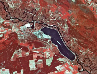
MB: On April 26, 1986, I was sitting at the ABC News assignment desk in Washington DC when media reports came across the “wire” about high radiation levels being detected in the atmosphere over Sweden and other areas of Western Europe. The first USSR reaction to Chernobyl was an innocuous 44 words more than a day later. We knew there was some type of explosion at Chernobyl in the Ukraine—that was then part of the Soviet Union. No one could or would want to fly over the area. While the Soviets closed the airspace, they could not close outer space. So, the only way to pierce the veil of Soviet secrecy was by trying to take a satellite image of the plant from the safety of non-sovereign space. It so happens that in February 1986, two months before Chernobyl, the French had launched the world’s first high-resolution commercial Earth-imaging satellite. It was called SPOT and its ground resolution was then a remarkable 10 meters. That was considered “high-resolution” at that time. At that resolution the satellite’s camera could resolve an area on the ground about half the size of a tennis court. To show you how far things have come, US commercial imagery satellite operator DigitalGlobe is currently seeking permission from the US government to build and launch an imaging system with a ground resolution of 0.25-meter, or a little less than ten inches. [DD note: classified intelligence satellites have been capable of doing this since the 1960s.]
I had attended SPOT’s official launch party at the French Embassy so I knew the executives at the company. I called the SPOT offices in Reston, Virginia, and strongly urged them to direct their new satellite to take pictures of the Chernobyl area. Since the satellite was launched in late February, the French said it was too new and not yet operational. Typically new satellites take 60–90 days to check out before they are declared operational. You can call it space-based sea trials. As a journalist, I implored them to bypass protocols and take an image. A US Landsat satellite—at a much coarser resolution—was first to take an image, but the world needed to see finer details on the ground and that would only be available from the SPOT camera. The French realized there would be tremendous public exposure for their new satellite and took an image on May 2, 1986. Once I received it, ABC was first to put it on the air. The next day The Washington Post wrote a story about this new age of Earth observation, “Civilian Satellites Penetrate Soviet Secrecy, Photograph Plant”. In looking back, I now see that the Chernobyl image was the first use of high-resolution imaging on a breaking news story, something commonplace today.
DD: In 1987 Congress’s Office of Technology Assessment produced a report on Commercial Newsgathering from Space. Do you remember that? Did you have any input into it?
MB: In the mid-’80s, I encouraged the House Science and Technology Committee to explore the issues surrounding the commercialization of spy satellite technology and First Amendment issues surrounding newsgathering from space. The Committee asked the Office of Technology Assessment to do a study. Their 50-page report was published in May 1987 and remains one of the most thoughtful publications on these issues—many of which are still unsettled today. One of those issues regards the US government’s powers under the First Amendment and the concept of prior restraint to restrict commercial imaging systems operating in non-sovereign space from imaging the Earth below certain resolutions. Another unresolved issue is whether the USG can say that super high-resolution imagery of Earth is classified if the imagery is taken from an unclassified platform. I was one of the workshop participants in this study. Richard Dalbello, who now works for the Science Advisor to the President, directed the study.
DD: Were you in any way involved in the discussions over licensing commercial satellite imagery in the US in the early-mid 1990s?
MB: As the head of the Radio and Television News Directors Association “Satellite Imaging Task Force,” we were intimately involved in all the unclassified discussions on the Hill and in the Executive Branch regarding the licensing of commercial remote sensing satellites. While I was pushing for change from the outside, there was a group of mainly Lockheed intelligence executives who were pushing from within the government. The first overture to the government to consider licensing one-meter ground resolution imagery took place in April 1990 at the old Intelligence Community staff building on F Street in Washington. This meeting took place four months after the French launched their second commercial remote sensing satellite, so there was a sense of urgency that the US was falling behind in this emerging field. Another early visionary was a man by the name of Walter Scott. He was first to get a license to operate a commercial remote sensing satellite and he’s now the Executive Vice President, Chief Technical Officer, and Founder of DigitalGlobe. In 1986, I remember writing a piece for Issues in Science and Technology, called the “First Amendment in Space: News Gathering from Satellites.” I got some eyerolls back then; people thought it was pretty far out and said such a thing would never happen. I also recall that Carnegie Endowment did a forward-looking study in 2000 called “Secrets for Sale: How Commercial Satellite Imagery will Change the World.” It looked at the all facets of this then emerging technology and concluded, “Governments that have tried to suppress and control flows of information have in the long run, suffered for it. The wiser course of action, as well as the only practical one, is to learn to live with the new transparency.”
DD: A friend of mine was involved in some of those licensing events, including a hearing on Capitol Hill. He said that there was a widespread view that the US companies that were involved, particularly Lockheed, led some members of Congress to believe that they favored licensing commercial imaging at the time, but then they torpedoed the whole process, possibly at the instigation of the National Reconnaissance Office. Do you know anything about that period?
| Sir Arthur Clarke referred to this new form of space-based information as opening the “Age of Transparency.” |
MB: The NRO participated in an interagency working group that along with others in the Intelligence Community and industry worked to develop the framework for what became the White House Policy on Commercial Remote Sensing (Presidential Decision Directive-23) released by President Clinton in March 1994. This was the policy required to commercially license high-resolution satellite technology and imagery. Lockheed was aggressive in leading the licensing legislation. This required changing the government’s long established national security policy that prohibited such commercial ventures. Other countries, like France, had no such policy restrictions. Knowing this and wanting to leverage the decades-long investment in high-resolution satellite imaging technology, Lockheed led industry in the move to commercialize this Cold War space technology. In the mid-’90s, Lockheed and Raytheon formed a joint venture named Space Imaging. The Denver-based company built and launched the world’s first high-resolution earth imaging satellite, IKONOS. Lockheed’s hope was to sell imaging satellites since they were worried that the post-Soviet Union “peace dividend” would mean the need for fewer big and expensive NRO spy satellites. Believe it or not, each spy satellite today costs more than a Nimitz-class nuclear aircraft carrier. Lockheed in Sunnyvale, California, built the IKONOS satellite in the same facility where they build satellites for the intelligence community today. The other partner in Space Imaging was Raytheon. Their interest was to sell more ground stations. Satellite imagery must be downlinked to ground stations that are located on various continents. So each of Space Imaging’s parent companies had a business reason for entering into the commercial remote sensing business. In January 2006, after Space Imaging lost two important government contracts, Virginia-based OrbImage purchased Space Imaging and the new company renamed GeoEye. Of course, DigitalGlobe purchased GeoEye in January 2013.
DD: I think that it is somewhat difficult to understand how different things looked from the mid-1980s. At the time, the US government did not discuss imagery satellites, and the combination of secrecy and lack of access made the idea of using them for newsgathering seem bizarre. Now they are openly acknowledged and the civilian ones are regularly used for a lot of purposes. In fact, we’re way beyond that. Not only does the media have access to imagery, but the public does as well. Activists regularly use them to monitor environmental disasters, like the BP oil spill in the Gulf of Mexico, and even correct the government’s assessments. They also use them to shed light on massacres and warfare in Africa and natural disasters around the world.
In addition, we now have easy manipulation of the data, so that it is possible to go from an overhead image to a street view to adding in data, like location names, and other relevant information. It’s not just a picture anymore. I think that imagery satellites have incredible value for news coverage of natural disasters, but I also think that the media often uses them just as much for cool imagery as for actual news. They love to use that zoom-in feature, even if it serves no purpose. Where do you see this heading in the future?
MB: Sir Arthur Clarke referred to this new form of space-based information as opening the “Age of Transparency.” Indeed, over time we have seen the capabilities and industry move toward his vision and my early interests to bring this technology into all aspects of the public domain. Those of us who were at this dawn are very proud of the accomplishments and we can look back on this era in space history with pride and satisfaction.
High-resolution commercial satellite imagery is now part of a vast, unparalleled democratization of humanity’s view of the world—our globe suddenly brought into focus as never seen before. It brings the death to distance and an avalanche of visual content that is useful to solve challenging problems, able to help predict the future and help media tell a more believable and compelling story.
We live in a “space-time” world now where our temporal location and movements are important to us—and others. Imagery will continue to improve; more frequent satellite revisits will enhance its temporal quality and its spectral content for better analysis of the world we live in.
Socrates said that “Man must rise above the Earth, to the top of the clouds and beyond, for only thus will he fully understand the world in which he lives.” That’s what this technology does. It helps humankind better understand the world.
DD: What are you working on at the moment?
MB: I am the Executive Director of the DigitalGlobe Foundation. The Foundation provides free high-resolution satellite imagery from DigitalGlobe to students and faculty at universities around the world to support research. The imagery comes from DigitalGlobe’s vast data archive. It contains more than 4.4 billion square kilometers of Earth imagery. That’s greater than 27 times the landmass of the Earth. The CEO of DigitalGlobe, Jeff Tarr, believes such imagery helps us see a better world and has been very supportive in under writing the Foundation. And the employees of DigitalGlobe appreciate what the Foundation does. I am also spending more time at our home in Telluride, Colorado.
DD: Thanks.