Through a glass, darkly: Chinese, American, and Russian anti-satellite testing in spaceby Brian Weeden
|
|||||||||||||||||||||||||||||||||||||||||||||||||||||||||||||||
| Remaining silent risks sending the message to China and other countries that developing and testing hit-to-kill ASAT capabilities is considered responsible behavior as long as it does not create long-lived orbital debris. |
While there is no conclusive proof, the available evidence strongly suggests that China’s May 2013 launch was the test of the rocket component of a new direct ascent ASAT weapons system derived from a road-mobile ballistic missile. The system appears to be designed to place a kinetic kill vehicle on a trajectory to deep space that could reach medium earth orbit (MEO), highly elliptical orbit (HEO), and geostationary Earth orbit (GEO). If true, this would represent a significant development in China’s ASAT capabilities. But it would not be the first instance of an ASAT weapons system designed to attack satellites in deep space, as the Russians developed at least the components of such a system in the 1990s. Thus it is more a signal that China is a new entrant into what is an old game, and while there is some knowledge as to what capabilities China may be developing, why they are developing those capabilities is still unclear.
In June 2013, I argued that the Obama administration should release more information publicly about China’s ASAT program and testing in space. Following China’s purposeful destruction of its FengYun 1C (FY-1C) satellite using a direct ascent ASAT weapon in 2007 and the resulting creation of more than 3,000 pieces of trackable space debris, the public information released by the United States played a major role in mobilizing international outrage about the test. This international criticism, combined with the United States’ destruction of its own USA 193 satellite the following year, arguably resulted in a change in Chinese behavior. Subsequent tests of the same SC-19 system in 2010 and 2013, characterized by China as missile defense tests, targeted suborbital targets and did not result in the creation of any long-lived space debris.
Going public about the testing of a potential new Chinese ASAT test could lead to similar political pressure on the Chinese government, particularly if they plan to conduct another destructive test in the future. Remaining silent risks sending the message to China and other countries that developing and testing hit-to-kill ASAT capabilities is considered responsible behavior as long as it does not create long-lived orbital debris. That message would likely encourage the proliferation of ASAT capabilities, increasing the threat to the space assets of all States, and thus contributing to greater political and strategic instability in space and potentially on Earth.
To date, the US government’s public response to and information about China’s ASAT testing activities has been relatively muted. The US government remained silent about 2005 and 2006 tests of the Chinese ASAT system designated SC-19 by the US government. The existence of those tests was only made public after the 2007 test of the same system. Following the 2010 test of the same system, a US government official stated that they “detected two geographically separated missile launch events with an exo-atmospheric collision also being observed by space-based sensors.” Confirmation that this was indeed another test of the same SC-19 ASAT system comes from a classified State Department cable that was leaked by Wikileaks in 2011. In January 2013, China publicly reported another “mid-course missile interception test” that many have concluded is yet another test of the SC-19 system based on the similarities of its description by the Chinese media to the 2010 test, but it has not been publicly declared as such by the US government.
The US government has provided a single official quote regarding the May 2013 launch, stating that “the launch appeared to be on a ballistic trajectory nearly to [GEO]. We tracked several objects during the flight…and no objects associated with this launch remain in space.” The 2013 report of the U.S.-China Economic and Security Review Commission to Congress mentions the May launch and the claims about it being an ASAT test, but provides no new evidence to support those claims. Public statements from multiple US officials, including Director of National Intelligence (DNI) James Clapper, mention increasing threats to U.S. national security space assets and China’s ASAT program but provide no details. A January 2014 hearing convened by the House Armed Services Committee (HASC) focused on the challenges China’s counterspace program poses for US national security and potential strategies for addressing those challenges, but yielded no new facts or information about the May 2013 test or China’s actual ASAT capabilities either. A March 2014 hearing convened by the Senate Armed Services Committee (SASC) discussed the Pentagon’s strategy to deal with the growing ASAT threat but no specific details.
The purpose of this article is to place more information about the May launch and other Chinese ASAT testing into the public domain and also in the context of other known ASAT testing activities by the United States and Russia. The hope is that this information will spur both more openness from the US and Chinese governments and spark public debate on this issue by reducing the possibility that doing so would reveal intelligence sources and methods. However, it is possible that the US government will still remain silent despite the newly available public information. That would suggest other rationales for the silence, such as not wanting public discussion of the ASAT testing to jeopardize potential bilateral discussions with China on space security issues. It may also be that the United States does not want criticism of Chinese ASAT testing to lead to a norm that testing and developing ballistic hit-to-kill systems is irresponsible, which in turn would undermine the political support for the United States’ own Phased Adaptive Approach (PAA) midcourse missile defense system, which uses the same technologies. Creating such a norm would also constrain the United States from developing its own hit-to-kill ASAT capabilities again in the future. If that is the position of the United States, it would be very troubling as it would almost certainly lead to a proliferation of more ASAT capabilities that further increase the threats to all space systems, including those of the United States, and undermine political and strategic stability in space.
| Both the United States and China agree that something was launched from Xichang on May 13, 2013. Discovering what rocket was used could help evaluate what actually happened. |
The first section of this article analyzes the May 2013 launch from Xichang and attempts to determine why it was characterized by the U.S. government as an ASAT test. A critical part of this analysis utilizes commercial satellite imagery and information from Chinese bloggers and the Chinese public. The second section provides a summary of American and Russian ASAT testing in space from the late 1950s to the present. This section provides important context for the Chinese ASAT testing in that it shows the ASAT technologies and techniques developed and tested by all three countries are very similar in nature, and that efforts to develop means of attacking satellites have gone hand-in-hand with the development of satellites themselves. The third and final section examines the parallels between hit-to-kill ASAT testing and midcourse missile defense and the political difficulty in proscribing one but not the other. It also examines the role that the culture of secrecy plays in the public silence over this issue, and how that may cause more harm than good over the long-term. The article concludes with a call for greater transparency and confidence building measures by all countries, and in particular the United States and China, to enhance strategic stability in space and on Earth.
Assessment of the May 2013 launch From Xichang
In an attempt to evaluate what happened, a good place to start is with the rocket that was launched. Both the United States and China agree that something was launched from Xichang on May 13, 2013. Discovering what rocket was used could help evaluate what actually happened. Neither the American nor Chinese official statements mention specifics, although the official press release from the Chinese government described the launch as that of a sounding rocket carrying a Kunpeng-7 scientific payload to conduct high-altitude experiments. Sounding rockets are rockets designed to carry instruments or small scientific payloads on suborbital flights. Typical missions for sounding rockets include scientific research of the upper atmosphere, the ionosphere, or the Van Allen radiation belts. Sounding rockets are typically much smaller than their orbital cousins and reach altitudes in the tens or a few hundreds of kilometers or miles. In this particular case, a representative of the Chinese Academy of Sciences was quoted in a later news story stating that the launch involved the release of a cloud of barium powder at an altitude of 10,000 kilometers to study the magnetosphere.
Mystery rocket
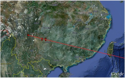 Figure 1. Launch trajectory from the NOTAM (Source Spaceflight101.com) Image © 2013 Google Earth. |
To assess these statements, some information can be gleaned from the Notice to Airman (NOTAM) that China released earlier that month and updated just prior to the launch. NOTAMs are typically provided publicly to alert air traffic of rocket launch activity as a safety precaution. In this case, the NOTAM indicated a launch trajectory very similar to that of orbital launches to GEO from Xichang, as shown in Figure 1. However, analyst Patrick Blau concluded that both the time of the launch and the warning area provided in the NOTAMs were unusual for any of the Long March rockets typically used for orbital launches to GEO. The late evening (9 pm local) launch time resulted in some spectacular reports from individuals as far as away as Hong Kong and several photos published online showing a massive rocket plume, much larger than typically associated with a sounding rocket. One of these photos is shown in Figure 2, labeled by the individual who took it as a “failed rocket” because of the unusual size and intensity of the plume.
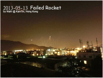 Figure 2. Image of the May 13 launch from Xichang taken from Hong Kong (Image credit: Wah!) |
Despite their relatively small size, sounding rockets are still fairly large. The Canadian-designed Black Brant XII, capable of lofting a small payload of a few hundred kilograms (650 pounds) as high as 1,500 kilometers (930 miles), stands more than 18 meters (60 feet) tall. Because of their size, sounding rockets, like orbital rockets, are typically launched from fixed locations known as “pads” with dedicated support facilities. These facilities often include an umbilical tower that provides fuel, electricity, and access to a rocket and spacecraft and a service tower with cranes and elevators to assist in the stacking and mating of a rocket and payload. Furthermore, different types of rockets usually have their own dedicated pads because of their unique size or support requirements. The size and intensity of the plume from the May 2013 launch has led some to suggest that perhaps a Long March space launch vehicle (SLV) was used instead of a sounding rocket. Xichang is the main Chinese launch center for space launches carrying satellites to GEO orbits using the Long March 3B (LM-3B). If the May 13 launch did use a LM-3B, it would need to originate from the launch pad at Xichang designed for Long March rockets, designated Launch Complex 2 (LC-2). This pad is located at 28.245547°N latitude and 102.026811°E longitude.
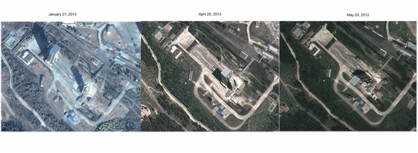 Figure 3. Imagery of LC-2 at Xichang. Images © 2013 Google Earth. |
Figure 3 shows a series of satellites images from Google Earth of the LM-3B pad before and after May 13, 2013. The image from January 21, 2013, shows the servicing tower rolled back from the umbilical tower and a LM-3B sitting on the pad next to the umbilical tower. The servicing tower is closed up against the umbilical tower in the photos from April 20 and May 20. Publicly available launch records indicate that the orbital launches from Xichang around this time were that of a Long March 3B Enhanced (LM-3B/E) carrying Chinasat-12 to geosynchronous transfer orbit (GTO) on November 27, 2012; a LM-3B/E carrying Chinasat-11 to GTO on May 1, 2013; and a LM-3B carrying the Chang’e-3 lunar orbiter to Earth-Moon transfer orbit on December 1, 2013. Thus, it is likely that the image from January 21 shows the initial stacking and preparations of the LM-3B/E used for Chinasat-11.
If this is the case, it leaves only twelve days between the Chinasat-1 launch on May 1 and the unknown launch on May 13. Stacking and preparing a LM-3B or any SLV for launch in this timeframe is not feasible. Furthermore, it seems highly unlikely that China would use a relatively expensive (and overpowered) SLV like a Long March for what they stated was a simple scientific experiment. Combined with the information provided by the NOTAM discussed earlier, it is highly unlikely that a Long March SLV was used on the May 13 launch or that the launch occurred from that pad. Knowing that something launched from Xichang on May 13 leads to the question of what was launched from where within the Xichang complex. Officially, there are only two launch pads at Xichang. LC-2, as previously described for LM-3B launches, and Launch Complex 3 (LC-3) located just to the northeast of LC-2. LC-3 was previously used for the Long March 3A (LM-3A) and is currently undergoing renovations. Thus it is unsuitable as a candidate launch pad for the May 2013 launch.
Thus, it may be that there are additional launch pads at Xichang that are not officially recognized. One consistent way to identify pads that are used for launching rockets is to look for lightning masts. A tall, metal rocket sitting out in the large flat area is almost certain to attract lightning strikes that can damage internal systems or potentially even destroy the rocket. To combat this, tall metal towers known as lightning masts are placed around launch pads to attract any potential lightning strikes away from the rocket and divert them to ground. These masts are usually spaced around the launch pad to provide equal coverage. Figure 4 shows three lightning masts around Pad 39B at NASA’s Kennedy Space Center in Florida.
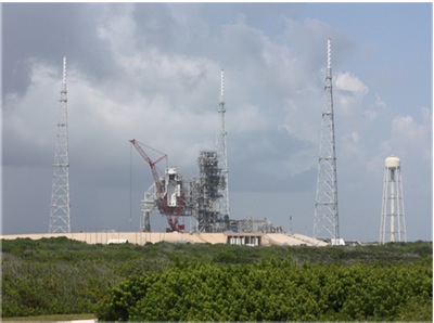 Figure 4. Lightning masts at KSC’s Pad 39B. Image credit Wikimedia Commons (source). |
Figure 5 shows a larger image of the entire Xichang launch complex with lightning masts highlighted with red circles. The lightning masts can be clearly identified by their elongated triangular shape, which can occasionally take the form of a “V” if the angle of the image shows both the tower and its shadow. Two sets of three large masts can be clearly identified around LC-2 and LC-3, as expected. However, there are also sets of smaller masts located near flat concrete areas located to the northwest and southeast of the main pads. These appear to be additional launch pads, although they lack the traditional towers and other support structures that typical SLV launch pads have.
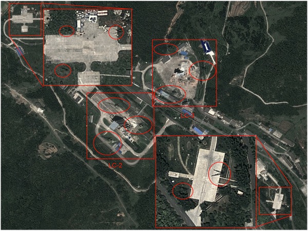 Figure 5. Lightning masts at Xichang (circled in red). Image © 2013 Google Earth. |
One clue as to the possible function of these pads comes from the timing of their construction. Figure 6 shows the history of the northwest pad based on historical imagery from Google Earth. As of April 2005, the northwest pad did not exist. The pad, rectangular in shape with its long side aligned roughly east-west, was created sometime between April 2005 and November 2005 along with three small support buildings to its south and east. As of 2012, a number of cylindrical objects are visible along the north edge of the pad. Also, a large support building has been added to its southwest, along with an access road connecting it to the pad. The image from April 2013 shows what looks like a cloud sitting on top of the pad, but in reality is likely to be the result of a firefighting test, with the white material consisting of firefighting foam that is emanating from a small truck at its lower left corner.
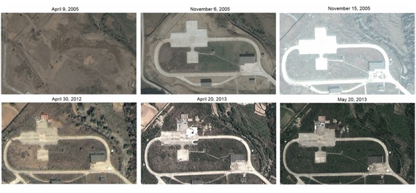 Figure 6. Historical images of the northwest pad at Xichang. Images © 2005, 2006, 2012, and 2013 Google Earth. |
In 2007, Dr. TS Kelso presented a paper at the Advanced Maui Optical and Space Surveillance (AMOS) Conference where he speculated that this northwest pad was built for the testing of a Chinese direct ascent ASAT weapon system, designated SC-19 by US intelligence. The SC-19 is thought to be based on the DongFeng-21C (DF-21C) road-mobile intermediate-range ballistic missile (IRBM). It was first tested on July 5, 2005, and again in 2006 and 2007, all from Xichang. The 2005 and 2006 tests did not have any known targets. The 2007 tested destroyed the Chinese FY-1C weather satellite at an altitude of 860 kilometers (534 miles), creating more than 3,000 pieces of trackable orbital debris that will remain in orbit for decades if not longer. The timeline for the creation of the northwest pad could possibly fit with these testing dates, although additional imagery of the location just prior to the July 2005 test would be necessary to confirm the pad was finished in time.
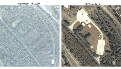 Figure 7. Historical imagery of the southeast pad at Xichang. Images © 2006, 2012 Google Earth. |
Figure 7 shows the history of the southeast pad at Xichang, which is similar in nature to the northwest pad in that it has a large concrete area connected by service roads to multiple buildings. The main difference is that it is somewhat thinner in shape and its long side is orientated almost north-south. This southeast pad was built sometime after November 2006 and before April 2013. This alone does not indicate much. However, an additional satellite image purchased from DigitalGlobe and shown in Figure 8 clearly shows a raised transporter-erector-launcher (TEL) located on the southeast pad just weeks prior to the May 2013 launch. A TEL is used as the chassis and launch infrastructure for road-mobile ballistic missiles in place of a fixed launch pad.
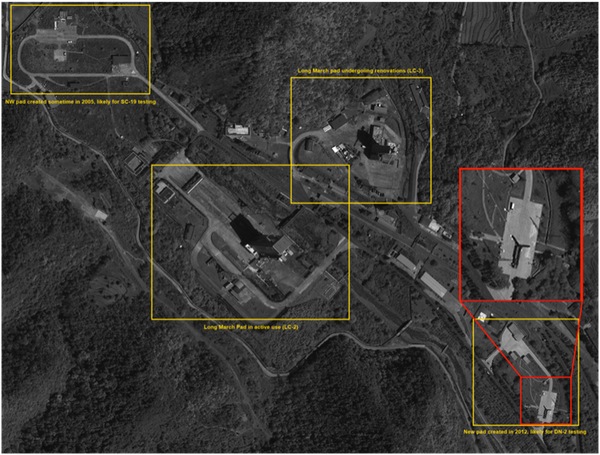 Figure 8. Imagery of Xichang from April 3, 2013, showing a TEL on the southeast pad. Image © 2013 DigitalGlobe. All rights reserved. For media licensing options, please contact info@swfound.org. |
The image does not have enough spatial resolution to clearly identify what the missile or TEL is, but measurement of its size and the conical top appears to be similar in size and shape to the DF-21C TEL shown in Figure 9.
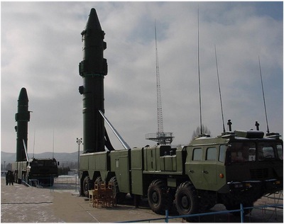 Figure 9. DF-21C TEL elevated for launch. (Image credit: Air Power Australia) |
The absence of a viable sounding rocket or SLV at Xichang and the presence of a TEL on a newly-constructed mobile launch pad gives significant credence to the claims regarding the mobile nature of the Chinese direct ascent ASAT system. It supports, but does not conclusively prove, the theory that China is using a mobile ballistic missile as the basis for its direct-ascent ASAT system. The presence of a second mobile pad at Xichang also suggests that China has begun testing a second, new system that is fundamentally different from the SC-19. The differences in orientation between the northwest and southeast pads also suggests either a larger TEL or a different flight trajectory is involved in the testing of the new system.
Altitude and re-entry
The key difference between the claims made by the US and Chinese governments about the May 13, 2013, launch is in the altitude the test reportedly reached. The Chinese press releases mention that it reached an altitude of 10,000 kilometers (6,200 miles), although it is not clear if that was the apogee of the trajectory. In contrast, official US government comments to the press stated that the launch “appeared to be on a ballistic trajectory nearly to geosynchronous Earth orbit (GEO).” While this leaves open the question as to exactly what is meant by “nearly to GEO,” it is clearly a reference to a much higher altitude than 10,000 kilometers. For the purposes of this article, we will assume that “nearly to GEO” means somewhere near 30,000 kilometers (18,600 miles).
| The rocket must have had an apogee much higher than 10,000 kilometers for it to have been in flight long enough for the Earth to rotate underneath it and the objects from the launch to land in the Indian Ocean. |
Currently, there is no publicly available data source that could be used to confirm how high the launch actually reached. However, it is possible to test whether or not the launch could have reached an apogee of 30,000 kilometers by comparing the re-entry location with the flight time required to land in that location. US officials stated that objects from the launch “re-entered the Earth’s atmosphere above the Indian Ocean.” Figure 10 shows the area commonly defined as the Indian Ocean. While the potential area is quite large, this piece of data is still useful to help evaluate these claims.
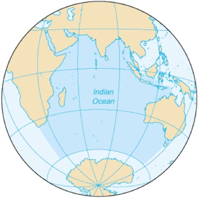 Figure 10. The boundaries of the Indian Ocean. Image credit Wikimedia Commons |
If we assume that the launch re-entered somewhere in the Indian Ocean near the Equator, then we can use that information to draw a rough estimate of the rocket’s trajectory. An analysis by Dr. David Wright from the Union of Concerned Scientists projects the flight path along the trajectory given by the Chinese government in their NOTAMs to the Equator, a distance of roughly 7,200 kilometers (4,500 miles). In order to have the rocket land in the Indian Ocean, it needed to be in flight long enough for the Earth to rotate underneath it. As shown in Figure 11, a rocket launched from Xichang to the Equator on a non-rotating Earth would land at Point A whereas with a rotating Earth it would land at Point B. The distance between points A and B is roughly 8,500 kilometers (5,300 miles), which means it would take the Earth roughly five hours to rotate that distance.
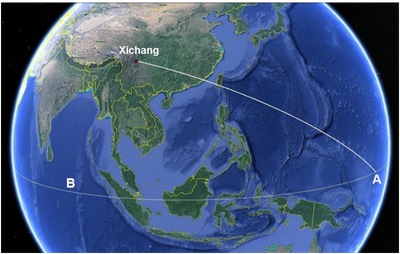 Figure 11. The ground track of a rocket from Xichang for a non-rotating Earth indicated by Point A and a rotating Earth indicated by Point B (source). Image © 2013 Google Earth. |
Using a LM-3 SLV as a reference, Dr. Wright calculates that a flight along the trajectory shown in Figure 11 to an apogee of 10,000 kilometers results in a flight time of only two hours. However, an apogee of 30,000 kilometers results in a flight time of 6.7 hours. This implies that the rocket must have had an apogee much higher than 10,000 kilometers for it to have been in flight long enough for the Earth to rotate underneath it and the objects from the launch to land in the Indian Ocean. Thus, if one takes the US government at its word regarding the re-entry location over the Indian Ocean and assumes it was referring to something other than the very northern portion, then that re-entry location is much more consistent with an apogee of 30,000 kilometers rather than of 10,000 kilometers.
An important point is that both the US government and Chinese government statements regarding the altitude of the test could be technically accurate. The Chinese statement says that the Kunpeng-7 payload released a barium cloud at 10,000 kilometers (6,200 miles) but does not specifically say that altitude was the apogee of the flight. It is entirely possible for there to have been a scientific payload on this launch which did indeed release an experiment at 10,000 kilometers on its way to a much higher apogee near 30,000 kilometers before re-entering over the Indian Ocean. That would serve two purposes: providing a payload for the rocket test and providing a scientific cover story. If so, this would certainly not be the first time a scientific program has been used as the cover story for a secret military program. During the late 1950s and early 1960s, the United States used the Discoverer scientific program as the cover for its Corona surveillance satellite program.
The other important question is whether or not any of the Chinese mobile ballistic missiles could reach such a high apogee. A typical rule of thumb is that the apogee a ballistic missile can reach is approximately one half of its maximum horizontal range. A DF-21C IRBM has an estimated maximum horizontal range of 2,500 kilometers (1,550 miles), meaning that it could reach an altitude of approximately 1,250 kilometers (775 miles) when fired straight up. Even China’s newest and most powerful ballistic missile, the DF-31A ICBM, has an estimated maximum horizontal range of only 12,000 kilometers (7,500 miles) with a 600-kilogram (1,300-pound) payload, meaning that it could theoretically reach an altitude of 6,000 kilometers (3,700 miles) or so. It is theoretically possible for a DF-31A with a very light payload to reach the 10,000 kilometer altitude claimed by China, but not possible for it to reach the apogee near 30,000 kilometers claimed by the United States.
A final set of clues comes from a February 2014 blog posting on SinoDefence.com that examines another Chinese launch from September 25, 2013. That launch took place at the Jiuquan Satellite Launch Center located in northwest China, close to the Mongolian border. Chinese media reports at the time noted that the launch placed a small remote sensing satellite into orbit, which was subsequently tracked and cataloged by the US military. The launch vehicle was named Kuaizhou, or “Quick Vessel,” and further media reports revealed that it was a new solid-rocket SLV developed as part of a Chinese Operationally Responsive Space (ORS) program. As with the American ORS program, the goal is to develop a launch vehicle and payloads that could be procured, mated, set-up, and launched much more quickly than the months to years that it normally takes. This would allow for more rapid replenishment or replacement of satellites.
Citing a Chinese researcher and blogger named “kktt,” the SinoDefence blog post goes on to explain the development of the Kuaizhou SLV. Chinese rocket development is centralized in two state-owned corporations. The Chinese Aerospace Science and Technology Corporation (CASC), and specifically its Academy of Launch Vehicle Technology (CALT), is responsible for the Long March family of SLVs, silo-based DF-4 and DF-4 ICBMs, and the DF-31/DF-31A ICBMs. The Chinese Aerospace Science and Industry Corporation (CASIC) is responsible for nearly all of China’s tactical ballistic missiles, including its DF-21 IRBMs.
According to kktt, CASIC sought to leverage the DF-21 and its expertise in solid rockets to develop a new line of solid rocket SLVs. The first attempt was the Kaituozhe 1 (KT-1), a four-stage rocket 13.6 meters (44.6 feet) in length and 1.4 meters (4.6 feet) in diameter that was designed to place a 50-kilogram (110-pound) payload in a 400-kilometer (248-mile) sun-synchronous orbit. Both known tests of the KT-1 failed, and the project was apparently canceled. Kktt says that a larger 1.7-meter (5.6-foot) diameter version called the KT-2 was planned but never developed. However, in 2002, CASIC won a contract to build a 1.4-meter diameter, four-stage rocket (three solid stages with a liquid upper stage) called the KT-409 that was launched from a WS2500 TEL. This is apparently the system the US military has designated as the SC-19 ASAT weapon; as kktt states, it was used to destroy the FY-1C satellite in 2007.
Again citing kktt, the SinoDefence blog post also states that the Kuaizhou SLV is the third solid rocket SLV in this family. It utilizes much of the same technology as the KT-409 but has a larger 1.7-meter diameter that allows it to lift a larger payload. The Kuaizhou also has three solid stages and a liquid upper stage, but apparently the liquid stage is integrated with the payload. This is to allow for a faster mating of the payload and upper stage to the solid rocket stages, in keeping with the Kuaizhou’s ORS goal. The Kuaizhou is also reportedly launched via a TEL. Although the official images of the Kuaizhou launch have anything on the ground airbrushed out, Figure 12 shows an image of it on the launch pad at Jiuquan taken by an observer from an access road beyond the fence. It clearly indicates some sort of TEL vehicle, although it is hard to make out exactly what model or version it is. It is plausible that the rocket launched from Xichang on May 13, 2013, was the Kuaizhou, launched on a ballistic trajectory instead of placing a payload into LEO.
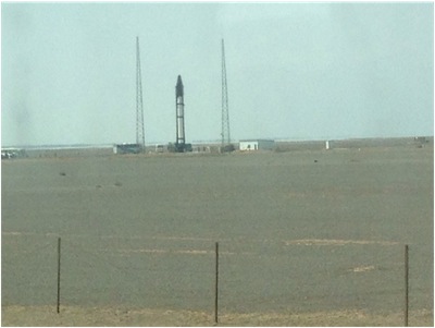 Figure 12. Image of the Kuaizhou launch taken from an access road near the launch site. (Source) |
To summarize, there is substantial evidence to support the conclusion that China is developing two different ASAT weapons systems derived from road-mobile ballistic missiles. The first system, designated SC-19 by US intelligence and possibly KT-409 by China, was tested five times as summarized in Table 1. The first three tests were likely conducted from the northwest pad at Xichang that was constructed sometime between April and November 2005. According to a classified 2010 State Department cable leaked by Wikileaks, the fourth test was conducted from the Korla Missile Test Complex. The third test in 2007 destroyed the FY-1C satellite while the fourth and fifth tests involved successful interception of ballistic targets launched by other ground-based missiles. The end of testing at Xichang could indicate that the RDT&E portion of development for this system is complete, although there is no direct, publicly available evidence supporting that hypothesis.
Table 1. Summary of tests in space of the SC-19 ASAT weapons system (source)
| Date of Test | Target Object | Interceptor Object | Interceptor Type | Amount of Trackable Debris Created | Notes |
|---|---|---|---|---|---|
| 7/5/2005 | None known | SC-19 | direct ascent | 0 | Likely rocket test |
| 2/6/2006 | None known | SC-19 | direct ascent | 0 | Likely flyby of an unknown orbital target |
| 1/11/2007 | FengYun 1C | SC-19 | direct ascent | 3,280 | Successful intercept and destruction of an orbital target |
| 1/11/2010 | CSS-X-11 (ballistic) | SC-19 | direct ascent | 0 | Successful intercept and destruction of a suborbital target |
| 1/27/2013 | Unknown (ballistic) | SC-19 | direct ascent | 0 | Successful intercept and destruction of a suborbital target |
| Total Amount of Trackable Debris: 3,280 | |||||
The preceding section presents circumstantial evidence to support the conclusion that a second ASAT weapon system was tested for the first time with the May 13, 2013, launch from Xichang. The exact rocket used in the test is unknown, but the most likely candidate is one launched from a TEL located on the new southeast pad at Xichang because there was no obvious SLV pad or rocket available at the time. It very unlikely any of the existing Chinese ballistic missiles could have reached the 10,000-kilometer altitude claimed by the Chinese government, let alone the 30,000-kilometer altitude claimed by the US government. However, the new Kuaizhou solid rocket SLV might be capable of doing so, and the photo from its launch in September 2013 shows that it, too, is launched from a TEL. On the issue of whether the May launch reached an apogee of 10,000 or 30,000 kilometers, if objects from the May launch re-entered the Earth’s atmosphere in the Indian Ocean anywhere south of the Indian subcontinent. That would be a clear indication that its apogee was much higher than 10,000 kilometers.
If the May launch was indeed the test of a new rocket for a new ASAT system designed to attack targets in deep space orbits, it is likely that there will be additional tests in the future as part of comprehensive testing program. Based on the testing program for the SC-19, future tests of the new system would likely involve more rocket flight tests and possibly future intercepts. If the new system utilizes the same kinetic kill vehicle (KKV) as the SC-19, actual intercepts may not be necessary since that KKV has been tested and demonstrated multiple times. However, if there is something different about the deep space engagement and intercept scenario compared to the LEO scenarios previous tested, the Chinese government might consider an actual destructive intercept in in or near GEO. That could be an extremely dangerous and damaging event for the space environment, as it could put at risk the hundreds of billions of dollars in both government and commercial assets by all nations in GEO. Preventing a destructive ASAT test in or near GEO by any state must be a goal of the entire space community.
| Satellites in GEO are the most vulnerable to a hit-to-kill direct ascent ASAT weapon system. |
Finally, the military utility of such a hit-to-kill direct-ascent ASAT system for attacking satellites in deep space orbits is not entirely clear. Satellite navigation systems in MEO such as the US military’s Global Positioning System (GPS) are not very vulnerable to such a system. The more than 30 GPS satellites currently in orbit are distributed across multiple orbital planes and widely spaced apart within each plane. A position fix requires receiving a signal from at least four satellites at once, and the constellation is designed so that many more than that are overhead most of the time. Thus, using a hit-to-kill direct ascent system to attack GPS would require many separate launches and successful intercepts over many hours to degrade GPS in any meaningful fashion.
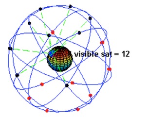 Figure 13. A notional 24-satellite GPS constellation and the number of satellites visible from a ground location at 45 degrees north latitude. Image from Wikimedia Commons (source) |
Satellites in HEO, such as the US military’s Space-Based Infrared System High (SBIRS) are somewhat more vulnerable to attack by direct ascent hit-to-kill systems but still fairly resilient. HEO orbits, also known as Molniya orbits after the Russian military communications satellites that first made use of them, have an apogee as high as 40,000 kilometers (25,000 miles) and a very low perigee of around 1,000 kilometers (600 miles). Thus they spend most of their 12-hour orbital period “hanging” over a portion of the Earth’s surface before whipping around perigee and coming back overhead. The ever-changing orbital velocity and altitude of satellites in HEO orbits complicates the targeting of a direct-ascent ASAT system, but the relatively few numbers of such satellites means one or two successful intercepts could knock out significant capability.
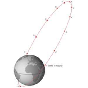 Figure 14. An example Molynia orbit, with the satellite's location in the orbit marked in hours from perigee. Image from Wikimedia Commons (source) |
Satellites in GEO such as the US military’s Advanced Extremely High Frequency (AEHF) communications satellites are the most vulnerable to a hit-to-kill direct ascent ASAT weapon system. They appear to hang over a fixed location on the Equator, making them always visible to the same ground location. The flight time of a direct ascent ASAT to GEO is measured in hours and the launch of such systems using conventional rockets is easily detected by US missile warning satellites. Given this lengthy flight time, it is much easier for a target satellite in GEO to detect the attack and possibly maneuver to avoid the intercept than a satellite in LEO that only has minutes to do so. Furthermore, an interceptor on a suborbital trajectory to GEO only has one chance to collide with the target. However, the increasing focus on high-efficiency ion engines over chemical engines for maneuvering capability of newer GEO satellites may leave them unable to change position fast enough to avoid an intercept. Combined with the concentration of capabilities in a small number of very large and expensive satellites, such systems are vulnerable to this type of attack.