Was GPS invented at “Lonely Halls”?by Richard Easton
|
| Parkinson, first head of the GPS Joint Program Office (JPO), and his JPO team played an important role in the early development of GPS. However, this does not mean we should accept uncritically his account. |
The two major rivals for the title of GPS’s inventor or chief architect are the Air Force’s Col. Parkinson and the NRL’s Roger Easton (my father), who started the important predecessor system called Timation, for Time Navigation, in 1964. Parkinson has asserted, “Roger [Easton] was not present at the ‘Lonely Halls’ meeting of 1973, when we decided what GPS was to be.”2 This leads to questions about what were the inspirations for the 1973 GPS synthesis, and how important Lonely Halls was in this process. If Easton’s system played an important role in the synthesis, his absence from Lonely Halls is irrelevant to assessing his contribution to GPS. Most important is recognizing that successfully implementing the 1973 GPS synthesis required close work and cooperation among the respective armed services.
There are problems with the Lonely Halls story. Milner quotes Ron Beard, second successor to Roger Easton as head of the Space Applications Branch (note that the name of this branch changed over time), who recently retired after 44 years of service at NRL and participated in the 1973 meetings, as asking why Parkinson and the JPO flew across the country to meet with themselves.3 The NRL’s story of an additional meeting that weekend might offer a reason for Parkinson and his team to travel cross-country. As recounted in my book, many NRL people claim that, in addition to the Lonely Halls meeting, Parkinson met with Easton and retired Navy Capt. David Holmes at a motel on Spring Hill Road that weekend. At that meeting, Parkinson said 621B was too expensive, and Holmes offered the Timation system in place of the just-rejected 621B.4 Ron Beard recently commented:
The reason for B[rad] P[arkinson] and his officers to travel to Washington was that is where the reviews of the material for the upcoming DSARC was taking place. They had a review scheduled for Currie about that time and that is where Currie told them the 621B approach was not going to fly. That is what brought them to Washington, not just to meet with Roger [Easton] and Dave [Holmes] as you imply. Nor was it to gain solitude as B[rad] P[arkinson] says in his versions of why the meeting occurred.5
There are other problems with Parkinson’s account besides the implausibility of a cross-country meeting for the JPO just to meet with themselves. Parkinson asserts that at Lonely Halls, the following decisions were made about GPS:
The fundamental 621B concept of simultaneous passive ranging to four satellites would be the underlying principle of the new system proposal, ensuring that user equipment would not require a synchronized atomic clock.
The signal structure would be the 621B CDMA modulation. It would include both a clear, acquisition modulation (C/A) and a precision military modulation (P/Y). The C/A modulation was to be freely available to civil users throughout the world.
There would be two GPS broadcast frequencies in the L band, using the same dual-frequency technique that Transit had employed to correct for ionospheric group delay, as well as providing redundancy.
Based on the progress that NRL had made in satellite clocks, the program committed to space-hardened atomic clocks on the first operational/demonstration GPS satellites (called Navigation Development Satellites, or NDS). At the Lonely Halls meeting, Parkinson concluded that the NRL technology was relatively low-risk, obviating the need to use the ground-relay, experimental demonstration scheme that 621B had previously proposed.
The orbits for the satellites were to be inclined at 62° and not geosynchronous. [JPO team member Air Force Major Gaylord] Green proposed 11-hour, 58-minute (sidereal synchronous) orbits that gave about two hours of testing over the same United States test area each day. NRL had advocated similar 8- or 12-hour inclined orbits. Because of the need for an extensive testing program on an instrumented range, exact 8- or 12-hour orbits would have been unsatisfactory, because they would continuously shift relative to the Earth. While these orbits resembled those advocated by NRL, Green’s modification was critical to the success of the testing program. 6
NRL’s Timation system, contrary to Parkinson’s repeated assertion over the years, also used simultaneous passive ranging to four satellites as is shown by the following drawing from the 1971 Timation Development Plan:
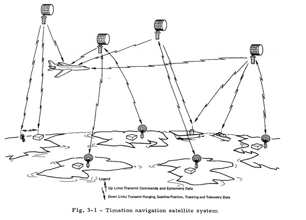 |
In this drawing, four Timation satellites are sending signals that are received by an airplane. The difference between when the signal was sent and its receipt gives the distance from the satellite. With four satellites in sight, the airplane’s three-dimensional position can be computed (the fourth satellite provides time synchronization.) Thus, Parkinson’s first point ignores the fact that both NRL’s Timation and the Air Force/Aerospace’s 621B had the concept of simultaneous passive ranging to four satellites.
| At least initially, the satellites would be repeater satellites, which means that they repeat the signal, including the time, sent from the ground station. Thus, knocking out or jamming the signal from the ground station knocks out the system. |
In discussing these issues, it is important to compare the important features of the two major pre-GPS satellite navigation proposals: Timation and 621B. Exhibit 1 summarizes these details. The Timation Development plan used 27 satellites in three evenly spaced planes (nine in each plane) in circular eight-hour orbits inclined at 55 degrees to provide worldwide three-dimensional fixes. Ground stations were in the US or in safely-controlled US possessions. They would update the satellite clocks and send them updates about their orbits. Both a spread spectrum signal and a side tone ranging signal would be used. Precise clocks would be in the satellites.7
621B used regional constellations consisting of one satellite in geosynchronous orbit and three or four highly inclined “eggbeater” satellites. Four such regional constellations could provide close to worldwide coverage. The ground stations needed to be in the same region as the constellation since the geosynchronous satellite remains roughly fixed over a point on the Equator. A spread spectrum signal would be used. At least initially, the satellites would be repeater satellites, which means that they repeat the signal, including the time, sent from the ground station.8 Thus, knocking out or jamming the signal from the ground station knocks out the system. Even an improved system with the clocks on the satellite is more vulnerable than Timation due to the dependence on ground stations in the same region.
Pete Wilhelm retired at the end of 2014 after a 55-year career at NRL. He built all four Timation satellites, the last two of which were renamed NTS-1 and NTS-2, and was director of the Naval Center for Space Technology. He recently commented:
The only satellite that flew both the STR [Side Tone Ranging – used by Timation]and PRN [Spread Spectrum – advocated for use by 621B, adopted in the Timation Development Plan and used today by GPS] was NTS-2 [launched in 1977]. NTS-1 [launched in 1974] only had STR even though I do believe we added another antenna for the possibility of adding another transmitter. I don't remember why we did that because there was no PRN system even close to being ready and there was no ground system to receive the signal anyway. Roger [Easton] understood this better than anyone! We needed to be able to test our concept to be sure it was accurate enough to do what needed to be done. STR was the only choice and it did answer the question of was the GPS system suitable. (i.e. On Board Clock and 12 hour, highly inclined, orbits). It clearly was!!!9
Thus, STR played a major role in validating the GPS approach even though it is not used today.
With this background, we can examine the development of GPS in 1973. On April 17, Deputy Secretary of Defense William P Clements Jr. ordered the formation of a JPO led by the Air Force. A 621B regional system would be launched with the satellites renamed NES (Navigation Experimental Satellites.) The Timation 3 satellite would be renamed NTS-1 (National Technology Satellite.) Thus, both the synchronous (621B) and sub-synchronous or mid-altitude (Timation) approaches would be tested.10 In June, a two-day meeting on the West Coast of all services resulted in a memo setting forth four alternatives, all of which included both NTS and NES satellites.11
| Perhaps Parkinson is reading back into Lonely Halls some decisions that were made later. |
In August, Parkinson proposed implementing 621B to the Department of Defense and was turned down. The Labor Day meetings followed. Can we evaluate the accuracy of Parkinson’s Lonely Halls claim today? Two post-Labor Day documents, plus a November 1973 Aviation Week & Space Technology article, shed light on this question. A September 21 addendum to a September 4 Development Concept Paper (DCP) gives two additional alternatives to the three it states were proposed in the September 4 document (which I don’t have.) The addendum explains, “Accurate clocks are required earlier in Alternative IV since the satellites are autonomous, processing satellites rather than the relay satellites of the first three alternatives.”12 With respect to the new alternatives, it notes, “A moderate increase in risk is associated with early selection of a specific DNSS [Defense Navigation Satellite System, soon renamed GPS] navigation signal structure for the processing satellites.”
Curiously, the three alternatives described in the September 4 document used relay (repeater) satellites. Parkinson claims they decided at Lonely Halls to not use “the ground-relay, experimental demonstration scheme that 621B had previously proposed.” Yet, the September 4 document that resulted from the Labor Day meetings had three alternatives using them. Since I don’t have the September 4 DCP, I cannot be certain whether it explains why these dead-end alternatives were still being considered, but it does appear to be inconsistent with Parkinson’s story about what was determined at Lonely Halls. Perhaps he is reading back into Lonely Halls some decisions that were made later.
Three alternatives were proposed in a document dated November 26, 1973. The first is not proceeding with GPS. The second is testing both synchronous (621B) and sub-synchronous (Timation) orbits. The third is proceeding only with the sub-synchronous satellites (Timation).13 As previously stated, Parkinson claimed the Lonely Halls meeting selected the sub-synchronous (mid-altitude) solution. His defenders could assert that other alternatives needed to be presented, since in the December 1973 meeting of the DSARC, both the Navy and the Air Force had to approve the system. An article with the same date says the Navy (Timation) orbits had been selected for GPS.14
An August article stated, “An Air Force spokesman expressed considerable admiration for the technical expertise of the Naval Research Laboratory team, headed by Roger Easton, that has carried out the Navy program. The spokesman said USAF hopes to take advantage of these NRL skills in the navsat program.”15 The following February, Air Force Lieutenant General Kenneth W. Schultz, Space and Missile Systems Organization (SAMSO) commander, sent a letter of commendation to Roger Easton and David Holmes stating:
A new baseline program, the NAVSTAR Global Positioning System, emerged as a coalescence of previous Navy and Air Force system concepts. This required a major effort to ensure the new program was technically sound. The Space Metrology Branch [Easton’s branch at NRL – also known as the Space Applications Branch] played a prominent role in assessing the technical problems associated with the new concept and providing feasible solutions to these problems.16
Pete Wilhelm recently commented:
I do remember seeing that letter from LTG. Schultz. Roger must have showed it to me. My recollection is by the time that letter was sent the basics of what did become GPS had essentially been decided. There were two over-riding issues: clocks on the ground vs clocks in orbit; equally important was the orbits: the AF 621B proposed 24 hour satellite orbits that stayed over a quadrant of the earth (but not high latitudes-like the North Pole region - prime Navy interest). It became known as the "egg-beater orbits". It would have been very expensive requiring at least 16 very large, expensive, launch vehicles. I think this, as much as anything, is why they told B[rad] P[arkinson] that 621B was not affordable. We had proposed highly inclined orbits, at medium altitudes, that could be launched on much lower cost launch vehicles and that covered the entire globe - thus a "GLOBAL POSITIONING SYSTEM"! The final issue that Schultz is talking about is the waveform to be used: STR or CDMA? The decision at the time was a good compromise: just fly both on the same satellite. This turned out to be a very good idea for a couple of reasons. The A[ir] F[orce] CDMA concept required a[n] undeveloped set of complex hardware. The hardware failed early after the launch of NTS 2. The fact that we had an alternative path, via the STR, allowed us to evaluate the atomic clock and the viability of "PASSIVE RANGING" from this medium altitude orbit. This was a big deal.17
Thus, the initial formulation was GPS was not determined solely by Air Force officers in the nascent GPS JPO, but rather from interaction between the JPO and other parties, such as the NRL Timation veterans and higher authorities from the three branches of the armed services. Admittedly, Parkinson and the other members of the JPO played an important role, but all three services needed to be convinced to proceed with the system in the DSARC. The synthesis stemmed more from Timation, particularly from the Timation Development Plan,18 than from any other predecessors to GPS. If anyone has a copy of the 9/4/1973 DCP, please contact me at www.gpsdeclassified.com (original documents, including the Timation Development Plan, are posted there.) It doubtless would shed more light on the important decisions made in 1973.
Endnotes
- Greg Milner, Pinpoint: How GPS is Changing Technology, Culture, and our Minds, (New York: W.W. Norton, 2016), 54
- Bradford Parkinson, Inside GNSS, May 2010.
- Milner, 57.
- Richard D. Easton and Eric F. Frazier, GPS Declassified, From Smart Bombs to Smartphones, (Lincoln, NE: Potomac Books, 2013), 67.
- Ron Beard, email to Richard Easton et al., September 4, 2016.
- Bradford W. Parkinson and Stephen T. Powers, “The Origins of GPS and the Pioneers Who Launched the System,” GPS World, May, 2010.
- Naval Research Laboratory Report 7227 - Timation Development Plan, March 2, 1971.
- J. B. Woodford and H. Nakamura, “Briefing- Navigation Satellite Study”, 24 August, 1966.
- Pete Wilhelm, email to Richard Easton et al., September 27, 2016.
- Dept Secretary of Defense William P. Clements, Jr., April 17, 1973 memo.
- Decision Coordinating Paper (DCP) 121 dated June 7, 1973.
- Addendum to Development Concept Paper (4 September 1973) Defense Navigation Satellite Development Program, 21 September 1973.
- Development Concept Paper Number 133, NAVSTAR Global Positioning System, 26 November 1973.
- Phil Klass, “Compromise Reached on Navsat”, Aviation Week & Space Technology, November 26, 1973.
- Phil Klass, “Plans for Defense Navsat Readied”, Aviation Week & Space Technology, August 20, 1973.
- Dated 28 February, 1974.
- Pete Wilhelm, email to Richard Easton et al., September 26, 2016.
- Timation Development Plan.