Dark clouds: The secret meteorological satellite program (part 2)The Radio Corporation of America and the Army’s reconnaissance satelliteby Dwayne Day
|
| “I remember sitting in a meeting with von Braun in the old Franklin Hotel in Philly when the reconnaissance satellite problem came up,” Staton wrote, “And von Braun said, ‘let’s look at clouds!’” |
In contrast, Lockheed impressed everyone. The company sent its top executives, who personally expressed their commitment to making the satellite work. They also proposed using film instead of a television camera in their satellite. The film would be developed onboard the spacecraft and then scanned, and the images transmitted to Earth. Lockheed got the overall contract. But although RCA executives were unhappy about losing, they certainly did not give up. They thought they had a good satellite proposal and if the US Air Force was unwilling to fund it, RCA would find someone else who would. As Amrom Katz joked at the time, their work “left RCA with a bag full of studies to exploit elsewhere.”
RCA submitted a modified version of their satellite proposal to the Weather Bureau in the Department of Commerce, arguing that essentially the same vehicle RCA had proposed for reconnaissance could be used to photograph clouds. But the Weather Bureau was not interested. In 1957 RCA took its reconnaissance satellite proposal to the Army’s Redstone Arsenal at Huntsville, Alabama, which was developing long-range missiles. The rocket team’s leader, Wernher von Braun, liked the satellite idea and gave RCA a contract to further study the subject. He wanted RCA to evaluate a small reconnaissance satellite for the Jupiter rocket. Von Braun soon gave the company a second contract to design a satellite structure, power supply, stabilization system, environmental control, orbital dynamics, and electronic instrumentation, as well as the necessary ground station equipment.
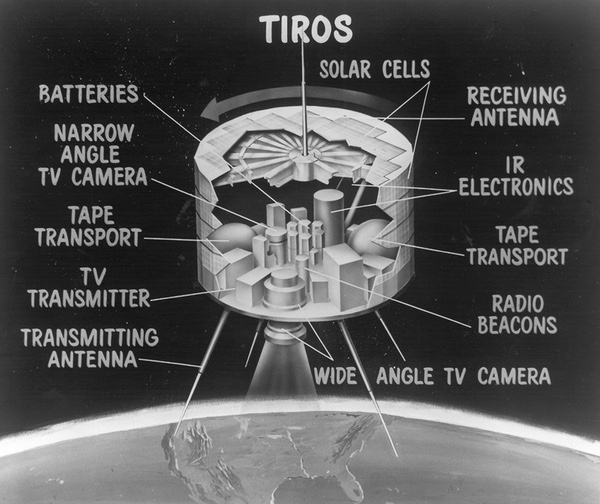
 Tiros weather satellite in the collection of the National Air and Space Museum. Tiros had wide angle and narrow angle cameras looking out the bottom of the spin-stabilized spacecraft. (credit: Eric Long, NASM) |
Maurice Staton, who was then RCA Sales Manager, remembered how he soon became involved in the program. “A group at RCA David Sarnoff Lab was already at work on a reconsat for von Braun,” he wrote more than 40 years later.[2] “When Astro was formed, seven of us from Camden Industrial Products were sent up to the Princeton Labs to start the Astro Electronics Division. We were quartered in a small lab in a secure area just east of the David Sarnoff Laboratory in Hightstown, near Princeton, New Jersey.”[3]
But in late 1957 or early 1958, the Army was told by the Department of Defense not to develop a reconnaissance satellite because it was already an Air Force job. Staton and several of his colleagues met with von Braun in Philadelphia. “I remember sitting in a meeting with von Braun in the old Franklin Hotel in Philly when the reconnaissance satellite problem came up,” Staton wrote, “And von Braun said, ‘let’s look at clouds!’”[4] The RCA engineers soon redirected their efforts from reconnaissance to weather observations. The satellite design that they developed was called Janus. It was a rod-shaped payload that weighed about 20 pounds (9 kilograms) with a diameter of five inches (13 centimeters). This was a bad shape and weight to carry all the equipment for a weather observation satellite, but anything bigger or different would not fit the Jupiter booster.[5] It soon became clear to Staton and others that even if they could design a satellite within these constraints they faced many other problems.
Although the satellite was supposed to be spin-stabilized, its relatively small diameter meant that it would tumble while in orbit. Explorer I, which was launched on January 31, 1958, had the same configuration and it had tumbled. Another obstacle was that the satellite was spun up to more than 500 rpm during launch, but then had to be de-spun to 7–12 rpm for optimum camera performance. This would be difficult to accomplish.
Staton and his team began to look at other configurations for Janus. One option was a ball-shaped satellite. But RCA engineers considered a disk-shape to be the best design and the availability of the new Juno II booster allowed designers to increase both the satellite’s size and weight, which made designing it much easier.
| The White House had ordered that the meteorological satellite program be transferred from military control (under ARPA) to NASA because they viewed meteorological research as primarily a civilian job. |
With its larger diameter, the satellite did not need to spin as fast to attain orbit and it was easier to slow its rotation rate once it had achieved orbit. Staton remembered that they used a set of “yo-yo” despin weights. These were metal weights deployed on the ends of wires. When a spinning ice skater stretches out her arms, she slows down. The metal weights did the same thing for the satellite. When they were fully deployed, the satellite would slow its spinning and the weights would be jettisoned, taking their energy with them. The engineers tested the system in their lab. “The setup for testing the throw-out weights to reduce the spin rate was pretty crude,” Staton remembered. “We had work benches set up on their sides and they were well dented from being hit by the weights being flung off.” Other parts of the satellite were also tested there. “The camera sensor portion of the program was old hat because RCA had been building half-inch vidcon cameras,” Staton said, “and the main problems were ruggedization, thermal control and power.” All of these problems could be solved.[6]
In April 1958, the Advanced Research Projects Agency (ARPA), a Defense Department agency that had just been created to direct all military space programs, ordered the US Army Ordnance Missile Command to proceed with development of its experimental weather satellite. The following month an Ad Hoc Committee on Meteorology was created by ARPA to develop the design objectives for the satellite. This committee eventually renamed the satellite Tiros. Tiros remained an ARPA responsibility under Army development even after NASA was created in October 1958.
In April 1959, Tiros was transferred to NASA, although the Department of Defense maintained input into the design. RCA continued to develop Tiros under the authority of von Braun, who was now at NASA, and Homer Newell, who was NASA’s deputy director for spaceflight programs. Its first launch was planned for early 1960, atop a Thor booster. The White House had ordered that the meteorological satellite program be transferred from military control (under ARPA) to NASA because they viewed meteorological research as primarily a civilian job, and the civilian Weather Bureau’s interest in the advantages of a meteorological satellite were a major factor in this decision. At the time, no military sponsor demonstrated a clear interest in funding the program.
Civilian control of the Tiros program had other advantages as well. In September 1959 NASA Administrator T. Keith Glennan proposed to the White House that meteorology was a potential area of cooperation between the United States and the Soviet Union. He called this proposal Project Comet.[7] Glennan made a more definitive proposal to President Eisenhower in April 1960, after the successful launch of Tiros I. Glennan’s proposal was for the United States and the Soviet Union to each launch a meteorological satellite and to share the data.[8] Two days later, Glennan discussed the idea with President Eisenhower. Eisenhower was concerned that the Soviets could use the failure of an American satellite to embarrass the United States, but he was still willing to make the proposal to the Soviets. Everything hinged on Premier Khrushchev’s behavior at the upcoming summit: if Khrushchev maintained the hard line that he had assumed at an earlier speech at Baku, Eisenhower would not make the proposal. But if the Soviet Premier seemed conciliatory, Eisenhower would propose the cooperative program.[9]
But Eisenhower never got the chance. Three days later Gary Powers was shot down over the Soviet Union. Khrushchev was outraged, the summit was called off, and superpower relations became stormy. The cooperative meteorological satellite program was dead for the foreseeable future.
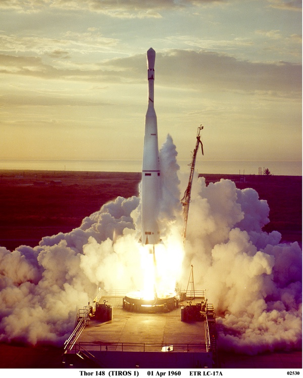 Launch of the first Tiros weather satellite. Tiros proved successful and increased interest in the U.S. Air Force in developing a military weather satellite. But Tiros flew in an orbit that did not pass over important targets, like Moscow. Any military weather satellite would have to fly in an orbit similar to the reconnaissance satellites it supported. (credit: Peter Hunter Collection) |
NASA launched the first Tiros satellite aboard a Thor-Able rocket on April 1, 1960. The satellite was an 18-sided polyhedron shaped like a hatbox measuring 22.5 inches high and 42 inches in diameter (0.6 by 1.1 meters) and weighing approximately 270 pounds (123 kilograms). The satellite spun with its bottom facing the Earth. Sticking out of the bottom were two television cameras, which took pictures as they passed over the Earth and relayed them to the ground.[10]
Verner Suomi, a civilian scientist who soon became involved in the program, recalled that there was a frustrating problem with the data that Tiros returned. “We didn’t know what the devil the damned thing was looking at,” Suomi said. “There were some problems as to what time the pictures were taken, and the spacecraft was spinning like a top. Where the devil was north? That caused major problems.”[11]
| By the time that Tiros flew the agency had decided to develop a more ambitious follow-on to Tiros which would abandon spin-stabilization entirely. |
Compounding the challenge of locating what the satellite was photographing was an additional problem: Tiros was not simply spinning, but wobbling. This meant that even if operators knew which direction was north in the photos Tiros beamed back to earth, the camera might be tilted at different angles each time it passed it. It might be facing down at one pass and tilted forward at another, imaging an area far away from the satellite’s location or right below it.
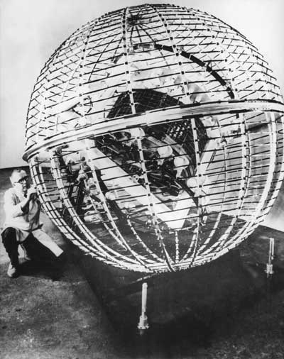 Tiros was spin-stabilized and its two cameras looked out of the bottom of the spacecraft. Due to the Earth's magnetic field, the satellite wobbled in orbit, meaning its cameras were not always looking straight down. Engineers built a special magnetic cage and put the satellite inside to assess the problem. (credit: NASA) |
Maury Staton remembered how they evaluated the wobbling problem: “Engineering built a cage about ten feet in diameter, big enough to rotate the satellite in.” The cage was a ball of coils which allowed the engineers to measure the spacecraft’s magnetic field. What they discovered was that the spacecraft had a magnetic field that was interacting with the Earth’s magnetic field and causing the spinning spacecraft to wobble. They proposed a solution that solved the problem by adding a magnetic coil to the spacecraft. “And it not only corrected the problem,” Staton remembered, “it turned into a magnetic torqueing system to adjust yaw and pitch.”[12] Thus, without adding any moving parts or rockets to the satellite, they could control its attitude. But according to Staton, NASA was not interested in this clever fix. For NASA officials the Tiros design was merely experimental, not operational. By the time that Tiros flew the agency had decided to develop a more ambitious follow-on to Tiros which would abandon spin-stabilization entirely. The agency official in charge of Tiros was willing to fix some of the easier problem but did not want to make any major changes to what he considered an obsolete design.
Despite the initial problems, Tiros worked well and impressed many within the government, particularly the Air Force. Some Air Force officials who had previously ignored weather satellites suddenly realized that it could be important for their mission. But it was not simply Tiros’ success that renewed Air Force interest in weather satellites, it was also the success of satellite reconnaissance. [13]
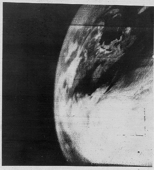 The first Tiros image of the Earth, taken in April 1960. Tiros was developed and launched by NASA. It was initially difficult to identify direction in the photographs. (credit: NASA) |
President Eisenhower had formally approved the CORONA reconnaissance satellite program in February 1958. The CIA quickly developed a cover story that it was merely an engineering program to develop technologies for future use.
The first CORONA test launch had occurred in early 1959 and the first launch of an actual camera took place in June. But CORONA suffered a series of failures through the summer of 1960. In July 1960, a CIA official visited the Advanced Projects facility in California where CORONA spacecraft were assembled. The official wrote his superiors: “I was informed that they either now have or will have shortly a control capability which will permit deletion of a photographic pass. It was explained to me that, by means of a minor modification to the circuitry, command controls could be given which would block pre-programed signals from reaching the camera for a selected orbit.” He continued: “It seems that the most logical use of this new command capability would be that of saving film by elimination of a photographic pass when current weather information indicates poor photographic indications over prime target areas.”[14]
The official then suggested that Tiros data could be highly useful if it was provided directly to the CORONA control facility. If Tiros detected clouds over a target that was due to be photographed by a CORONA satellite, they could quickly command the CORONA to not take the photograph and thereby save the film for another target.[15] This was not the first time that CORONA and Tiros had crossed paths. A year earlier intelligence officials debated whether or not Tiros photographs would reveal American reconnaissance satellite capabilities and should therefore be classified. Richard Bissell, who then ran the CORONA program for the CIA, determined that Tiros photographs should not be classified and posed no threat to CORONA.[16]
In August 1960, CORONA achieved its first successful mission, returning thousands of useful photographs of the Soviet Union. But many of the targets were obscured by clouds, which only emphasized the need to obtain reliable cloud information prior to a reconnaissance pass over a target.
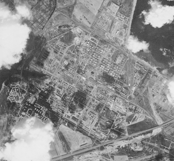 A Moscow oil refinery partially obscured by clouds. Some parts of the Soviet Union were cloud-covered for many months of the year. During the 1960s, American reconnaissance satellites had limited amounts of film, and used data from weather satellites to avoid wasting film photographing cloud-covered targets. (credit: USGS) |
On August 25, 1960, a high-level advisory panel reported to President Dwight Eisenhower and his National Security Council about the need for reforms to the Air Force’s reconnaissance satellite program. This panel had wide-ranging impact. It led to the eventual cancellation of the Samos filmreadout satellite program and the creation of two new film-return satellite programs. One of these was the Samos E-6, which was essentially designed to replace the CORONA with a satellite with higher resolution capable of searching the Soviet Union looking for ICBM sites. (See: “A phoenix dying in Samos ashes: The SPARTAN reconnaissance satellite program,” The Space Review, January 24, 2022.) The other was the covert GAMBIT high-resolution satellite to conduct “evaluation of the operational status of a missile site.” [17]
| If Tiros detected clouds over a target that was due to be photographed by a CORONA satellite, they could quickly command the CORONA to not take the photograph and thereby save the film for another target. |
The panel also called for close integration of the reconnaissance satellite program with “the weather services that will be associated with the Tiros project” and other sources of weather data. But they provided no guidance on how this was to be accomplished.[18] In September, Richard Bissell visited NASA Deputy Administrator Hugh Dryden to discuss the use of Tiros data for CORONA operations.
There was a major limitation to Tiros, however. Tiros 1 had been launched into a 48.4 degree orbit, meaning that it only reached 48.4 degrees north and south of the Equator. Moscow was at 55 degrees 45 minutes north, and Tiros would get nowhere near it or many of the other targets that American intelligence officials wanted to photograph in the Soviet Union. Clearly something better was required.
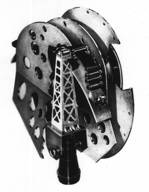 The CORONA reconnaissance satellite carried a film-based camera. The first successful mission was in summer 1960, and photo-interpreters soon discovered that up to 50% of the targets were covered by clouds. Engineers soon added a feature allowing ground controllers to keep the camera off if the target was cloud-covered, but that required information from a weather satellite about the clouds over the Soviet Union. (credit: NRO) |
As Tiros progressed but before it had actually flown, Lockheed, the prime contractor for several major Air Force satellite programs, pitched a “Satellite Weather System” to Air Force space officials. Lockheed first proposed this system in August 1958. The only surviving evidence for this proposal is a single color briefing slide, and there is no evidence the Air Force seriously considered starting a weather satellite at this time. Lockheed proposed using the Agena upper stage, then known as the Hustler, to point toward the earth with a camera system mounted at its nose. Lockheed claimed that such a satellite could be used for military missions, scientific research, storm observation, and domestic weather forecasting. [19] In January 1959 Lockheed proposed a more ambitious “Weather Surveillance” system. This too would use the Agena upper stage, but would include a camera, a radiometer, and radar to provide a synoptic record of cloud type, cover, velocity, albedo, and terrestrial radiation spectrum and heat balance. This sophisticated satellite was also not approved. [20]
In late 1958 and into early 1959, Tiros was an Army satellite program, but was in the process of being transferred to the new civilian space agency. There was no way that the Air Force could start a new military weather satellite at the same time that another military weather satellite was being transferred to civilian control. The Eisenhower administration was wary of competing military projects, and there was no reason to operate both civilian and military weather satellites. Furthermore, Congress would have asked hard questions about the need for duplicative military and civilian programs.[21]
| Power then concluded: “I am convinced that we need an operational satellite as soon as possible and that we, in the USAF, are the ones who should be given responsibility for its operation.” |
On December 1, 1960, General Thomas Power, Commander of Strategic Air Command, wrote Air Force Chief of Staff General Thomas White about the need for an Air Force weather satellite. Power stated that with the U-2 no longer conducting overflights of the Soviet Union due to the Gary Powers shootdown, the United States would have to rely on its planned reconnaissance satellites more than ever. President Eisenhower had approved two new reconnaissance satellite projects in August, the Samos E-6 that was supposed to eventually replace CORONA and the KH-7 GAMBIT. “Since Samos will be dependent on cloud conditions to insure that the selective take capability of the system is efficiently used,” General Power wrote, “it appears only reasonable for Russia to deny the free world weather data from the Sino-Soviet bloc.” He continued: “This action would not only have an immediate and serious effect on our ability to provide weather forecasts for the operation of Samos, but would provide Russia with a tremendous propaganda drum, for all nations are interdependent upon one another in their endeavor to understand and predict the actions of the atmosphere.”[22]
Power stated that the loss of this weather data would also “adversely affect the quality of the wind information needed for employment of the Strategic Air Command and seriously degrade the wind and cloud information needed for those aircraft committed to the nuclear war fighting plan which were restricted to visual flight rules.”[23] Fighter aircraft assigned to carry nuclear weapons in time of war could only fly in relatively good weather. “We must therefore,” he wrote, “develop alternative methods to acquire needed data.” One solution was “an operational weather satellite system under Air Force control.” NASA’s Tiros I satellite showed that this was possible. Power stated that, on October 17, NASA had also indicated that weather satellites were “almost ready to be considered operational,” and that either the Weather Bureau or the Department of Defense should take control of them, since NASA was a research and development agency and not an operational agency.[24] Power then concluded: “I am convinced that we need an operational satellite as soon as possible and that we, in the USAF, are the ones who should be given responsibility for its operation. As you know, the US Weather Bureau, being under the Department of Commerce, is in a very poor position to obtain funds to support the system and I am sure would not have the same interest in the program as we will have. We should now press for control of the meteorological satellite system if we are to insure that the output from the system will satisfy our requirements.”[25]
The RCA engineers who built Tiros for NASA were having the same thoughts. RCA was also building the complex SAINT satellite interceptor for the Air Force. The Sarnoff Lab was working on SAINT’S sensor, including its television cameras, electronics, and the radar, which was supplied by Westinghouse. The Burlington, Massachusetts, division of RCA was building the SAINT’s structure.[26]
But the overall relationship between RCA and the Air Force was not very good. Maury Staton was by now the Product Manager of RCA’s satellite program, which was then building a second batch of Tiros satellites for NASA. Staton remembered that he and the program’s chief engineer, Sid Sternberg, were constantly arguing over the technology they had proposed in their losing bid for the Air Force’s reconnaissance satellite in 1956 and had continued to study under some small Air Force research contracts. Sternberg thought that a television-based reconnaissance system was still feasible and felt that RCA should continue to press the Air Force to adopt one. But Staton thought that film was the better technology for reconnaissance and that RCA should instead propose a film-based system to the Air Force.
| The proposed satellite occupied an odd niche in the Air Force’s growing stable of space launchers: it was too light to warrant use of the proven Thor-Agena, and too heavy for any of the other rockets. |
Staton’s job was to maintain contacts with NASA. But he still had contacts with ARPA, the military agency that had directed the Tiros program before NASA took it over. In fall 1960 an Air Force colonel whom Staton had worked with at ARPA said to him, “Maury, why don’t you fellows stop fighting the Air Force and do something to help them?” So Staton went to RCA’s leadership and suggested that the company propose building a weather satellite like Tiros for the Air Force. Astro Division’s manager, Barton Kreuzer, told Staton to go back to ARPA and get permission to approach the Air Force. The colonel at ARPA gave the company his blessing and Staton and an engineer soon headed out to the Air Force Ballistic Missile Division (BMD) in Los Angeles to meet with Lieutenant Colonel Dick Stine. The meeting went well and Stine told them to write up a formal proposal for a weather satellite system for the Air Force.[27]
On November 17, 1960, RCA formally proposed a cloud cover satellite system to the Air Force.[28] The submission went to Colonel Harry Evans, Assistant Deputy Director for Space Programs in BMD. Evans was deputy to Major General Robert Greer, who was then responsible for the Air Force’s reconnaissance satellite program. Greer commanded what was known as the Samos Program Office at BMD. RCA proposed a 300-pound (136-kilogram) satellite—slightly heavier than Tiros—two readout stations, satellite control center, and management of cloud cover analysis services. [29]. RCA’s proposal involved extensive “off- the-shelf” system elements borrowed from Tiros. This was particularly attractive to both Herbert York, the Director of Defense Research and Engineering (DDR&E), the Pentagon civilian responsible for overseeing all new advanced military programs, and Joseph V. Charyk, Undersecretary of the Air Force, the civilian Air Force official in charge of space programs.[30] Both men soon became interested in the idea of an Air Force weather satellite.
Colonel Evans studied the RCA proposal for two months and considered how the Air Force might overcome obvious obstacles to its approval.[31] The chief technical difficulty was selecting an economical launch vehicle. The proposed satellite occupied an odd niche in the Air Force’s growing stable of space launchers: it was too light to warrant use of the proven Thor-Agena, and too heavy for any of the other rockets. Evans considered flying it as a secondary payload on a Thor-Agena during CORONA reconnaissance satellite flights. There was a logic to this, because the weather satellite would be used to support CORONA operations. But Evans quickly abandoned the idea because the reconnaissance satellite already used up all of the rocket’s available lifting capability.
The Air Force’s Air Weather Service (AWS) was also asked to review and comment on the RCA proposal. AWS leaders were not enthusiastic. They wanted a satellite that could provide information on night clouds as well as daytime weather. They also wanted a satellite that could operate in poor light and that would be more automated. In short, the Weather Service wanted a highly-sophisticated system, with a complex communications net for disseminating the data. The RCA proposal was simply too primitive by their standards. But some Air Force officials thought that AWS was being hypocritical; two months earlier AWS had proposed a system only slightly more sophisticated than the one proposed by RCA, only to have their proposal rejected. Now they were insisting upon a much more complex satellite.[32]
In February 1961, Colonel Evans suggested to Lieutenant Colonel Stine, the head of BMD’s Scout booster office, that it might be feasible to develop a variant of RCA’s proposed satellite for launch aboard the Scout.[33] At the time the Air Force was considering acquiring the NASA-developed Scout rocket for small satellite payloads. But the “Blue Scout,” as it was called, as yet had no payloads.
By early March, Colonel Stine had reviewed the idea of a Scout launch in considerable detail and sent an enthusiastic report to Evans. He felt that the satellite could be redesigned to dramatically reduce its size to only 100 pounds (45 kilograms) and fit aboard the Scout. Stine and his program office put together and submitted a preliminary development plan and Evans endorsed it.[34]
By this time, the military weather satellite program, which had finally gathered steam after a decade and a half of discussion, was about to dramatically change direction.
Note: we are using a new commenting system, which may require you to create a new account.