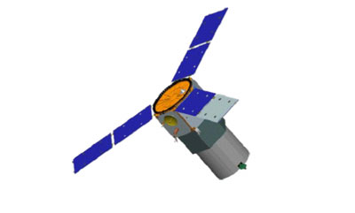
TacSat-3: a potential revolution in space-based operational intelligence gatheringby Taylor Dinerman
|
| This type of imagery could, if properly used, lead to a revolution in intelligence comparable to the one accomplished by the codebreakers of World War 2. |
While multispectral imagery has long been in use, it’s been less than a decade since the first (unclassified) hyperspectral imager, called Hyperion, was launched in November 2000 on NASA’s EO-1 satellite. This spacecraft is still operational and will be through at least this September. Hyperion works in 220 spectral bands and has a 30-meter resolution, pretty good for a low-cost technology demonstration project designed 10 years ago.
EO-1 has been providing useful data that requires a sophisticated combination of hardware, software, and trained personnel in order to extract useful information that can be enhanced and used to detect any changes that have occurred between two or more dates. This is a time-consuming process that does not fit the needs of a warfighter for quick and easily accessible information.
The goals of the ORS project were described in a February 2007 briefing as being “Four ideas with the same name.” The first idea is the best known, to give the combatant commanders direct access to, and tasking authority over, a set of space assets. The second goal is to change the economics of military space and to get away from the extremely expensive—though highly capable—intelligence satellites and replace them with smaller specialized spacecraft, such as TacSat-3. The third element is the drive to reduce the costs of getting spacecraft into orbit. This is why the ORS program has been so supportive of Elon Musk’s SpaceX and their Falcon launchers, although they also are using Orbital Sciences Corporation’s Minotaur that recycles old elements of Minuteman ICBMs. The fourth and final idea is to push forward new technologies that will allow the Defense Department to “surge and replenish” satellite constellations and to do so quickly and at a reasonable cost.
Turning a demonstration project into usable and effective intelligence gathering tool is a very difficult process and one that the ORS office may not be able to handle, at least not by itself. The need will not simply be for a set of satellites and associated ground equipment but for a new kind of database and groups of highly-trained specialists to interpret and disseminate the resulting information.
So far the US military has pioneered the use of Measurement and Signature Intelligence (MASINT) but has not yet fully reaped the benefits of this technology. As a recent Congressional staff study explained, “Masint is both a true, unique collection/analysis discipline and a highly refined analytical technique of the traditional disciplines.” These include such well-understood areas as Imagery Intelligence (IMINT) and Signals Intelligence (SIGINT). “MASINT is the least understood of the disciplines and is perceived as a ‘strategic’ capability with ‘tactical’ support capabilities,” the study concluded. It thus fits nicely into the “operational” aspect of the ORS project.
MASINT depends on huge computerized catalogs of information that are supposed to be able to tell interpreters what any given item looks like against or under any given background. For example, a tank hidden under a net in a forest will give off certain signatures, such as the way the soil or vegetation is disturbed or the way the heat or magnetic signature of a large chunk of metal interacts with the nearby ecosystem. Ideally, for such a system to be effective, geologists, biologists, botanists, physicists, as well as experts in spectroscopy and tank warfare must all be brought together in real time to analyze the incoming data. Obviously no tactical commander will be able to have such a collection of experts on call twenty-four hours a day.
Automating major parts of the interpretation and analysis function is going to be required, but it is also by far the most difficult part of transitioning from an experimental system to an operational one. There have been a number of recent claims that target recognition software has made major strides since the early part of this decade. Previously, during the Kosovo air campaign of 1999, the Serbs were able to conduct effective denial and deception operations that prevented the US from successfully hitting their ground forces deployed in Kosovo. In 2003 in Iraq, the US was able to target Saddam’s armored forces even in the middle of a sandstorm. It is still an open question, though, whether US technology had improved or whether the desert environment was more favorable for the available sensors.
| Automating major parts of the interpretation and analysis function is going to be required, but it is also by far the most difficult part of transitioning from an experimental system to an operational one. |
Each of America’s regional commanders will need a unique database and a team of professionals to go along with it. It could be that some future ORS satellites could be tweaked to conform to regional requirements. This will only be possible if the size, weight, and cost of these sensors can be kept low. If the so-called “plug-and-play” architecture that they hope to fully develop works out, then such individualized spacecraft could be deployed in large enough numbers to provide operationally significant coverage.
Sometime next year, after TacSat-3 has been launched and the ORS people have gained some experience with it, the Pentagon will have to consider what it wants to do next. Will it decide to just build yet another technology demonstration project or will they decide to go for a constellation small satellites equipped with hyperspectral imagers, as well as an extensive interpretation and analysis system? Whatever the decision the role of the Central MASINT Organization should be at the heart of any future ORS developments.
