How has traffic been managed in the sky, on waterways, and on the road? Comparisons for space situational awareness (part 1)by Stephen Garber and Marissa Herron
|

| While there has been considerable discussion of SSA and STM in recent years, it is worthwhile to clarify why these subjects are especially important now. |
To begin, we should define STM and SSA. These terms are often used somewhat interchangeably and there is little consensus about their precise meanings. One recent report, for example, devoted a four-page appendix to detailing how various organizations define SSA and STM.[2] For the purposes of this article, we will use SSA to refer to operational practices to understand the space environment by identifying the orbits of spacecraft and debris, as well as to observe and predict space weather and activities by other spacecraft. STM will refer to broader activities such as oversight, policy, coordination among space actors, and standards for SSA. In the fall of 2019, the Air Force moved to replace SSA with a new term, Space Domain Awareness, but for our purposes, this is a semantic change.[3] One expert proposes the use of the term Space Traffic Coordination (STC) instead of STM.[4]
While there has been considerable discussion of SSA and STM in recent years, it is worthwhile to clarify why these subjects are especially important now. Concerns about orbital debris extend back to the early years of the space age and in particular the 1970s, when NASA scientist Donald Kessler foresaw a potential domino effect of debris. Then two events about a decade ago created significant increases in debris fragments in Low Earth Orbit (LEO): the Chinese government deliberately destroyed one of its own satellites in 2007, followed in 2009 by an accidental collision between an Iridium and a Cosmos satellite.[5] In March 2019, India also conducted an ASAT test that created 6,500 small pieces of debris and only about 125 pieces large enough to be catalogued; this wasn’t discussed widely in the trade press, perhaps because the Indians claimed most of the fragments would burn up on reentry of the Earth’s atmosphere.[6] Additionally, only a small percentage of debris in LEO and geosynchronous orbit (GEO) is currently tracked because of their size, but this percentage is expected to grow considerably now that the new Space Fence is operational.[7]
Another reason this subject is very topical now is because various domestic and international companies have proposed, or are launching, “megaconstellations” of communications satellites.[8] If companies such as SpaceX, Amazon, or Samsung launch even half of their proposed fleets of thousands of small spacecraft, the number of objects in LEO could increase exponentially, causing serious concerns about debris, SSA, and STM.
There is also the issue of the Tansat spacecraft, which was launched by China’s Ministry of Science and Technology in December 2016. This satellite was designed to utilize a highly desirable scientific orbit occupied by NASA’s “A-train” set of Earth-observing satellites such as NASA’s Orbiting Carbon Observatory 2, which launched two years earlier. Unfortunately, Chinese officials did not coordinate internationally until rather late in the launch planning process, but thankfully they were ultimately able to loft it into a different orbit. While this was more of a mission design constraint than an STM issue per se, the lack of initial coordination concerned some observers, as it could have been a prelude to future such situations.[9]
In March 2018, Swarm Technologies made the trade press in an unfortunate way after it deliberately launched four very small satellites aboard an Indian rocket without prior authorization from the Federal Communications Commission (FCC), causing the FCC to withhold permission for lofting more Swarm microsatellites the next month.[10] While Swarm had equipped the four experimental microsatellites with special GPS transmitters and Ku-band radar reflectors to enable tracking of the tiny SpaceBee spacecraft, the “FCC was concerned that these aids were unproven and insufficient, as the SSN [Space Surveillance Network] currently does not have any tracking radars operating in Ku-band.”[11] Yet a commercial SSA vendor, LeoLabs, and potentially even the Air Force were able to track the SpaceBees.[12]
| The Starlink/Aeolus close approach clearly indicated the need for better, earlier, and/or automated communications among space operators. |
Nevertheless, one author commented that this situation demonstrates “why it’s past time to move beyond relying on the legacy SSA capabilities of the US military.”[13] In addition, some would argue that the military should focus on its own spacecraft tracking needs, rather than also having to monitor commercial spacecraft, especially those that are very small and maneuvering often, making them doubly difficult to track. Perhaps more important than the technological detection issue is the need to have consistent FCC regulations that are not overly burdensome for industry (apparently the FCC initially granted and then revoked Swarm’s license before launch) so everybody knows what to expect.
In September 2019, a SpaceX Starlink satellite ran a significant risk of colliding with a European Space Agency (ESA) satellite until ESA maneuvered its Aeolus spacecraft out of the way. Although initial communications occurred between the two operators, the SpaceX operator was unaware when the close approach later returned as an issue. SpaceX blamed the problem on a bug in their internal paging system, and both ESA and SpaceX officials discussed the need for automated collision avoidance. One specialist noted, “No one was at fault here, but this example does show the urgent need for proper space traffic management, with clear communication protocols and more automation. This is how air traffic control has worked for many decades.”[14] Another expert noted, “If you have to deal with one or two close approaches a month, picking up the phone might be fine. But if you now have to deal with dozens or hundreds, it’s not going to scale.”[15] Close approaches between two operational satellites are rarer than approaches involving two pieces of debris or an operational satellite and a debris fragment. This incident clearly indicated the need for better, earlier, and/or automated communications among space operators.
Later that month, two large defunct spacecraft, Cosmos 1300 and Bigelow Genesis II, were assessed to be at a risk of more than five percent of colliding. For comparison, the Aeolus-Starlink collision risk was assessed at 1 in 1,000 and the industry standard for initiating collision avoidance maneuvers is 1 in 10,000. Even more concerning, neither the old Russian spy satellite nor the Bigelow experimental habitat had propulsive capability to maneuver out of the way. Fortunately, the two defunct spacecraft passed each other without incident.[16]
Somewhat similarly, at the end of January 2020, there was concern about the high risk of a potential head-on collision between the Infrared Astronomical Satellite (IRAS) and the Gravity Gradient Experiment Stabilization Experiment (GGSE) 4 satellite. Since both satellites were no longer operational and thus not maneuverable, the only course of action was to maintain situational awareness of the events. DoD generally does not closely monitor debris-on-debris conjunctions so satellite operators around the world followed this event via tracking and assessment data uploaded to the LeoLabs’ Twitter feed. While the two satellites apparently passed quite closely to each other, thankfully, they did not collide.[17]
How does SSA/STM currently work?
To understand the complexities of how SSA data flow, it may be useful to begin with the origins of such data. For several decades, DoD has compiled and analyzed data from its Space Surveillance Network (SSN) to form an authoritative “catalog” of uniquely identified orbital element sets that has been the predominant source of SSA information for satellite owner/operators. An unclassified version of the catalog is then published at https://www.space-track.org/ online.[18] The tension between the potential benefit of sharing information widely and the inherently military nature of some of this raw data (e.g.: some SSN sensors are used for ballistic missile defense, many satellites’ missions are classified, etc.) is a persistent STM issue. The SSN pulls data from ground-based radars such as phased array and the new “Space Fence,” from optical telescopes both on the ground and in space such as the Space-Based Space Surveillance (SBSS) satellite and the Canadian Sapphire satellite, and from other methods such as radio frequency sensors and lasers. Historically, the bulk of SSN sensors were in the Northern hemisphere.[19]
| Going beyond collecting raw data from a range of sources to performing analysis of it has always been key. |
Traditionally, the military’s Combined Space Operations Center (CSpOC, formerly known as the Joint Space Operations Center or JSpOC) has been the national locus, where these data have been collected. The main provider is technically now the 18th Space Control Squadron, which is located at Vandenberg Air Force Base in California. CSpOC is part of the US Space Command and also is located at Vandenberg. CSpOC was traditionally seen as the leading source for comprehensive information for various satellite owner/operators simply because DoD had unique capabilities, even though many military personnel understandably believed that providing SSA information for the general spacefaring community was not inherently a military function. The last few years, however, have seen the advent of various other sources of SSA information, both domestically and internationally, and now DoD no longer necessarily has the most comprehensive information available. As one expert notes, the information that “CSpOC provides is very basic.”[20] While commercial owner/operators used to rely on free CSpOC alerts, which were based on a small portion of its data, now some companies are paying other companies for tailored SSA data analytics about their satellites.[21]
Going beyond collecting raw data from a range of sources to performing analysis of it has always been key. Traditionally, CSpOC provides the data and completes an initial analysis that identifies the probability of collision and provides close approach notifications to a full range of owner/operators, whether civilian federal government, other parts of the military, the intelligence community, or commercial entities. Data and analyses are also provided to international partners via formal DoD SSA Sharing Program agreements that State Department personnel take the lead in negotiating.[22] In recent years, a small Commercial Integration Cell was embedded with CSpOC personnel to facilitate two-way communication with commercial partners.[23]
The Space Data Association is a consortium of 29 organizations, mostly commercial satellite communications companies as well as NASA, whose members agree voluntarily to share SSA information and analysis about the 780 satellites they operate in all orbital regimes. The SDA was founded in 2009 and thus is the oldest non-DoD organization addressing SSA.[24]
In 2014, Analytical Graphics, Inc. (AGI) began its Commercial Space Operations Center (ComSpOC), billing it as the “first and only operational commercial SSA center of its kind in the world.”[25] Commercial and Government customers pay ComSpOC to provide relevant tracking and analyses.[26] In addition, there are now other individual vendors, such as ExoAnalytics and LeoLabs, that analyze data as a fee for service. The SDA has a partnership with the ComSpOC.[27] AGI hosts SDA’s Space Data Center, a cloud-hosted “platform that ingests flight dynamics information from the member companies as well as other available sources of space object information to provide conjunction assessment and warning services.” SDA’s legal framework allows its members to transmit data to the SDC, which acts as a trusted third party, ensuring a common format and stripping out proprietary information before retransmitting this data to other members.[28]
ExoAnalytic Solutions’ Global Telescope Network is a prime example of a relatively new commercial provider of SSA data, culled from several hundred telescopes at over two dozen sites.[29] LeoLabs has begun deploying a network of phased-array radars around the globe, including in the Southern Hemisphere.[30] Internationally, the Russian Space Surveillance System (SSS) is a set of phased-array, ground-based military radars originally used for missile warning, as well as ground-based optical telescopes.[31] The Russian Academy of Sciences manages the International Scientific Optical Network (ISON), which largely focuses on GEO.[32] The European Space Agency (ESA) has a dedicated SSA program and the European Union has a Space Surveillance and Tracking system.[33] Perhaps more significantly, France has been gearing up its national SSA capabilities such as the Grand Réseau Adapté à la Veille Spatiale (GRAVES) radar and a specialized tracking ship; last year the French elevated its Space Command, creating the Air and Space Force. France and Germany also partnered on a joint SSA project in 2017.[34] Started in 2014, SatNOGS (Satellite Networked Open Ground Station) is an amateur, crowdsourced network of ground stations to observe and receive satellite signals, especially from LEO cubesats.[35] TruSat is a new open-source system for tracking spacecraft and debris set up “to ‘task’ a global network of citizen satellite observers to track satellites of interest.”[36]
| With the issuance of SPD-3, the Commerce Department’s Office of Space Commerce may take on a much higher profile than it had previously. |
Another point worth clarifying is the distinction between CSpOC’s public “catalog” of space objects (www.space-track.org) and the Air Force’s “Unified Data Library” (UDL). The UDL is a relatively new (2018) experimental effort to integrate all sorts of data at different classification levels for a variety of military purposes; the Space Force also intends to invite commercial and international partners to participate. Thus, the public catalog may actually be considered a subset of the UDL. Moreover, the UDL is significant because it may serve as a model for the Open Architecture Data Repository (OADR) that the Commerce Department has begun using to engage its partners in exchanging SSA information.[37]
Meanwhile, NASA leverages the CSpOC’s SSA capabilities for the agency’s human spaceflight and robotic missions. The Trajectory Operations and Planning Officer (TOPOs) at Johnson Space Center support the International Space Station (ISS) and any vehicle going to and from the ISS. The Conjunction Assessment Risk Analysis (CARA) team at the Goddard Space Flight Center provides support for those missions transiting through and within Earth orbit. Through a NASA technology transfer portal, the CARA team also provides open-source conjunction assessment software to the public.[38] The US Geological Survey (USGS) led the way by being the first among the civilian government agencies to employ a commercial collision avoidance service (SpaceNav) between the CSpOC and the satellite operator. NOAA and NASA’s operators of the “A-train” set of Earth science satellites have since followed a similar approach of using commercial services.
Issued on June 18, 2018, Presidential Space Policy Directive-3 calls for the US to continue to be a “leader in providing a safe and secure environment as commercial and civil space traffic increase.” In addition to updating national orbital debris mitigation guidelines, SPD-3 calls for the federal government to share SSA data more widely by continuing to provide basic SSA data and STM services free to the public. The Commerce Department was directed to provide “space safety data and services” to the public and the Department of Defense (DoD) was directed to maintain the “authoritative catalog of space objects.”[39]
With the issuance of SPD-3, the Commerce Department’s Office of Space Commerce may take on a much higher profile than it had previously. As previously mentioned, this office is looking at an OADR model to share data and analyses as effectively as possible with its commercial partners.[40] While DoD no longer has a default monopoly on SSA data and analysis, this Commerce office still faces many challenges, not least of which is minimal staffing and funding. Congressional legislation last year required an independent report to assess whether Commerce is the most appropriate office to handle STM for the nation. The landscape for SSA and STM has been changing relatively rapidly, with more commercial and international actors and relatively less reliance on DoD and particularly CSpOC’s catalog.
Thus, instead of a government-centric “one-stop shop” SSA model, owner-operators (including within the federal government) have begun to turn to multiple sources for SSA information. Some analysts believe a “crowdsourced” approach may be most useful.[41] One expert, Moriba Jah, has called for the government to create a civilian STM system led by the DoC that would provide some foundational civil SSA information as a “public good” that could then be supplemented by more specialized commercial services.[42] As another analyst points out, “it is unlikely that any one entity, governmental or private sector, will be trusted enough by all space actors to serve as a single, global SSA provider” so a diversified approach is necessary.[43] Trust aside, the workload of monitoring all potential close approaches is simply too much for any single entity in the foreseeable future: one data point is that the 18th Space Control Squadron sent out 23 million Conjunction Data Messages from 2014 to 2018.[44]
| The proliferation of data providers is beneficial for checking data quality, but there is a sore need for consensus regarding the quality or precision of data coming from so many different sources. |
Owner-operators also have been diversifying beyond CSpOC information for several technical reasons. First, DoD’s computer systems for SSA have been lagging significantly for years. This problem of generations-old software and hardware is exacerbated by the fact that SSA “is almost entirely a predictive process done by computers and sophisticated software” in which probabilities, not clear certainties, prevail. As mentioned earlier, a third factor is the location of SSN sites: most were originally designed for missile defense, rather than SSA, and thus are situated in Earth’s northern hemisphere. Nevertheless, an important aspect of SSA is the ability to track a space object over its entire orbit. Australia is becoming a more significant actor in SSA, perhaps in part because of the better data accrued from geographically dispersed sensors. Additionally, improved software capabilities are enabling commercial companies to field more numerous and affordable, ground-based sensors. DoD’s SSA coverage is still the most comprehensive, but commercial companies currently offer useful complementary data analysis and, within the next few years, commercial capabilities to provide useful CA warnings are expected to exceed DoD’s.[45]
As several specialists have noted, it is also important to clarify that more data is not necessarily better. The proliferation of data providers is beneficial for checking data quality, but there is a sore need for consensus regarding the quality or precision of data coming from so many different sources.[46] “Accuracy, comprehensiveness, and reliability of space situational awareness will be key. This can only be achieved with pooled data and information, originating from a broad range of available sensors and the correlation of various computer models.”[47]
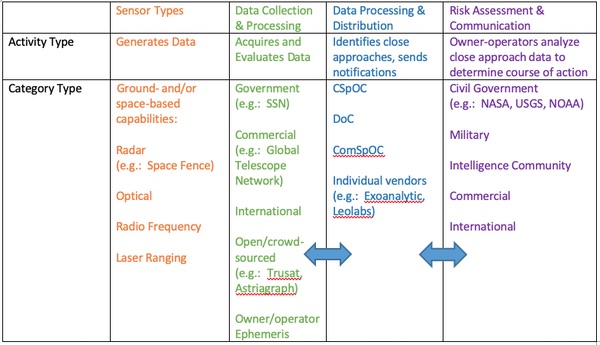 A simplified information flowchart for STM.[48] |
Endnotes
- David D. Murakami, Sreeja Nag, Miles Lifson, and Parimal H. Kopardekar. “Space Traffic Management with a NASA UAS Traffic Management (UTM) Inspired Architecture.” In AIAA Scitech 2019 Forum. San Diego, California: American Institute of Aeronautics and Astronautics, 2019.
- Bhavya Lal, Asha Balakrishnan, Becaja Caldwell, Reina Buenconsejo, and Sara Carioscia. “Global Trends in Space Situational Awareness (SSA) and Space Traffic Management (STM).” Institute for Defense Analyses/Science and Technology Policy Institute, April 2018, Appendix B. Instead of converging on specific definitions, these authors decided on an “analytic framework for a space traffic system.”
- Sandra Erwin, “Air Force: SSA is No More; it’s ‘Space Domain Awareness,’” SpaceNews, November 14, 2019.
- Daniel Oltrogge testimony, House Subcommittee on Space and Aeronautics, February 11, 2020, p. 3.
- Much has been written about orbital debris. Regarding these two incidents, see, for example, Phillip Anz-Meador, “Top Ten Satellite Breakups Reevaluated,” NASA Orbital Debris Quarterly News, January/April 2016, pp. 5-6. The destruction of China’s Fengyun 1C satellite produced 3,442 cataloged pieces of debris and the Iridium 33-Cosmos 2251 crash produced 628 cataloged fragments. See Phillip Anz-Meador, John Opiela, Debra Shoots, and J.C. Liou, History of On-Orbit Satellite Fragmentations, 15th edition (NASA TM-2018-220037), pp. 22 and 21, as well as pp. 423 and 411, respectively.
- Dave Mosher, “India’s Anti-Satellite Missile Test May Have Created 6,500 Pieces of Space Junk Larger than a Pencil Eraser, According to a New Simulation.” Business Insider, March 29, 2019.
- Oltrogge testimony, p. 11 notes a four percent figure currently but doesn’t indicate a minimum size threshold. The U.S. Space Surveillance Network has been able to routinely track objects larger than 10 cm, of which more than 23,000 pieces of orbital exist. Experts estimate that there are about 500,000 particles between 1 and 10 cm and more than 100 million particles larger than a millimeter. Ground-based radars have been able to detect particles 3 mm or larger See: https://orbitaldebris.jsc.nasa.gov/faq/.
- “Megaconstellations” are more formally and simply known as “large constellations” in SPD-3. See, for example, Stephen J. Garber and James Vedda, “Déjà Vu or Sea Change? Comparing Two Generations of Large Satellite Constellation Proposals,” The Space Review, July 2019. SpaceNews published a useful graphic depiction of the main proposed megaconstellations, “LEO and MEO Broadband Constellations,” March 12, 2018, p. 14.
- See, for example, “TANSAT: China Launches Satellite to Study Greenhouse Gases and Climate Change,” December 21, 2016; Jeff Foust, “Earth Science Discussion Latest Sign of NASA-China Ties,” SpaceNews, August 5, 2016; and “TanSat – Spacecraft & Satellites”.
- The small FCC fine suggests ignorance or confusion on the part of the company and an opportunity to clarify the FCC regulations. (The FCC is known to have a history of making inconsistent decisions on licenses, which is part of the challenge of new technology.) If Swarm Technologies really wanted to launch without a FCC license, then they could have legally done so by making the owner/operator of the satellite a non-US entity. In any event, by April 2020, Swarm Technologies announced that it had received full FCC licensure. See Sara Spangelo, “Swarm Gains Full Regulatory Approval to Operate Commercially,” April 6, 2020.
- Ian Christensen, “Unlicensed Swarms in Space,” The Space Review, April 2, 2018. Ironically, another author noted that the passive radar reflectors were actually developed by the US Navy. See Mark Harris, “FCC Accuses Stealthy Startup of Launching Rogue Satellites,” March 9, 2018.
- Caleb Henry, “FCC fines Swarm $900,000 for unauthorized smallsat launch,” SpaceNews, December 20, 2018.
- Christensen.
- Holger Krag was quoted in Jon Brodkin, “SpaceX Satellite Was on ‘Collision Course’ until ESA Satellite Was Re-Routed.” Ars Technica, September 3, 2019.
- Brian Weeden was quoted in Marina Koren, “SpaceX Missed Some Urgent Emails About a Satellite Standoff,” Government Executive, September 16, 2019.
- See, for example, Mike Wall, “No Space Crash: Dead Russian Satellite Just Missed an Old Habitat Prototype in Orbit,” September 18, 2019.
- For an excellent account of just how close these satellites may have come to each other over the city of Pittsburgh, see Matthew Shouppe, “The IRAS/GGSE 4 Close Approach,” January 31, 2020. Also see Jeff Foust, “Potential Satellite Collision Shows Need for Active Debris Removal.” SpaceNews January 29, 2020. After the fact, Kevin O’Connell from the DoC reported that the risk jumped from 1 in 1000 to 1 in 20 “[t]hroughout the day” and for context, that owner-operators typically plan collision avoidance maneuvers for active satellites when the risk exceeds 1 in 10,000. See his testimony before the Senate Commerce, Science, and Transportation Committee on February 12, 2020, p. 2.
- Regarding the catalog, SSN personnel assign a unique identifier to every object whose origin can be traced. See, for example, Joe Pappalardo, “Why the Pentagon Is Suddenly Declassifying Lots of Info About What's in Orbit,” December 13, 2018.
- See, for example, https://www.celestrak.com/columns/v04n01/. Most of the sensors are in the Northern hemisphere because the system was originally built as an early warning system to alert against Soviet missiles during the Cold War.
- The rest of this quote from Brian Weeden is ‘It’s an email saying, “This object is coming close to an object that you own.” If you want advice on the best course of action, they’re not able to help.’ See Mark Harris, “NASA Is Quietly Helping Satellite Firms Avoid Catastrophic Collisions.” New Scientist, December 5, 2019.
- Harris, “NASA is Quietly Helping.” This article notes that Maxar Technologies continues to pay NASA for a service that is similar to LeoLabs.
- Thanks to Dr. Dana Johnson for raising this point in a verbal discussion. See Quentin Verspieren, “Military Influence on International Regime-Making for Space Traffic Management: Explaining the Evolution of SSA Data Transparency at the US Department of Defense,” International Astronautical Congress Colloquium on the Law of Outer Space, October 2019, for more details on the nuances of this process. This effort began in 2004, when the Air Force Space Command initiated the Commercial and Foreign Entities Pilot Program. In 2009, the US Strategic Command took over the program and renamed it the SSA Sharing Program. See Tiffany Chow, “Space Situational Awareness Sharing Program: An SWF Issue Brief” (Secure World Foundation, September 22, 2011) p.2.
- See, for example, Mike Gruss, “U.S. Air Force Seeks New Space Situational Awareness Data to Track Threats,” SpaceNews, November 16, 2015.
- See: https://www.space-data.org/sda/ and Oltrogge testimony, p. 8. The Space Data Association is completely different from DoD’s Space Development Agency, which was established in 2019.
- See: https://agi.com/comspoc .
- About four years ago, AGI Vice President Paul Welsh was quoted as saying that ComSpOC’s “potential customers include military organizations, intelligence communities, civil space agencies, commercial operators and allied governments. Really anyone who has a need for data services related to general SSA…” See Caleb Henry, “ComSpOC Expects to par with JSpOC’s Public Catalog This Year,” March 31, 2016. At that time, Welsh estimated ComSpOC tracked about half of all objects in the public catalog for LEO and that percentage likely is much higher now.
- Quentin Verspieren, and Hideaki Shiroyama, “From the Seas to Outer Space: The Reverse Dynamics of Civil-Military Situational Awareness Information and Responsibility Sharing.” Space Policy 50, November 2019, p. 4.
- See: https://www.space-data.org/sda/space-data-center-3/ and Oltrogge testimony, p. 8. Re SDA’s shielding and retransmission of potentially proprietary data, see Christine Leurquin, “Introduction to the Space Data Association,” November 3, 2011, pp. 13, 19, 21.
- See https://exoanalytic.com/space-domain-awareness/ . ExoAnalytic is also partnering with NorthStar Earth and Space, a Canadian firm that aims to launch of constellation of 40 SSA spacecraft. See Caleb Henry, “ExoAnalytic, NorthStar E&S Team Up on Space Situational Awareness,” SpaceNews, April 1, 2019.
- See Caleb Henry, “LeoLabs Planning to Triple Number of Radar Sites for Space Debris Tracking by Early 2020s.” SpaceNews, October 9, 2019, and “LeoLabs Unveils Kiwi Space Radar: Ground-Breaking Radar Advances Space Traffic Safety in LEO (News Release),” October 14, 2019.
- LtCol. Matthew C. Smitham, “The Need for a Global Space-Traffic-Control Service: An Opportunity for US Leadership,” Air University Maxwell Paper No. 57, 2012, p. 157; https://www.globalsecurity.org/space/world/russia/space-surveillance.htm; and Brian Weeden and Victoria Samson, Global Counterspace Capabilities: An Open Source Assessment (Secure World Foundation, April 2020). pp. 2-25 – 2-27.
- See: http://www.unoosa.org/pdf/pres/stsc2014/tech-26E.pdf and Oltrogge testimony, p. 7.
- See: https://www.esa.int/About_Us/ESAC/Space_Situational_Awareness_-_SSA; https://www.eusst.eu/; https://ec.europa.eu/growth/sectors/space/security_en; and Oltrogge testimony, p. 7
- See Brian Weeden and Victoria Samson, editors, Global Counterspace Capabilities: An Open Source Assessment (Secure World Foundation, April 2020), pp. 4-2 - 4-3 and the various sources there.
- See: https://satnogs.org/faq/ .
- TruSat White Paper.
- Theresa Hitchens, “Crider: SSA Data ‘Library’ Will Open to Allies,” Breaking Defense, May 3, 2019, and O’Connell testimony, p. 5
- NASA’s A-train approach to collision avoidance for satellite safety is here: https://satellitesafety.gsfc.nasa.gov/CARA.html and CARA’s software is here: https://software.nasa.gov/software/GSC-18068-1, https://software.nasa.gov/software/GSC-18016-1, https://software.nasa.gov/software/GSC-17900-1, and https://software.nasa.gov/software/GSC-18072-q.
- See: https://www.whitehouse.gov/briefings-statements/president-donald-j-trump-achieving-safe-secure-future-space/ .
- See, for example, O’Connell testimony, pp. 1-2.
- Astriagraph is an example of a crowdsourced, open-source system that pulls data from commercial, Federal, international, and nonprofit sources, as mentioned by Moriba Jah in his testimony before the Senate Commerce, Science, and Transportation Committee on February 12, 2020. His testimony on pages 10-11 also offers some clear visualizations of Astriagraph versus component data sources.
- Jah testimony, pp. 13-14.
- Brian Weeden testimony before the House Subcommittee on Space and Aeronautics, February 11, 2020, p. 18. Counter to this notion, in a “covering all bases” approach, a few years ago, the Defense Advanced Projects Agency (DARPA) initiated an effort called the Hallmark program to “fuse [SSA] information from diverse sources…to expedite the creation and assessment of a comprehensive set of new and improved tools” that CSpOC could use. See, for example, https://www.darpa.mil/program/hallmark and Loren Blinde, “Ball Aerospace Selected for DARPA Hallmark Phase2,” March 11, 2019.
- Daniel Moomey, Austin Potter, John C. Matchett, Jennifer Thielke, “Trending Analysis of Historical Conjunction Data Messages,” Journal of Space Safety Engineering, January 2020, p. 45.
- Weeden testimony, pp. 3, 11, 13, and 17, Brian Weeden, “Going Blind: Why America is on the Verge of Losing its Situational Awareness in Space and What Can be Done About it,” September 10, 2012. In his testimony, Weeden notes that DoD is trying to address the gaps in LEO coverage by siting facilities in the Southern hemisphere but that this is still a major issue. Regarding Southern hemisphere coverage, LeoLabs recently began operating its “Kiwi Space Radar” in New Zealand, touted as the “first commercial radar to track objects in LEO smaller than 10 centimeters.” See “LeoLabs Unveils Kiwi Space Radar,” news release, October 14, 2019. Regarding ground-based sensors, Oltrogge notes, on p. 7 of his testimony, that companies have fielded hundreds of sensors, as compared with fewer than 20 SSN ground-based sites. On p. 13 of his testimony, Oltrogge also reinforces the point that SSN sensors were built in “piecemeal” fashion for missile warning. In 2012, Smitham noted that US algorithms were less robust than Russian ones. See Smitham, p. 159 and Brian Weeden, “The Numbers Game: What's in Earth Orbit and how do We Know?,” The Space Review, July 13, 2009.
- See, for example, Jerry Krassner and Moriba Jah’s comments at a panel, “Space Domain Awareness: Building Trust in the Data,” Aerospace Corporation and the George Washington University, March 9, 2020, author’s notes and video available, and Jah’s formal “Quantifying and Assessing ‘Truth’ for Effective Multi-Source Information Fusion” powerpoint presentation from that panel.
- Stefan Kaiser, “Legal and Policy Aspects of Space Situational Awareness,” Space Policy, February 2015, p. 7.
- For another useful take on this data, see the flowchart on p. iv of Lal, Balakrishnan, et. al.
Note: we are temporarily moderating all comments submitted to deal with a surge in spam.