Buccaneers of the high frontier: Program 989 SIGINT satellites from the ABM hunt to the Falklands War to the space shuttleby Dwayne A. Day
|
| “FARRAH was the only SIGINT satellite collector capable of collecting data in both the northern and southern hemispheres,” the history states. “This capability was used very effectively to provide the only SIGINT satellite support to the British during the Falklands war from April to June 1982.” |
In 1978, four years before the launch of FARRAH I, National Security Agency (NSA) and NRO personnel pushed to dramatically improve the ground processing of satellite data to achieve near-realtime processing. The existing processing software was incredibly slow and new software had to be developed. The new software made it possible to process the data and deliver it to the National SIGINT Operations Center at the National Security Agency within three minutes of intercept.
In response to a Mandatory Declassification Review request, the NRO released more sections of its official signals intelligence satellite history. “FARRAH was the only SIGINT satellite collector capable of collecting data in both the northern and southern hemispheres,” the history states, although according to another source with direct knowledge of the program, most of the satellites had some capability to collect in the southern hemisphere. “This capability was used very effectively to provide the only SIGINT satellite support to the British during the Falklands war from April to June 1982.”[3]
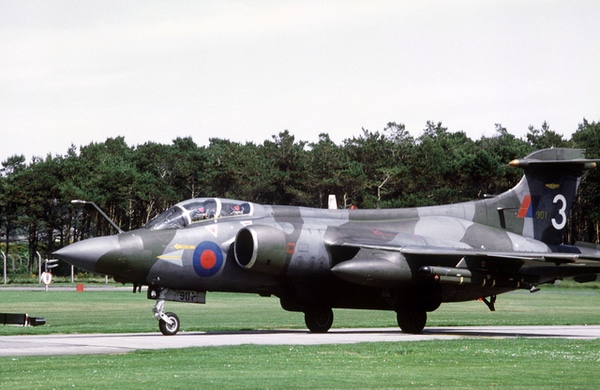 A Buccaneer attack aircraft. In 1982, the United Kingdom considered an audacious plan to fly Royal Air Force Buccaneer attack aircraft on a long-range mission to attack Argentina’s aircraft carrier ARA Venticinco de Mayo in Argentine territorial waters. Targeting information would probably have been provided by an American FARRAH I signals intelligence satellite launched on May 11, 1982. (source: Wikipedia) |
Carrier attack
Gibson’s article quoted an RAF planning document stating that the Buccaneers’ mission was “to degrade the fighting capability of major ships of the Argentine Navy operating inside the 12 n.m. limit. The highest-value target is the aircraft carrier Veinticinco de Mayo, which is currently believed to be in the Puerto Belgrano area.”
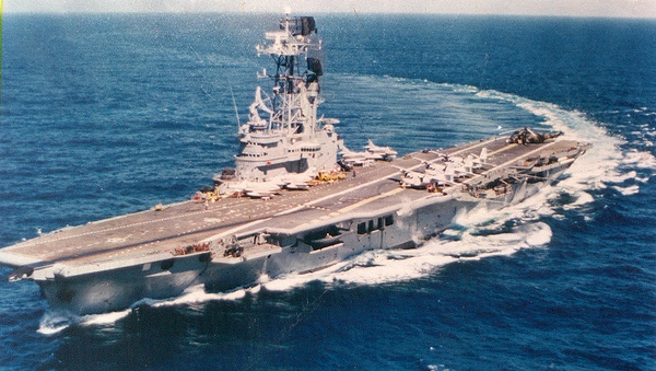
The carrier’s name in English was Twenty-fifth of May, which is the date of Argentina’s May Revolution in 1810. It was equipped with a Hollandse Signaalapparaten (HSA) LW-01 air surveillance radar that was old but still capable, and nowhere near as sophisticated as the latest Soviet radars that the NRO satellites regularly pursued. The carrier was originally built for the Royal Navy as HMS Venerable and later served in the Royal Netherlands Navy as HNLMS Karel Doorman, which is where it obtained the radar. Assuming that the radar was emitting, the FARRAH satellite could have intercepted and identified it, and determined its location. That data could have been provided to British forces to aid in their attack.
Each Buccaneer would have been armed with two AJ.168 TV-Martel television-guided anti-ship missiles on wing pylons as primary weapons. They would have also carried four 1,000-pound (454-kilogram) bombs in the weapons bay. The planes would have launched one TV-Martel each, keeping the second one as backup if they were to conduct a second attack, and the bombs in reserve if the missiles failed.
The carrier was equipped with twelve Bofors 40 mm anti-aircraft guns. It also had American made Douglas A-4Q Skyhawks with 20 mm cannons that could also carry AIM-9B Sidewinder air-to-air missiles. Surprising the carrier before it could launch any defensive aircraft was important for success. After the attack, the planes would have flown over the South American peninsula to Chile, landing without notice or permission in a nation friendly to the United Kingdom.
Program 989
The Program 989 satellites did not start out with the mission of supporting tactical forces. Instead, they collected information that often took weeks or even months to process and were primarily used for strategic intelligence on Soviet weapons systems as well as assisting American strategic forces to avoid Soviet defenses.
| The main problem with obtaining customers for the P-11 satellites was that it was very difficult to find suitable rides for them, satellites going to the right orbit and at the right time. This has proven the bane of any secondary payload, even today. |
The first satellite was named “Hitchhiker” and was built by Lockheed for ARPA to measure radiation in Earth orbit. That satellite was launched in 1963 but failed to reach orbit. The satellites were mounted to the “aft rack” of Agena upper stage rockets. The Agena served as the second stage for Atlas and Thor launches, and also served as a satellite bus for many CORONA and GAMBIT reconnaissance missions. The missions provided a free ride to orbit—hence the name “Hitchhiker.” Because CORONA and GAMBIT missions launched every few weeks, the NRO sought to take advantage of this opportunity. Unfortunately, not every CORONA or GAMBIT launch was suited to carry the extra satellite, and identifying possible carrying missions proved troublesome throughout the life of the program.
Lockheed named the satellites “P-11,” for “Program 11.” But according to Jon Bryson, an Air Force officer who ran several of the satellite projects in the late 1960s and early 1970s and later ran the entire program, P-11 was only “for marketing purposes” and Air Force and National Reconnaissance Office personnel did not use that designation. Because Program 989 was a small program, practically done on a shoestring budget, Bryson believed it did not get a lot of quality assurance attention that other Lockheed programs did, but the satellites generally worked well.
Over the three-decade life of the program, Lockheed built several dozen satellites for the NRO. The company sought to find other customers for the P-11 and even produced a marketing brochure in the mid-1960s touting its value for civil missions such as weather monitoring, but found no takers. Lockheed later offered the satellite for civil and commercial users in the 1980s, but again had no success. All of the flown Program 989 satellites were spin-stabilized, but Lockheed offered a three-axis-stabilized version of the satellite, which would have been more sophisticated and expensive. The company also offered a gravity-gradient-stabilized version, but “nobody could figure out how to use it,” Bryson explained. Spin stabilization worked fine for NRO missions and was cheaper than three-axis stabilization. The main problem with obtaining customers for the P-11 satellites was that it was very difficult to find suitable rides for them, satellites going to the right orbit and at the right time. This has proven the bane of any secondary payload, even today.
 CALSAT was a USAF version of the Lockheed P-11 satellite. It was intended to aid in calibration of ground-based satellite tracking systems. Because of technical problems it never flew. It was on display in the National Museum of the United States Air Force before being removed at least a decade ago. It is presumably in storage and is probably the last existing P-11 satellite. (photo by author) |
There was one other non-NRO satellite, named CALSAT. It was a calibration satellite that was supposed to have active features for testing the calibration of US space tracking radars. However, the Air Force could not make the satellite work right and never launched it. That satellite later ended up in the National Museum of the United States Air Force, although it was removed from public view over a decade ago and its whereabouts are currently unknown.
The satellites were around the size of a suitcase, and people who worked on them occasionally referred to them as looking like a suitcase. They initially weighed about 104 kilograms (230 pounds). They would be levered off the side of the Agena aft rack on a device engineers called a “stepladder” because of its shape, and pushed off by springs. Small solid propellant motors would fire to spin the satellite up to more than 70 rpm, and then a solid motor in the center of the spacecraft would fire to boost the orbit. Upon reaching the proper orbit, another solid motor pointed in the opposite direction and fired to circularize the orbit.
By the mid-1960s, the satellites were part of Program 989, often abbreviated as “P989” by the people who worked on them. Each Program 989 satellite had a mission number and usually two separate payloads each with their own code name like PUNDIT, SAVANT, TIVOLI, or MABELI.
The SIGINT payloads on the satellite were mounted in two compartments along the long sides of the spacecraft, and often the satellites had two different payloads that sometimes shared the same antennas—which is why many of the satellites had two names and mission numbers. The satellite antennas would then deploy out the sides of the spacecraft, most of them pulled out by the centrifugal force of the spin. Some of the satellites had antennas nearly two meters in diameter, larger than the length of the satellite. But the antennas were very low mass compared to the satellite itself, so even when some of them occasionally did not fully deploy at first, they did not affect the spinning satellite. If there was a problem with deployment, ground controllers could do some things to shake them loose, but the centrifugal force was so great that the antennas eventually deployed.
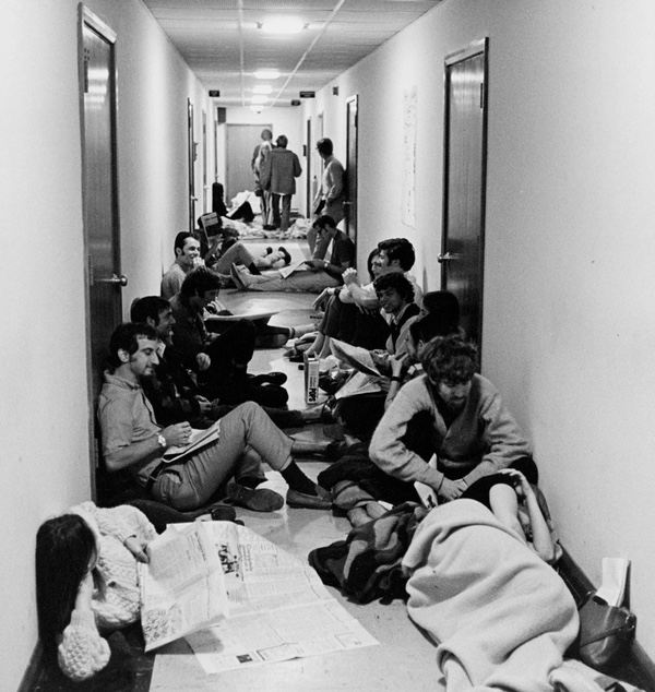 Students occupying the Stanford Applied Electronics Laboratory building in April 1969. An engineer slept in his lab overnight to protect the safe containing top secret information on the signals intelligence satellite payload that he was building. Jon Bryson and some other Air Force officers from a nearby facility went through the student protestors and removed the safe and its contents without incident. (source: Chuck Painter) |
The SIGINT payloads were often manufactured by different companies and organizations. One of the manufacturers in the 1960s was the Stanford University Applied Electronics Laboratory. In April 1969, student protestors occupied the laboratory building, and the head of the SIGINT projects there, James de Brockert, was standing watch over his laboratory when the students moved in. He slept there overnight, protecting the safe and its classified contents. The next day, Jon Bryson was one of the Air Force officers sent to retrieve the safe. The students got out of their way and did not prevent them from wheeling the safe out of the building and outside to a waiting van. The Air Force personnel took it to a secure facility. Stanford leadership chose to close the laboratory, and de Brockert and his people established a private company to continue producing the payloads.
Program 989 was managed at the NRO’s Los Angeles office, known as the Secretary of the Air Force Special Projects Office, often abbreviated as “SAFSP,” or simply “Special Projects.” Bryson had worked for the NSA at the Sunnyvale ground control facility south of San Francisco (often referred to as the “Blue Cube”)—which is why he had been tasked with retrieving the safe and its contents at Stanford University—but had then been transferred to Special Projects in Los Angeles. By the late 1960s, SAFSP had about 200 people. Most of them were Air Force officers assigned to the NRO. There were also around three or four Navy personnel, and one from CIA. They occasionally had a few people loaned from other agencies. To work at SAFSP, “you didn’t have to be the sharpest guy on the block,” Bryson joked, “but you had to be close.” It was important that they be technically capable and Bryson had a degree in electrical engineering. Unlike the Naval Research Laboratory, SAFSP did not build any spacecraft or instruments. They hired contractors to do that, like de Brockert at Stanford, Lockheed in Sunnyvale, and other companies around the country, and so the personnel overseeing the contractors had to be able to ensure that the contractors were doing the work properly. In 2000, Bryson was recognized as a “Pioneer of National Reconnaissance” by the National Reconnaissance Office, which noted that “Colonel Jon Bryson directed the development, acquisition, and operation of a Program A signals intelligence satellite system that handled rapidly increasing data rates.” That occurred later in his career.
For the Program 989 satellites, the primary limitation on their lifetime was atmospheric drag due to the relatively low operating altitude. The satellites were not high enough above the thin reaches of the atmosphere to stay up longer than 9 to 12 months, and drag reduced their spin rate over time.
| The mass on the satellites increased significantly. One of the people working on the program eventually told Bryson that he did some calculations, “and this thing is denser than oak lumber.” |
The satellites had a rotation axis that was parallel with the Earth, pointing in the direction of flight. The antennas would quickly sweep over the ground as the satellite rotated, and when one antenna swept over the target another would rotate into position. They could detect signals from the ground, but also apparently occasionally intercepted signals from satellites above them. Many of the satellites were designed to collect electronic order of battle data, meaning recording the locations and types of Soviet radars in the Soviet Union. EOB data was processed by the 544th Recon Tech Wing at Omaha, Nebraska, Headquarters for Strategic Air Command. The wing had a sub-branch called the Defense Analysis Center that created the “EOB packages,” data that was put into the electronic systems on strategic bombers and other platforms. Some of this data was important for the Single Integrated Operational Plan, or SIOP, the nuclear war-fighting plan.
The satellite payloads usually had one or more of several missions:
- Directed coverage—gathering everything about a specific emitter
- General search—covering a wide geographic area, looking for known and new signals
- Technical intelligence—attempting to get modulation and internal signal characteristics from a radar
A key goal was trying to determine the “field of regard” for a radar, or where it was pointing and what it could detect in its beam. Even if the satellite’s antenna was not pointing directly at the radar emitter, it was often possible to obtain information from the radar sidelobes. In fact, it was sometimes possible to get more data from the sidelobes than the main beam.
The satellites had horizon sensors that detected the CO2 in the atmosphere, indicating when each side of the satellite crossed the horizon and was facing either Earth or space. The horizon sensor data and other data (like temperature, battery power, etc.) was all read into the telemetry block on the tape recorders. The tape recorders had two lines, one for telemetry and another for intelligence data. After the data had been transmitted to the ground, analysts took timing data, horizon data, and the collected intelligence data, and processed it to determine where the satellite was in its orbit and where the antennas were pointed when they collected their signals. This provided a direction to the target. Combining this data with information collected on subsequent orbits helped to improve the accuracy of the geolocation of the emitters.
The Program 989 satellites recorded their data over the Soviet Union and then they played back the recordings when commanded to do so by an American ground station. The tapes played back over the ground stations at four times the rate they were recorded. It was not a good thing if the satellites were still playing back their recorded data when they went out of view of a ground station—something the controllers referred to as going “over the hill hot”—and they really did not want to be transmitting over the Soviet Union where a ground station could pick up the transmissions and determine what the satellite was doing. The Program 989 satellites usually did not encrypt their downlinks.
The early satellites had thirteen telemetry channels. They covered things like the onboard clock (“timing”), horizon sensor, sun sensor, temperature, power supply, and some payload telemetry. The way the system worked was that the onboard telemetry system checked on each channel (like the clock, sun sensor, etc.) in sequence, continuously, so 1, 2, 3… 13, then 1, 2, 3… 13. That data was all recorded onto part of a magnetic tape, then played back over a ground station. There was a system on the ground for separating it all out, so that all the data from channel 1 was added up, all the data from channel 2 was added up, and so on.
In the mid-late 1960s, Lockheed changed to the much more capable ANGSQ-53A telemetry system. This was a standardized telemetry system that was used on other spacecraft, although it was repackaged to fit on the Program 989 satellite. This system had 48 channels instead of 13, and it time-sampled the data outputs and recorded them sequentially, a so-called “poor man’s digital system.” It could record to the tape recorders, but also transmit in real time when over a ground station. The satellites did not need all 48 channels.
 Leach made magnetic tape recorders used on many spacecraft, including the Program 989 satellites, where they recorded both satellite telemetry and intelligence data. Some Leach recorders would last forever, but others died early, and despite substantial effort, Leach engineers could not figure out why they failed. |
The satellites were equipped with Leach tape recorders, and over time the engineers added more tape recorders for both data and redundancy. Bryson remembered that late-model satellites eventually had four, and the increased bandwidth of the tape recorders made it possible to record much more data, including spacecraft health data such as temperature, power supply, battery health, and so on. Bryson recalled that the tape recorders proved to be a perpetual headache for the program. Some of them died after reaching 10,000 cycles, whereas others lasted forever. Leach engineers could not figure out why some of them died prematurely. Because Lockheed was using so many Leach tape recorders in their satellites, they eventually bought the tape recorder company.
The mass on the satellites increased significantly. Whereas the early satellites weighed about 104 kilograms (230 pounds), by the 1980s the satellites were launching from the sides of HEXAGON reconnaissance satellites and they weighed nearly four times as much—a hefty 399 kilograms (880 pounds). Although the outer shape line did not change, engineers filled up all the internal space with electronic equipment. Eventually the top angle panels became less shallow, more like a squat, thick pyramid rather than a pointy pyramid. One of the people working on the program eventually told Bryson that he did some calculations, “and this thing is denser than oak lumber.”
Chasing radars and missile telemetry
Several of the satellites launched in the early-mid-1960s were designed to intercept Soviet air defense radars. But one series of satellites named PUNDIT were focused on Soviet missile telemetry—the signals that Soviet missiles emitted during flight tests.
| Despite the fact that the launch was packed with NRO satellites, any delay in launching the payload was no longer an NRO decision but instead had to go up to the White House. A classified cable from national security advisor Henry Kissinger said, “We’re not gonna wait ten minutes.” |
Charles C. Tevis was an analyst who had pushed for telemetry interception satellites in low-Earth orbit starting in the early 1960s. The first one was to be named SIVET—Tevis spelled backwards. But the name was changed, probably for security reasons, to PUNDIT. According to one source, the name was supposedly a comment on Tevis’ widely-respected intellect. However, Bryson provided a different origin for the name. Most of the Program 989 satellite names were picked by Bill Harris at Lockheed. Often the names were somehow related to their missions. SOUSEA was focused on Southeast Asia[4] TIVOLI was an acronym—or more likely, a “backronym,” where somebody picked a name and then tried to turn it into an acronym, coming up with the puzzling term “Technical Intelligence Vehicle Orbital Life Indefinite.”[5] LAMPAN focused on L-band radars and was carried with SAMPAN, which focused on S-band radars.[6] VAMPAN focused on VHF emissions.[7] According to Bryson, PUNDIT may not have been a nod to Tevis’ brilliance but was instead based on Harris’ football allegory that “When you’re on your own 30 and it’s fourth down, you pundit”—in other words, the intelligence community badly needed better missile telemetry data. PUNDIT was a desperation move—punting the ball—because satellites spent so little time over the target that they had a very low probability of flying over a Soviet missile test range while a missile was in flight.[8]
The first PUNDIT satellite was launched in October 1963, followed by three more—one of them failing to orbit—with the last one in April 1965. The follow-on satellites, launched in 1967 and 1969, were named SAVANT, also possibly a nod to Tevis’ intelligence. The early PUNDIT satellites did not collect much telemetry, but indicated that the signal environment was very dense and required careful sifting. Electronic Systems Laboratory conducted an analysis of the signals environment and built the payload for the last satellites. The analysis led to improved collection systems that could filter out the extraneous signals, and SAVANT was reportedly more successful than its predecessors in gathering Soviet missile and rocket signals.[9,10] (See: “Wizards redux – revisiting the P-11 signals intelligence satellites,” The Space Review, September 7, 2021.)
 The SAVANT II satellite was launched in the late 1960s and designed to intercept signals from Soviet rockets and missiles. It scored a major intelligence coup when it intercepted signals from the reentry vehicle of a Soviet Fractional Orbital Bombardment System missile. The missile's launch telemetry had previously been intercepted by a ground station. These intercepts provided telemetry from nearly all the important phases of the missile's flight. (credit: NRO) |
The Soviets used a telemetry system adapted from the German V-2 rocket for most of their missile and space systems. According to a declassified 1971 document, 25% of SAVANT’s intelligence covered anti-ballistic missile targets, 70% covered ICBM targets, and 5% was “other,” which may have included space launches.[11] But SAVANT II, which was launched in 1969, achieved a major intelligence coup.[12] At the time the Soviet Union was testing a Fractional Orbital Bombardment System (FOBS) that would place a large nuclear warhead in a low orbit and then deorbit it as it approached American territory. The Soviets launched a FOBS missile on a test and an American telemetry listening post in Iran captured the launch telemetry. By sheer luck, SAVANT happened to be in just the right position to get the telemetry after the reentry vehicle had emerged from blackout caused by ionization in the atmosphere. The satellite was able to intercept everything except the arming fusing signals for the warhead.
But things did not always go right for the little satellites, and sometimes that was for odd reasons. One of the satellites was known as WESTON.[13] WESTON was one of the few Program 989 satellites that had a communications intelligence mission, designed “to intercept, recognize, and record Mercury Grass and Dawn Rose communications signals in the 60 to 70 MHz and the 360 to 420 MHz frequency bands,” according to a mission summary. WESTON would “measure the frequency and power of the intercepted signal,” but would not geolocate the targets. [14]
Mercury Grass was a NATO reporting name for a truck-mounted communications system used by the headquarters of SA-2 Guideline surface-to-air missile emplacements to communicate with their battalions, and much more importantly, used by Soviet field units to communicate back to Moscow. It was apparently a very clever and sophisticated communications system that Western intelligence agencies had discovered almost by accident. The Soviet Dawn Rose communications system’s purpose is unknown, but it operated in the 360–410 megahertz frequency band.
WESTON had been delayed for flight, but the intelligence community wanted to determine how well it would work. At the time, the US Air Force was flying covert intelligence collection missions using Air Force transport aircraft flying along the Berlin Air Corridor. They would fly to and from Berlin in East Germany, recording signals and taking photographs. The intelligence community flew the WESTON payload on a C-130 during one of these missions. According to Bryson, the payload operated beautifully “and the guys on those flights thought we were going to put them out of business” when they put WESTON into orbit.
When Lockheed shipped WESTON from their Sunnyvale factory down to Vandenberg Air Force Base for launch it had a problem. Something went wrong with the power system during testing at the launch site. Jon Bryson talked to Lockheed and they replied that they needed a week to fix the problem, which meant a one-week launch delay. WESTON was due to fly with a bunch of other satellites, including several signals intelligence payloads. But Bryson said that at this time “they were counting silos in Washington”—preparing for Strategic Arms Limitation Talks (SALT) arms control negotiations with the Soviet Union. Despite the fact that the launch was packed with NRO satellites, any delay in launching the payload was no longer an NRO decision but instead had to go up to the White House. Bryson sent the request to the NRO headquarters in Washington, DC, which submitted it to the White House. The next day he went to see the communications officer and asked “Do you have a message for me?” They responded “Boy, do we!” and they gave him a classified cable from national security advisor Henry Kissinger that said, “We’re not gonna wait ten minutes.”
WESTON was launched in September 1969 off the back of an Agena spacecraft that deployed numerous other satellites in orbit, including the four satellites of the POPPY 8 mission. WESTON was placed in a 442-by-477 kilometer orbit inclined 69.65 degrees. (See “Spybirds: POPPY 8 and the dawn of satellite ocean surveillance,” The Space Review, May 10, 2021.) But WESTON then suffered the predicted power supply failure that cut its life short. According to an official history, the satellite lasted nine months, but Bryson remembered that WESTON really only lasted a month.
Hunting ABMs
By 1966, President Lyndon Johnson was increasingly concerned with the problem of Soviet anti-ballistic missiles. Johnson was not so much concerned about Soviet ABMs themselves as he was the domestic political pressure he was feeling about them. He wanted firm intelligence about the actual Soviet ABM threat. In late 1966, an intelligence report indicated steps that the United States could take to increase collection of ABM intelligence. This included launching more Program 989 satellites and making modifications to other satellites such as POPPY and STRAWMAN. During the next several years, more Program 989 satellites had ABM collection missions. The intelligence community was particularly interested in ABM sites that had been spotted in photo-reconnaissance imagery around Moscow.
| The Secretary of Defense was impressed with all the assets going into understanding Soviet ABMs and remarked, “We’ve put more money into Sary Shagan than they have!” |
Detecting the ABM radars was a real challenge. “They had some really clever guys” in the Soviet Union designing those things, Bryson said, and the frequencies and operating modes of the big Soviet radars could be highly sophisticated. One signal that was detected from the big Soviet radar transmitter known as DOG HOUSE was initially very mysterious. It was just a powerful pulse separated by a long time until the next pulse. But upon closer analysis, American radar experts found that there was more going on inside the signal pulse.
Radar emissions could be spread across a big part of the spectrum. “Predetection” was a method of gathering up all the signals and sending them down. This can be compared to the way an FM radio works. There are FM signals traveling through the air, but your car radio gathers them and filters them down into a smaller frequency range that then plays over your speakers, cutting off the signal that is on either side of the station number. A predetection system doesn’t do that filtering, so that all of the data is retained and none gets lost. This was important for new signals that were not well understood, and particularly for the ABM systems.
The Soviets tested ABM radars as well as ABMs at a sprawling facility known as Sary Shagan. Although the US intelligence community believed Sary Shagan to be a testing site, some were never sure that it did not have an operational mission as well.
The TIVOLI satellite was designed to pick up the side lobes of the radar, which spread out a lot more than the main beam and therefore are easier to detect. But one satellite “walked right into the main beam” of the radar, Bryson said. Totally by accident, TIVOLI gathered a lot of data about the radar.
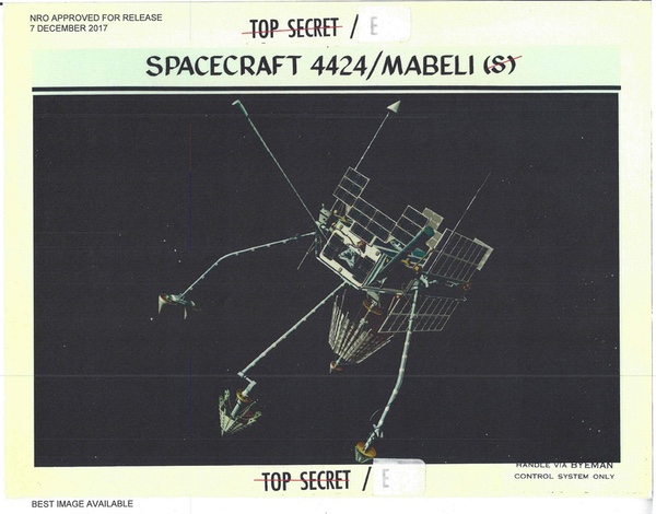 MABELI was an early 1970s satellite for intercepting signals from Soviet anti-ballistic missile radars. At one point its sensors were over-saturated by a powerful radar beam, but operators developed a clever method of using it so that the signals were weak enough to be recorded. (credit: NRO) |
In the early 1970s, the NRO launched the MABELI satellite. MABELI was designed to go after the main beam of an ABM system. Bryson joked that the main beam of the big Soviet radars put out so much energy that “it can melt the paint job” on the satellite. MABELI reached orbit, but when it sent back data it was incomprehensible, sort of like a sine wave going from the top to the bottom of the screen. The analysts were mystified. But eventually one of them noticed something at the end of the recorded tape, as the satellite was going over the horizon and losing the radar signal. What they determined was that the signal was so powerful that it was saturating the receivers on the satellite. The analysts then dealt with the problem “with some clever tasking” that made it possible for them to gather data without saturating the receivers.
At one point, members from the program office went to brief the Secretary of Defense about their efforts at collecting ABM signals, particularly everything that was focused on Sary Shagan. The Secretary was impressed with all the assets going into understanding Soviet ABMs and remarked, “We’ve put more money into Sary Shagan than they have!” It was that kind of collection that had dramatically improved the intelligence community’s understanding of the Soviet ABM program.
Another time one of the Program 989 ABM satellites overflew Moscow and was hit with a full radar blast that overwhelmed the satellite, indicating that the Soviets were tracking the satellite with the radar. The State Department wanted to file a formal complaint with the Soviet Union, claiming that tracking the satellite qualified as interfering with “National Technical Means” of verifying the SALT I arms control treaty, but the NRO objected, saying that doing so would indicate the satellite’s mission. (See: “Arms control and satellites: early issues concerning national technical means,” The Space Review, October 10, 2022.)
After all that expenditure and the launch of over a dozen satellites with ABM detection missions, it was clear that the Soviet ABM capability was very limited.
 Starting in the 1970s, some NRO signals intelligence satellites were named after actresses. The first of these was named after Ursula Andress, who had starred in the James Bond film Dr. No. At one point, the NRO Director was going to brief President Ronald Reagan about the programs and the program manager was concerned that he would have to change the satellites' names. But Reagan loved the fact that the satellites were named after people he knew. (credit: Eon Productions) |
URSULA
By the 1970s, the small satellites were getting increasingly sophisticated. One of the satellites started around this time was named URSULA.[16] Program manager Jon Bryson named it after Ursula Andress. Bryson said that he came up with an acronym for it, something like “Universal Reconnaissance…” NRO documents usually spell the name as URSALA, but sometimes URSULA.
URSULA was packed with a lot of new equipment, including a special feed in a big mesh dish that increased target location accuracy fourfold. Bryson proposed putting a processor on URSALA to process more data on the spacecraft as opposed to on the ground. It would have used a space-qualified computer. But according to Bryson, the NSA objected because it would have moved the processing to the satellite and the NSA was already heavily invested in doing processing on the ground.
| Eventually Major General Ralph Jacobson, then head of SAFSP, got involved in the argument with Vandenberg. He told the people at Vandenberg that “if a Titan II can put a payload [nuclear weapon] into Kiev, it can put a payload into orbit.” |
According to Peter and Cathy Swan in their 2015 book Birth of Air Force Satellite Reconnaissance there was a proposal for a “Direct Readout URSULA” that was to be named DRACULA. Bryson remembered there were several proposals for similar capabilities by the 1970s as the NRO sought to make the satellites more helpful to tactical forces. New high-altitude satellites already provided their data to the ground much faster than the small satellites in low orbits, which had to record it and then play it back later, but the small satellites could also send their information directly to terminals in the field.
In the mid-1970s the NRO sought to standardize the satellite bus in a project called “Cast Iron.” The satellites were also adapted to launch off the sides of the massive HEXAGON reconnaissance satellite that replaced CORONA in the early 1970s. HEXAGONs could carry up to two Program 989 satellites. Some HEXAGON satellites also carried a smaller Boeing satellite named the S3. Bryson said that the S3 was not as capable as the Program 989 satellite and was not a competitor for the intelligence mission.
Although SIGINT requirements were established at senior levels of the intelligence community, the program office at SAFSP often developed the capabilities in-house. Ideas for new payloads were generated in the program office which would take them to NSA, and if NSA said "do it" the NRO would then implement it.
Tuna cans
Throughout the 1960s, the NRO launched an average of three to four Program 989 satellites per year. By the early 1970s, as the NRO began to rely on higher orbit satellites for signals intelligence, the small P-989 satellites became less useful and the launch rate dropped off significantly, to one a year. The reduction was not due to cost, because the Program 989 satellites were inexpensive. In 1969 they cost $8 million apiece.[17] Even a decade later they were still far cheaper than other satellites. But Bryson joked that he once got chewed out by General David Bradburn, head of Special Projects, because his Program 989 satellite cost $25 million. They were cheap satellites, but somebody always wanted them to be cheaper.
By the late 1970s, the NRO was planning to transition many of its spacecraft to launch on the Space Shuttle. With the planned retirement of the GAMBIT and HEXAGON satellites, the Program 989 satellites would now have to find new rides to orbit. In the late 1970s there was a proposal to merge the Program 989 satellite mission with the Naval Ocean Surveillance Satellite mission. (See: “Red and black: The secretive National Reconnaissance Office finally faces the budgeteers,” The Space Review, April 11, 2022.) However, somebody familiar with the program said that this was “not a very serious proposal” at that time. It eventually happened over a decade later in the 1990s.
Rather than merge the 989s with another satellite mission, the NRO developed a plan to shift them to the shuttle and to pair them with launches of the Navy Ocean Surveillance Satellites, which were increasing in size and would launch in clusters on the shuttle using a Shuttle Launch Dispenser developed by the Naval Research Laboratory. This provided an opportunity to dramatically increase the Program 989 satellites in capability, size, and mass, and they went from the small “suitcase” satellites to a much larger “tuna can” design. Bryson was now in charge of the overall program.
The first suitcase P-989s weighed approximately 104 kilograms and had grown to almost 400 kilograms by the early 1980s. The tuna can weighed a whopping 1,451 kilograms (3,200 pounds). But that created problems. The Navy satellites already weighed a lot, and they had to be launched together. Adding a Program 989 tuna can to the shuttle launch would mean that the shuttle had to lift a lot of mass to orbit, which could only be accomplished with shuttle upgrades. Bryson realized that NASA was unlikely to upgrade the shuttle to provide that capability and so something would have to give—the Program 989 satellite would inevitably be bumped off the shuttle.
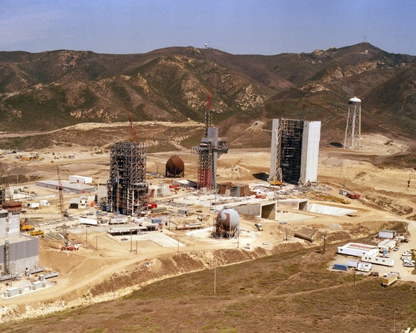 The Space Launch Complex 6 space shuttle launch pad under construction at Vandenberg Air Force Base in California in 1982. The military and intelligence communities planned to launch multiple payloads on the shuttle from this facility. Greatly enlarged Program 989 signals intelligence satellites were to be carried on classified shuttle launches along with Naval Ocean Surveillance Satellites. But these launches would have required upgrades to the existing shuttle vehicle. Eventually, the Program 989 satellites were pulled off the shuttle and launched on converted Titan II ICBMs instead. (credit: USAF) |
One day in the mid-1980s, Bryson was in the officer’s club at Los Angeles Air Force Base where SAFSP was located. He found himself talking to an officer in charge of missiles who said, “I can solve your problem.” It turned out that the officer was responsible for decommissioning the Air Force’s remaining Titan II ICBMs. Secretary of the Air Force Pete Aldridge agreed to shifting the Program 989 satellites from the shuttle to the Titan II. He also ordered that the Air Force shift the Defense Meteorological Satellite Program (DMSP) satellites to the Titan IIs as well, and there were many more DMSPs to launch than the classified satellites. The launch cost was eventually around $55 million, a relative bargain at the time.
| Although the history states that FARRAH was the only SIGINT satellite system used during the Falklands War, it is possible that a high-altitude communications intelligence system (COMINT) named VORTEX may have also been used to provide valuable intelligence to the British. |
The change to the Titan II was not entirely trouble-free. The Titan IIs had inertial guidance and Vandenberg only used radio guidance for their launches and would not allow the Titan II launches, despite having test-launched Titan II ICBMs from the base numerous times. Eventually Major General Ralph Jacobson, then head of SAFSP, got involved in the argument with Vandenberg. He told the people at Vandenberg that “if a Titan II can put a payload [nuclear weapon] into Kiev, it can put a payload into orbit.” Coincidentally, as a young captain in the Air Force, Jacobson had been the project engineer on the Titan II’s guidance system.
Although the Program 989 satellites moved off the shuttle first, eventually the Navy satellites also got booted from the shuttle. The NRL’s Shuttle Launch Dispenser was not allowed to use the shuttle after the January 1986 Challenger accident. It was later adapted for the Titan IV launch vehicle at considerable cost and renamed the Titan Launch Dispenser.[18]
From strategic intelligence to near-real-time operations
By the 1980s and with the debut of FARRAH, the satellites were capable of sending data down to smaller ground stations able to process it quickly. This opened up opportunities. The Program 989 office at SAFSP worked with the Army Space Programs Office to get the intercepted signals down to tactical users. They ran into a long-standing bureaucratic obstacle because the NSA wanted any recorded data looped through NSA before it went out to users. The solution to this was to develop a VHF tactical receiver for the satellite’s S-band downlinks and a satellite dish on vans that could deploy to the field. The satellites would direct downlink the data to the vans—recorded data would still go through the NSA.
There were four Army vans and one van for the F-117 stealth fighter program. They were called the Electronic Tactical User Terminal. The F-117 van was called the “Winchester System.” The systems were deployed during Operation Desert Storm in 1991. The F-117s had an electronic order of battle system, and the main purpose of the Winchester was to update the EOB with any recent changes, such as new radar emitter positions, so that the planes could avoid radar threats.
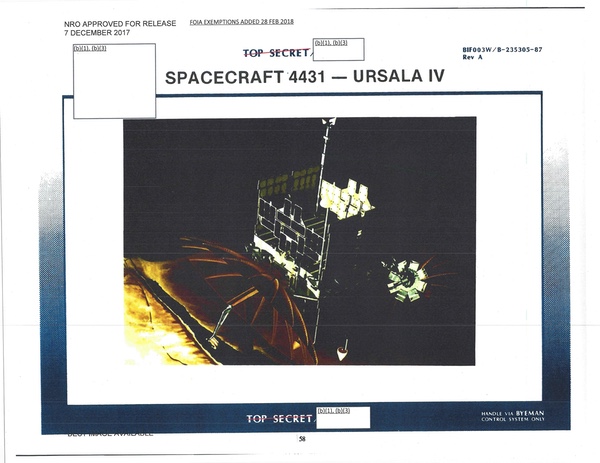 The URSULA IV satellite, launched in the late 1970s, may have played a role in detecting the Argentine cruiser General Belgrano and feeding that information to the Royal Navy, which sank her. Although often spelled “URSALA” in NRO documents, the satellite was named by Jon Bryson for actress Ursula Andress. (credit: NRO) |
From Falklands to Reagan
The official NRO history of its SIGINT satellite programs is still heavily redacted, with chapters on the high-altitude SIGINT satellites completely deleted. Although the history states that FARRAH was the only SIGINT satellite system used during the Falklands War, it is possible that a high-altitude communications intelligence system (COMINT) named VORTEX may have also been used to provide valuable intelligence to the British. (See “War at sea, seen from above,” The Space Review, April 25, 2022.)
National Reconnaissance Office Director Donald Kerr gave a speech at an NRO town hall meeting in December 2006, and the transcript was later released to GovernmentAttic.org. In a partially censored section of the transcript Kerr referred to the “25th birthday” of a satellite system—meaning it had been launched in 1981 (FARRAH was launched in 1982). The NRO had celebrated this event both at its headquarters near Dulles International Airport in Virginia and at another location, probably an overseas ground site. “It’s extraordinary that this machine born in the analog age is still serving the country in the digital age,” Kerr said. The mission of the satellite is deleted, but Kerr said, “It had to go to war with one of our allies shortly after launch and supported the United Kingdom in the Falklands War. It then came back, in fact to the central Asian theater, and provided notable service there. Now it’s covering the sub-continent India, Pakistan, Afghanistan, still doing significant work. It had a mean mission life of three or four years. Here we are 25 years later and it’s a tribute to the designers and more importantly those that have nursed it along as it displayed all of the symptoms of old age many times over.”
| Aldridge figured the female stars’ names would raise eyebrows for being sexist and he would have to change them. But when he showed him the slide, Reagan said, “Those are friends of mine! I love those names!” No change was required. |
Three years later, at the 2009 GEOINT Symposium, Director of the NRO Bruce Carlson mentioned an old spacecraft. “We have a satellite up there that is ten times older than we expected it to be. It has been up there this long [extends his arms out wide] and it has been up there this long [extends his arms out farther] and it’s still working. We expected it to do a mission that had to do with strategic, long-haul communications and today it’s helping us kill bad guys in the AOR [Afghanistan Area of Responsibility]. Now that’s as specific as I can get. But we do that because of the incredible contractor and NRO team that we have that nurses that satellite along and the young people that write software to change its functionality and keep it going.” FARRAH was not a “strategic, long-haul communications” satellite, so Carlson was clearly referring to another satellite, the same one Kerr had referenced earlier.
Although the NRO has now acknowledged that the FARRAH satellite played a role in the Falklands War, it is also possible that FARRAH’s immediate predecessor, URSULA IV, launched in 1979, was also used during the conflict. FARRAH I was launched on May 11, 1982, off the side of a HEXAGON reconnaissance satellite. According to the official NRO history, the modifications to the ground processing software that gave FARRAH a near-real-time capability began in 1979, meaning that they could have been applied years before FARRAH was launched, possibly to URSULA IV.[19] That raises the intriguing possibility that URSULA IV may have provided positioning data on the Argentine cruiser General Belgrano to the Royal Navy. The submarine HMS Conqueror sank the Belgrano on May 1, 1982. That sinking prompted the Argentines to pull their carrier back to safer home waters.
The Argentine government complained to the United States about providing satellite intelligence information to the British used to sink the Belgrano, and also made those charges in Telam, the official government wire service. The Argentine press—operating under a dictatorial government—repeated those claims. The US ambassador to Argentina struggled unsuccessfully to refute them.[20] The NRO at the time was also operating a series of ocean surveillance satellites, although there is no available information on their involvement in the war, unlike FARRAH, URSULA, and the unnamed “long-haul strategic communications” intelligence satellite.
Before ARA Veinticinco de Mayo had retreated to Argentine territorial waters, the ship had been searching for the Royal Navy’s fleet and engaged in a game of cat-and-mouse with the nuclear submarine HMS Splendid. British task force commander Rear Admiral Sandy Woodward wrote in his book One Hundred Days that, had Splendid located the carrier, he would have “Recommended in the strongest possible terms to the Commander-in-Chief Admiral Sir John Fieldhouse that we take them both out this night.” The proposed Buccaneer mission would have continued the hunt. According to Bryson, Woodward later told the Americans that having the satellite data was “like having one more destroyer and two more submarines.”
In the early 1980s, the Undersecretary of the Air Force and Director of the NRO Pete Aldridge was tasked with briefing President Ronald Reagan on the NRO’s various satellite programs.[21] Bryson became concerned. URSULA IV was launched in 1979, RAQUEL IA in 1978, and FARRAH I in 1982. Bryson knew that Aldridge was going to show Reagan a slide with the names URSULA, RAQUEL, and FARRAH on them. He figured the female stars’ names would raise eyebrows for being sexist and he would have to change them. “That was going to be expensive,” he said, because name changes would also require software changes. But when Aldridge showed him the slide, Reagan said, “Those are friends of mine! I love those names!” No change was required.
Endnotes
- Chris Gibson, “Pirates of the South Atlantic,” The Aviation Historian, July 2022, pp. 44-51.
- Major General David D. Bradburn, U.S. Air Force, Colonel John O. Copley, U.S. Air Force Raymond B. Potts, National Security Agency, [deleted name], National Security Agency, “The SIGINT Satellite Story,” National Reconnaissance Office, 1994, p. 163.
- Major General David D. Bradburn, U.S. Air Force, Colonel John O. Copley, U.S. Air Force Raymond B. Potts, National Security Agency, [deleted name], National Security Agency, “The SIGINT Satellite Story,” National Reconnaissance Office, 1994, p. 163.
- National Reconnaissance Office, Satellite Operations Center, “Description of SIGINT Missions 7332/7333, prepared for SIGINT Overhead Reconnaissance Subcommittee,” 1970.
- [DELETED], Executive Secretary, SIGINT Overhead Reconnaissance Subcommittee, Memorandum for the Members of the SIGINT Overhead Reconnaissance Subcommittee, “Mission Description of TIVOLI II – SIGINT Mission 7330, February 4, 1969.
- [DELETED], Executive Secretary, SIGINT Overhead Reconnaissance Subcommittee, Memorandum for the Members of the SIGINT Overhead Reconnaissance Subcommittee, “Technical Description of LAMPAN II, Mission 7328, and SAMPAN III, Mission 7329,” January 16, 1969.
- [DELETED], Executive Secretary, SIGINT Overhead Reconnaissance Subcommittee, Memorandum for the Members of the SIGINT Overhead Reconnaissance Subcommittee, “Technical Description of VAMPAN SIGINT Mission 7325,” April 16, 1968.
- Electromagnetic Systems Laboratories, “Application of a Collection System to Arms Control Verification,” U.S. Arms Control and Disarmament Agency, Task I, November 1970, p. 5.
- Colonel Edwin F. Sweeney, Memo for Dr. McLucas, “NRP Collection Effort,” April 29, 1971, with attached: John L. McLucas, Director National Reconnaissance Office, Memorandum for Mr. Packard, “NRP Collection Effort,” n.d.
- Richard L. Bernard, The Foreign Missile and Space TELEMETRY Collection Story – The First 50 Years, Part 2, “Chapter 2, Expansions to Meet Increasing Workload (1970s),” p. 8.
- Colonel Edwin F. Sweeney, Memo for Dr. McLucas, “NRP Collection Effort,” April 29, 1971, with attached: John L. McLucas, Director National Reconnaissance Office, Memorandum for Mr. Packard, “NRP Collection Effort,” n.d.
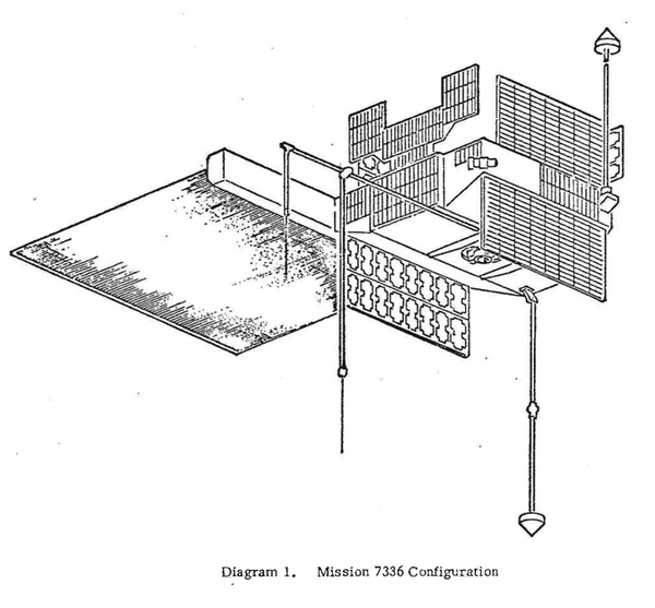
- Colonel Edwin F. Sweeney, Director, Memorandum for Chairman, SIGINT Overhead Reconnaissance Subcommittee, “Mission Description of SIGINT Mission 7336 (SAVANT II),” August 7, 1969.
- Memorandum for the Members of the SIGINT Overhead Reconnaissance Subcommittee, “Technical Mission Description of WESTON, SIGINT Mission 7313,” [Deleted name], Executive Secretary, SIGINT Overhead Reconnaissance Subcommittee, March 11, 1969. With attached: Memorandum for Chairman, SIGINT Overhead Reconnaissance Subcommittee, “Mission Description of SIGINT Mission 7313 (WESTON),” Col. Edwin F. Sweeney, USAF, Deputy Director for Satellite Operations, March 11, 1969.
- Ibid.
- “The SIGINT Satellite Story,” 1994, p. 4; p. 269.
- National Reconnaissance Office, “NSA in Space,” April 1975, pp. 30-32.
- Colonel Lew Allen, Jr., Memorandum for Mr. R.L. Hewitt, CIA/OSR, “Additive NRP Costs Associated with Monitoring SALT Option III, IV, or V,” October 30, 1969.
- Ivan Amato, Taking Technology Higher – The Naval Center for Space Technology and the Making of the Space Age, U.S. Naval Research Laboratory, 2022, pp. 247-249.
- The code-name FARRAH apparently first became public in Seymour Hersh’s account of the 1983 Soviet shootdown of the South Korean KAL007 airliner after the 747 strayed into Soviet airspace. Seymour Hersh, The Target Is Destroyed, Random House, 1986, p. 51.
- Telex, Harry Shlaudeman, American Embassy Buenos Aires, to Secretary of State, “Sinking of the Belgrano: Alleged U.S. Role,” May 4, 1982.
- In 1986, Aldridge became Secretary of the Air Force, but still retained the NRO directorship.
Note: we are using a new commenting system, which may require you to create a new account.